Published on : 06 Mar 2026
Breaking: Two weeks after the historic Blizzard of 2026 paralyzed the Northeast, the final toll reveals a catastrophic winter storm that shattered 48-year-old records and stands as one of the costliest natural disasters in US history. Here’s the complete damage assessment.
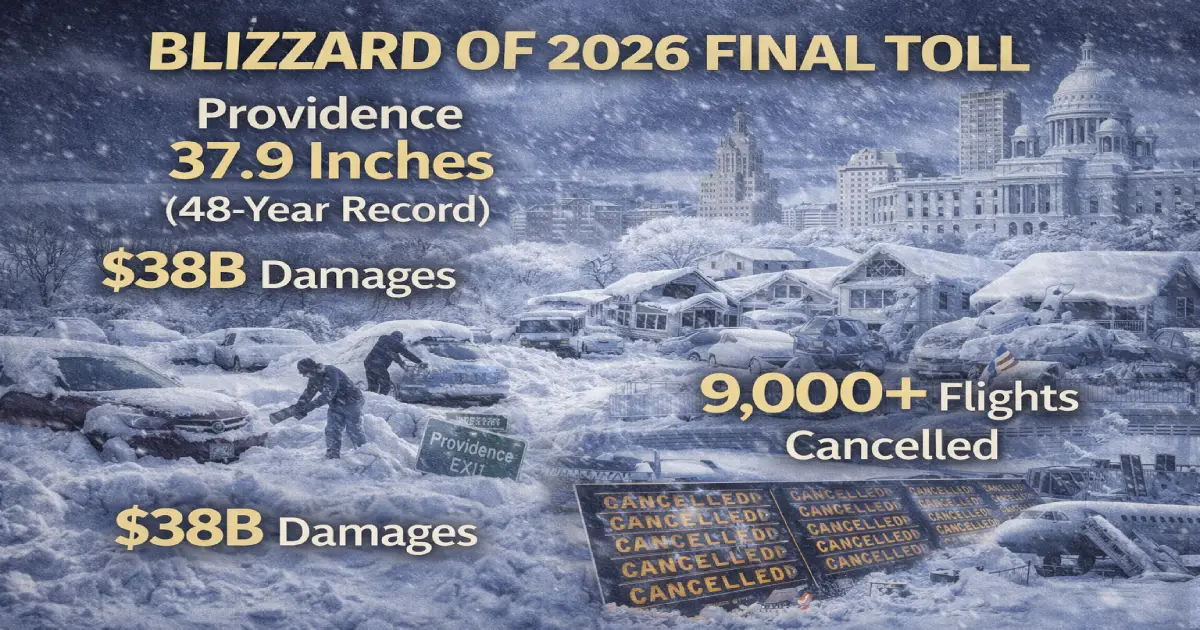
Published: March 6, 2026 Storm Dates: February 22-24, 2026 Peak Impact: Monday, February 23, 2026 Record Broken: Providence 37.9″ (beat 1978’s 28.6″ by 9.3 inches!) Total Economic Damage: $34-38 billion Deaths: 4 confirmed (Maryland: 2, Pennsylvania: 2)
The Blizzard of 2026 rewrote weather history across six states. Providence, Rhode Island’s 37.9 inches demolished a 48-year-old record set by the legendary Blizzard of ’78. The bomb cyclone’s $34-38 billion price tag ranks it among the costliest winter storms ever—approaching Hurricane Sandy’s economic impact.
Here’s what happened when 40 million Americans got buried under feet of snow in three days.
Record Snowfall:
✈️ Providence, RI: 37.9 inches (state record, beat 1978 by 9.3″) ✈️ Fall River, MA: 41 inches (Massachusetts leader!) ✈️ Newark, NJ: 27.1 inches (2nd-largest storm in city history) ✈️ New York City: 19.7 inches (snowiest winter since 2014-15) ✈️ Philadelphia: 14 inches (broke daily record from 1987)
The Devastation:
✈️ 9,000+ flights cancelled (Feb 22-24 peak) ✈️ 644,062 power outages at peak across Northeast ✈️ $34-38 billion damages (AccuWeather estimate) ✈️ 4 deaths (Maryland: 2, Pennsylvania: 2) ✈️ Hurricane-force winds: 83 mph at Nantucket, MA
At 7 p.m. Monday, February 23, 2026, Providence’s T.F. Green Airport recorded 37.9 inches—officially the worst snowstorm in Rhode Island’s recorded history.
Why This Is Incomprehensible:
The 37.9-inch total exceeds the past two winters combined (2023-24 + 2024-25). Providence got more snow in one storm than in 24 months of normal winter weather.
Monday Feb 23 Alone: 35.5 inches fell in a single day—nearly doubling the previous one-day record of 19 inches set in 1996.
The Blizzard of ’78 Comparison:
For 48 years, the Blizzard of 1978 (28.6 inches) was Rhode Island’s benchmark. Everyone measured storms against ’78. The 2026 storm beat it by 32%—not a close call, a demolition.
Other Rhode Island Totals:
What Made This Storm So Intense?
The nor’easter underwent bombogenesis—a rapid strengthening where central pressure drops 24+ millibars in 24 hours. This storm’s pressure fell 40 millibars over 24 hours, fueling:
Meteorologists call it a “once-in-50-years” event. Dr. Jung-Eun Lee (Brown University) attributed it to sudden stratospheric warming combined with a strong low-pressure system off Cape Cod—the perfect recipe for historic snowfall.
Top Totals:
The Jackpot Zone:
Southeastern Massachusetts—Plymouth and Bristol Counties—saw 30-41 inches while Boston proper got “only” 17 inches. A 30-mile difference created a 20+ inch snowfall gradient.
Power Outages:
Hurricane-Force Winds:
Government Response:
Legendary Moments:
Providence’s 37.9 inches officially dethroned the Blizzard of ’78 after 48 years.
What This Means:
The Blizzard of ’78 killed 100+ people and paralyzed New England for days. It was the storm everyone compared everything to—until now. The 2026 storm delivered objectively more snow, though better forecasting and preparation prevented mass casualties.
Government Response:
Power Restoration:
Multi-day effort, some areas waited 5-6 days for electricity. RIE serves 99% of state, making outages nearly universal in affected zones.
Snowfall:
Mayor Zohran Mamdani’s Response:
Broadway Dark:
All performances cancelled Sunday-Monday—first complete shutdown since COVID-19.
Transit Chaos:
State Response:
Top Totals:
Power Outages:
Blizzard Conditions:
Flight Disruptions:
Newark Liberty (EWR): 800+ cancellations Feb 23
Government Response:
Budget Strain:
Storm crews faced depleted budgets after multiple winter storms earlier in 2025-26 season—creating financial pressure on municipalities.
Hardest-Hit Towns:
Snowfall:
Philadelphia International Airport: 14 inches (broke daily record from 1987, making 2026 the 15th snowiest winter on record)
Casualties:
Lower Nazareth: 2 deaths in multi-vehicle crash (storm relation unconfirmed)
Power Outages:
A&N Electric Cooperative: 7,258 customers without power by morning Feb 23
Casualties:
2 fatalities when tree fell on car carrying 3 passengers
Crashes:
343 crashes reported by Maryland State Police on snow-covered roads
Power Outages:
Worcester County: 15,000+ outages
Damage:
Ocean City: Damaged trees leaning toward houses, blocked roads/sidewalks
AccuWeather estimates $34-38 billion total economic impact—making this one of the costliest winter storms in US history, rivaling:
What’s Included:
Lost Business Revenue ($12-15B):
Infrastructure Damage ($8-10B):
Emergency Response ($3-5B):
Airport/Transit Shutdowns ($5-7B):
Power Restoration ($2-3B):
Agriculture/Supply Chain ($3-5B):
Total Air Travel Impact (Feb 22-24):
Worst-Affected Airports:
LaGuardia (LGA): Nearly 100% cancellation rate Monday Feb 23—complete shutdown during blizzard peak
Newark Liberty (EWR): 800+ cancellations Feb 23 with 27.1″ snowfall at airport
Boston Logan (BOS): 2,200+ cancellations Tuesday Feb 24 (highest single-day disruption!)
Passenger Nightmare:
Airline Waivers:
Weather waivers issued for rebooking, but crews/aircraft repositioned from South/West took days to restore normal operations.
Peak Monday Feb 23, ~11:30 a.m.:
Why So Many Outages?
Heavy wet snow (lower snow-to-liquid ratio = heavier) + hurricane-force winds (60-83 mph) + prolonged event (20+ hours) = perfect storm for grid damage.
Trees/branches broke under weight, falling onto lines. Wind gusts snapped poles. Tangles required careful repairs.
Restoration Timeline:
Challenges:
What Is Bombogenesis?
Official definition: Central air pressure drops at least 24 millibars in 24 hours. This storm dropped 40 millibars—a dramatic intensification rare even for hurricanes.
What Fueled It:
Result: 4-5 inch per hour snowfall rates instead of typical 1-2 inches.
Blizzard Conditions at 15+ Airports:
True blizzard criteria (35+ mph winds, <0.25 mile visibility, 3+ hours duration) met simultaneously at:
With 35+ inches of snow melting as temperatures surge 10-20°F above normal this week, the National Weather Service has issued:
What to Watch:
AccuWeather forecasts temps challenging daily records this week—the rapid warm-up creates new hazards even as the blizzard fades into memory.
Blizzard of 1978 vs Blizzard of 2026:
| Metric | 1978 | 2026 | Winner |
|---|---|---|---|
| Providence Snowfall | 28.6″ | 37.9″ | 2026 (+9.3″) |
| Deaths | 100+ | 4 | 1978 (worse) |
| Power Outages | Widespread | 644,062 peak | 1978 (longer duration) |
| Economic Impact | ~$2.5B (adjusted) | $34-38B | 2026 (15x worse!) |
| Warning Technology | Minimal | Advanced | 2026 (better prepared) |
The Verdict:
The Blizzard of 1978 was deadlier and felt more catastrophic due to limited warning and multi-day paralysis. But the Blizzard of 2026 delivered objectively more snow and caused vastly more economic damage due to modern infrastructure affected.
Technology and preparation saved lives in 2026, even if the snow totals were worse.
If you’re planning Northeast travel in coming weeks:
Check for Delayed Flights:
Airlines are still repositioning crews/aircraft from disruptions. Monitor FlightAware real-time tracking.
Watch for Flood Warnings:
Spring melt creates ice jam flooding risks. Check local alerts before traveling to Pennsylvania, New York, Massachusetts.
Budget Extra Time:
Some secondary roads still have snow piles, narrowing lanes. Add 15-30 min for local driving.
Airport Delays Possible:
Residual crew scheduling issues may cause occasional delays through mid-March.
The Blizzard of 2026 rewrote Northeast weather history. Providence’s 37.9 inches demolished a 48-year-old record. The $34-38 billion price tag ranks it among the costliest winter storms ever. Four people lost their lives, 644,062 sat without power for days, and over 9,000 flights were cancelled.
Two weeks later, as 35+ inches of snow melts under above-normal temperatures, the Northeast faces a new threat: ice jam flooding. The storm’s legacy continues.
For those who lived through it—shoveling 3 feet of snow, enduring multi-day power outages, or sleeping on airport floors—the Blizzard of 2026 will forever be the benchmark. It has officially dethroned the legendary Blizzard of ’78.
The Blizzard of 2026 is over. The recovery continues. Spring flooding is the new concern as historic snow melts under rapid warm-up.
For More Resources:
Related Articles:
Posted By : Vinay
Lastest News
2nd Floor, 39, Above Kirti Club, DLF Industrial Area, Kirti Nagar, New Delhi, Delhi 110015
Travel Tourister is a leading Travel portal where we introduce travellers to trusted travel agents to make their journey hasselfree, memorable And happy. Travel Tourister is a platform where travellers get Tour packages ,Hotel packages deals through trusted travel companies And hoteliers who are working with us across the world. We always try to find new and more travel agents and hoteliers from every nook and corners across the world so that you could compare the deals with different travel agents and hoteliers and book your tour or hotel with the one you have chosen according to your taste and budget.
Copyright © Travel Tourister, India. All Rights Reserved
 Call
Call Enquiry