Published on : 16 Feb 2026
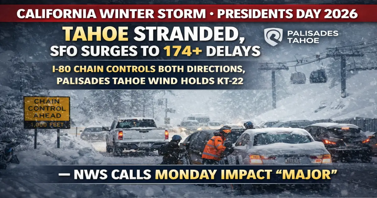
Breaking: A powerful multi-day winter storm system is tearing through Northern California and the Sierra Nevada on Presidents Day February 16, 2026, delivering the most significant Sierra snowfall event of the season — with up to four feet of snow forecast at Donner Summit elevations above 7,000 feet, 60-plus inches projected at Palisades Tahoe and Sugar Bowl, I-80 running under mandatory chain controls in both directions from the Nevada state line, the National Weather Service’s Reno office formally classifying today’s Monday travel impact as “Major,” the California state Sacramento–South Lake Tahoe and Truckee–Reno bus services cancelled entirely through February 17, San Francisco International Airport recording 174-plus flight delays under an active FAA Ground Delay Program with average waits of 55 minutes already extending toward two-hour warnings, Oakland recording 11 delays, San Jose 19 delays, Palisades Tahoe implementing wind holds on KT-22 and the Upper Mountain with avalanche mitigation work blocking primary access routes, and an estimated 20,000-plus Lake Tahoe Presidents Day weekend visitors now facing the “Great Monday Exodus” — the return home — into the worst travel conditions of the entire holiday weekend. Here is everything stranded Tahoe visitors, SFO-bound passengers, and I-80 drivers need to know right now.
Published: February 16, 2026 (Presidents Day) Storm Duration: Sunday Feb 15 through Wednesday Feb 18 (ongoing) NWS Monday Travel Impact Classification: MAJOR Donner Summit Snow Forecast: 4 feet (elevation 7,000+ feet) Palisades Tahoe + Sugar Bowl Forecast: 60+ inches total storm accumulation I-80 Status: Chain controls both directions — Nevada state line to Drum Forebay Sacramento→Tahoe Buses: CANCELLED February 16–17 (California state transit) Truckee→Reno Buses: CANCELLED February 16–17 SFO Delays: 174+ flights delayed, FAA Ground Delay Program active, 55-min average extending to 2+ hours OAK Delays: 11 delays SJC Delays: 19 delays Bay Area Flights Impacted: 15%+ of all scheduled weekend flights Palisades Tahoe: Wind holds on KT-22, Headwall, Upper Mountain — avalanche mitigation ongoing Stranded Tahoe Visitors: 20,000+ attempting Presidents Day return Snow Level Drop: Potentially to 4,000 feet — affecting roadways in Tahoe basin itself California Reservoir Context: Oroville, Folsom, Shasta benefiting — critical snowpack building
A powerful winter storm system is currently tearing through Northern California and the Sierra Nevada, turning a weekend of leisure into a logistical challenge. The National Weather Service in Sacramento has issued a series of urgent Winter Storm Warnings that remain in effect through the holiday weekend.
In a travel forecast targeting the Sierra Nevada, the National Weather Service’s Reno office warned that by Monday, weather conditions will degrade — with the snow level possibly plunging below 5,000 feet. The agency categorized the Monday evening travel impacts as “Major,” a sign that the ski commute between Lake Tahoe and the Bay Area could get messy as the long Presidents Day Weekend wraps up.
Today is that Monday. The NWS warning is in effect right now. And the passengers, skiers, and drivers it warned about are attempting to navigate the worst travel conditions of the holiday weekend simultaneously — on the single busiest return-travel day of the entire Q1 2026 calendar.
The storm’s reach has brought heavy rain and gusty winds to the coastal regions and the Central Valley, creating a ripple effect at major airports. San Francisco International, Oakland, and San Jose have reported significant delays. According to flight-tracking data, over 15% of scheduled flights for the holiday weekend have been impacted by either delays or outright cancellations.
The compound effect — airport chaos in the Bay Area, road chaos in the Sierra, lift closures at the resorts — means there is no easy escape route for the 20,000-plus Presidents Day weekend visitors currently in the Tahoe basin attempting to return home today.
Over 174 flights have been delayed at SFO, with delays currently averaging 55 minutes, but the FAA advisory warns it may extend beyond two hours.
The Federal Aviation Administration announced a ground delay program at San Francisco International Airport as gusty winds, rain, and low clouds slowed operations.
The issue is two-fold: low visibility for incoming flights and high-altitude turbulence that has forced carriers to reroute or ground aircraft. Travelers are being urged to check their flight status before even leaving for the airport, as many “gate delays” are turning into multi-hour waits.
Why SFO is uniquely vulnerable to this storm:
SFO’s geography is the primary problem. Built on a peninsula in San Francisco Bay, the airport operates two parallel runway pairs that are both exposed to Bay wind conditions. When the storm tracks south winds across the Bay — as it is today — SFO’s normal runway configuration becomes impossible and the airport must reverse operations. Airport Duty Manager Crystal David explained: “So you always want to take off into the direction of the wind, and normally that’s west-northwest. But today, these winds are coming out of the south. So essentially, what we’ve had to do is a 180 on how we’re taking off and landing.”
A 180-degree runway reversal at SFO does not just create inconvenience — it fundamentally changes the approach and departure procedures for every aircraft, forcing pilots onto less familiar routing profiles and reducing the number of simultaneous operations the airport can safely handle. The result: fewer aircraft movements per hour, every aircraft in the queue waiting longer, and every arriving flight’s delay cascading into the departing aircraft that needs it.
SFO airlines most affected today:
DOT Passenger Rights reminder at SFO today:
Fellow Bay Area airports are experiencing relatively fewer delays. Oakland San Francisco Bay Airport had 11 delays.
Oakland’s dramatically lower delay count today — 11 versus SFO’s 174 — reflects its different runway orientation and exposure profile. Oakland sits on the east side of the Bay, partly sheltered from the dominant south wind pattern hitting SFO. On days when SFO is experiencing runway configuration reversals, Oakland frequently operates with minimal disruption.
Oakland as a SFO alternative today:
San Jose Mineta International Airport had 19 delays.
San Jose’s 19 delays reflect moderate storm impact — more than Oakland, less than SFO. SJC serves Silicon Valley’s tech workforce with strong Alaska, Southwest, and United presences. For South Bay passengers, SJC remains operationally superior to SFO today. Caltrain connects San Jose to SFO in 60–75 minutes for passengers who need SFO access despite SJC being their local airport.
With significant snowfall expected Monday through Wednesday, guests should anticipate changing conditions, including wind holds, delayed lift openings, and staggered terrain access as mountain operations teams conduct avalanche mitigation. KT-22, Headwall, and the Upper Mountain at Palisades are expected to experience potentially significant delays in opening during the storm, especially on Monday and Tuesday, even into Wednesday. Mountain operations teams are likely to lose access to primary routes up East Face Road and Saddle Road with all of the snow.
KT-22 is Palisades Tahoe’s crown jewel — the expert lift that gives access to the resort’s most famous steep terrain and draws advanced skiers from across California and beyond. Its closure today on Presidents Day — the most visited day of the season — means thousands of skiers who paid $109–$200 for lift tickets are skiing a fraction of their expected terrain.
Palisades Tahoe spokesman Patrick Lacey said on these “big powder days” visitors should expect delays on the mountain. “We want to make sure our guests are safe, and our team is working at the speed of safety.” He said. “This big storm is coming in and we’re going to get buried. It’s going to be a significant amount of snow coming down.”
Snow accumulation at Palisades Tahoe: At spots like Palisades Tahoe and Sugar Bowl, 60-plus inches of snow are expected as the storm cycle uncorks further early next week, according to OpenSnow, a forecasting service favoured by skiers.
Sixty inches of new snow — five feet — is simultaneously the best news and worst news possible for Presidents Day weekend visitors. The snowpack California desperately needs is arriving. The ability to ski it safely, drive home from it, or fly away from it is severely compromised.
Ikon Pass refund policy during wind holds: Ikon Pass holders whose day is significantly impacted by mountain closures can request a credit through the Ikon Pass app. A “significant” disruption is generally defined as less than 50% of terrain operating for more than 50% of operational hours. Today’s wind holds on KT-22 and Upper Mountain at Palisades likely qualify. File your credit request at ikonpass.com before end of day.
Heavenly, Vail Resorts’ flagship Lake Tahoe property straddling the California–Nevada border above South Lake Tahoe, is experiencing similar storm conditions to Palisades. While the fresh snow is a boon for ski resorts like Palisades Tahoe and Heavenly, the high winds have forced the closure of many lifts at these resorts.
Heavenly’s gondola — the resort’s primary access point from the South Lake Tahoe base — is particularly wind-sensitive. When sustained winds exceed 35–40 mph at summit elevations, the gondola automatically halts for safety. Summit elevations at Heavenly are recording those and higher wind speeds today.
Epic Pass holders at Heavenly: Vail Resorts’ Epic Pass credit policy mirrors Ikon’s — significant lift closures qualify for day credits. Submit through the Epic Pass app or at the resort guest services desk before leaving the mountain.
The storm comes amid a largely dry season with few powder days, which has seen the snowpack across the Sierra Nevada plunge below normal. Thinner snow cover in the mountains can cause concerns about future wildfires and lessened water resources.
Meteorologist Mark Finan, who has been forecasting weather in the region for 35 years, said: “It will help. It may not get us back to average, because we’ve gone so long without much rain and snow. But every little bit helps.” He added: “This is about building that snowpack. That’s what carries us through the dry months.”
The storm that is stranding skiers and closing lifts today is simultaneously replenishing the water supply that 40 million Californians depend on. Oroville, Folsom, and Shasta reservoirs are stable — but what California truly needs is sustained snowpack that melts gradually through spring and summer. Every inch falling on Donner Summit today is water that California will drink in June.
I-80 is under chain controls in both directions from the Nevada State line to Drum Forebay. SR-89 is under chain controls from Truckee to Tahoe City. SR-28 is under chain controls from Tahoe City to Kings Beach. SR-267 is under chain controls from Northstar to Kings Beach.
Chain controls on I-80 mean every vehicle without All-Wheel Drive or 4-Wheel Drive must carry and install approved tire chains before proceeding through the Sierra. About 30,000 vehicles cross Donner Summit per day. About 6,000 of those vehicles are semi-truck trailer rigs. Those trucks carry something between $4 to $8 million in cargo over the Sierra each hour.
The chain control requirement levels in force today:
Snow level dropping to 4,000 feet is the critical number today. Meteorologist Mark Finan warned: “This is the kind of storm where you might get six to eight inches in a day, then maybe a foot and a half on Monday. It will vary from time to time, but over several days it adds up.” When snow falls to 4,000 feet — below the 4,748-foot elevation of Truckee — the Tahoe basin itself is snowing. Roads within South Lake Tahoe, Stateline, and Truckee become snow-covered, not just mountain passes.
Caltrans QuickMap real-time I-80 conditions: quickmap.dot.ca.gov — check this before ANY attempt to drive I-80 today.
Bus operations are CANCELLED between Sacramento and South Lake Tahoe (Highway 50). Bus operations are CANCELLED between Truckee and Reno/Sparks (Highway 80). Connecting bus service between Sacramento and Auburn on Highway 80 will continue to operate.
This is the cancellation that most Tahoe visitors don’t know about yet. California state transit services — the primary non-driving alternative for visitors who travelled to Tahoe without a car — are completely suspended today and tomorrow. If you arrived by bus from Sacramento and planned to leave by bus today, your service does not exist. Your alternatives:
For South Lake Tahoe visitors attempting to reach Reno or cross to Nevada, if you need to get to or from Lake Tahoe and Mt. Rose Highway is closed, you should use US-50 through Carson City.
US-50 (Echo Summit route) offers a lower-elevation alternative to I-80’s Donner Pass crossing — but it is longer (adds 45 minutes to Reno) and is itself subject to chain controls and weather closures during severe storms. Check US-50 status at quickmap.dot.ca.gov before committing to the route.
Meteorologists predict that the heaviest bands of the storm will begin to taper off late Monday evening, just as the holiday weekend concludes. However, this creates a new set of problems: The “Great Monday Exodus.”
Every visitor who extended their Tahoe stay through Presidents Day Monday — tens of thousands of people — is now attempting to leave simultaneously in the worst driving and flying conditions of the weekend.
Behind the weather maps and the traffic alerts are real people whose holiday plans have been upended. There’s the family from San Jose whose “quick trip” to Truckee turned into an eight-hour ordeal on I-80. There are the stranded passengers at SFO, curled up with blankets near charging stations, waiting for a break in the clouds.
The timing strategy for I-80 today:
| Time Window | I-80 Conditions | Recommendation |
|---|---|---|
| 6:00–8:00 AM | Chains required, moderate traffic | Best window — leave NOW if you haven’t |
| 8:00 AM–12:00 PM | Heaviest snow, chain controls, high traffic | AVOID — worst conditions + peak exodus traffic |
| 12:00–3:00 PM | Moderate snow, high traffic | Risky — chains essential, budget 5–7 hours to Bay Area |
| 3:00–6:00 PM | Storm potentially tapering | Possible window — check Caltrans QuickMap before departing |
| 6:00 PM onwards | Storm tapering but dark + wet | Evening drive viable if storm clears as forecast |
| Tuesday AM | Post-storm clearing | Safest option — wait one day if possible |
There are the stranded passengers at SFO, curled up with blankets near charging stations, waiting for a break in the clouds.
United passenger flying SFO→Chicago O’Hare, originally departing 11:30 AM. FAA Ground Delay Program pushed departure to 1:45 PM, then 3:20 PM. Arrived ORD at 9:47 PM — missed connecting flight to Cincinnati. United rebooked onto 7:00 AM Tuesday morning. One unplanned night in Chicago.
United’s weather waiver for today’s SFO storm is published at united.com/waivers — eligible passengers can rebook for free through February 18 with no change fee and no fare difference on economy tickets.
San Jose family of four — drove up Friday February 13, booked South Lake Tahoe condo through Presidents Day. Planned departure: Monday 10 AM via I-80. Sunday evening: NWS “Major Impact” warning published. They debated leaving Sunday night vs waiting.
They waited. Monday 10 AM departure: I-80 chain controls in effect, 45 minutes to install chains they hadn’t used in two years, then a 7.5-hour crawl from Truckee to San Jose due to multiple spinouts blocking the roadway.
What they should have done: Left Saturday evening between storms, or waited until Tuesday morning when the storm tapering creates genuinely improved conditions.
Expert skier, drove from Sacramento to Palisades Tahoe Saturday for the powder. Planned to ski Sunday and Monday, drive home Monday evening. Sunday: incredible powder day, 18 inches overnight. Monday: KT-22 closed, Upper Mountain wind holds. Skied lower mountain in whiteout conditions — suboptimal.
Monday 3 PM: attempted I-80 departure. Road clear to Truckee, then full closure at Donner Lake interchange due to multiple semi-truck spinouts. Two-hour wait for Caltrans clearance. Arrived Sacramento at 9:30 PM, 6.5 hours for a 100-mile drive.
His verdict: “Next time I’m leaving Sunday afternoon when the powder is still incredible and the road is still open.”
✅ Check FlightAware NOW before leaving for the airport — average delay is 55 minutes but extending rapidly. If your flight shows 90+ minute delay, you have a window to get food, rest, and arrive at the airport calmly
✅ Check your airline’s weather waiver — United, Alaska, American, Delta, Southwest, and JetBlue have all published SFO weather waivers for today. Visit your airline’s website → “Travel Alerts” or “Manage Booking” to rebook for free
✅ Consider Oakland — if your SFO flight is cancelled and you have flexibility, check OAK alternatives. BART from Powell St/Civic Center to Coliseum: 25 minutes, $4.85. Then AirBART shuttle or OAK-specific BART station
✅ DOT rights if cancelled: Full cash refund to original payment method — not travel credit. Request explicitly at the service desk
✅ Meal vouchers: For delays caused by weather (ground program), airlines are NOT required to provide meal vouchers under DOT rules. However United and Alaska frequently offer goodwill vouchers — ask politely at the gate
✅ Check Caltrans QuickMap at quickmap.dot.ca.gov — live camera feeds, chain control locations, closure alerts
✅ Chains: If you do not have chains or AWD/4WD with snow tires, do NOT attempt I-80 today. CHP will turn you around at the control point and fine you for attempting to proceed without required equipment
✅ Best departure window: Early morning (before 8 AM) or evening (after 6 PM if storm tapers as forecast). Midday is the worst combination of heavy snow + maximum traffic
✅ Alternative route: US-50 through South Lake Tahoe → Carson City → US-50 back into California (Placerville). Longer, but may have shorter chain control sections
✅ Emergency kit: Blanket, water, snacks, portable charger, physical map — if you get stuck in a multi-hour I-80 closure, these are not optional
✅ Bus service is CANCELLED — Sacramento and Reno buses suspended February 16–17. Do not go to the bus stop
✅ Amtrak Zephyr — Truckee station, check amtrak.com for today’s timing. May run late due to snow on tracks but has more weather tolerance than buses
✅ Rideshare surge: Uber and Lyft operating, but expect $180–$280 from Truckee to Sacramento today. Worth it vs a two-day wait if you must return
✅ Wait until Tuesday: Bus service resumes February 17. The storm’s heaviest bands taper Monday evening. Tuesday is dramatically better than Monday for all transport modes
✅ Wind hold compensation: File for an Ikon Pass or Epic Pass credit if less than 50% of terrain opened for more than 50% of operational hours — check ikonpass.com and epicpass.com
✅ Lift ticket refunds: Individual day lift tickets (not pass days) at Palisades Tahoe can be exchanged for future-date credits if significant closures occurred — guest services desk or palisadestahoe.com
✅ Safety on open terrain: With avalanche mitigation ongoing on the upper mountain, stay on designated open runs only — out-of-bounds avalanche risk is extremely high during active storm loading
For skiers and snowboarders, the storm is welcome news. “It’s a gift for skiers,” meteorologist Mark Finan said. “We really need snow. This is the kind of snow the Sierra needs to last through the rest of the season.” After the storms pass through, the mountain will have a ‘nice refresh’ of snow that will have the resort ‘sitting pretty nicely’ through the season.
Beyond California, Utah and Colorado — two states that share the need for snow — are included in the storm track.
The silver lining for February–April skiing: Every inch of snow falling today on Palisades Tahoe, Heavenly, Northstar, Sugar Bowl, and Mammoth Mountain is extending the ski season. A resort with 60+ inches of new base snow in mid-February can realistically ski into May. The Presidents Day storm that is causing chaos today is the reason April and May Tahoe skiing will be exceptional.
Mammoth Mountain: California’s highest ski resort (11,053-foot summit) is also receiving significant snow accumulation from this storm system. Mammoth’s extended elevation means it can ski well into June following a storm of this magnitude. Spring skiing at Mammoth in t-shirts on excellent snow cover is one of the best experiences in US skiing — and this storm is building that base.
California’s Presidents Day 2026 winter storm has delivered exactly what it promised: a “Major” travel impact Monday February 16 combining 174-plus SFO flight delays under an active FAA Ground Delay Program, chain controls on I-80 in both directions from the Nevada state line, complete cancellation of Sacramento–Tahoe and Truckee–Reno bus services, wind holds on KT-22 and the Upper Mountain at Palisades Tahoe during avalanche mitigation, 60-plus inches of total accumulation at summit elevations — and 20,000-plus Tahoe visitors attempting the Great Monday Exodus into all of it simultaneously. The good news is that the storm is forecast to taper tonight, making Tuesday morning the genuinely best departure window for everyone currently in the Tahoe basin. If you can wait, wait. If you cannot, leave before 8 AM with chains, food, water, and a full tank — and check Caltrans QuickMap before every attempt at I-80.
Your Presidents Day Storm Action Checklist:
✅ Flying SFO today? Check airline weather waiver first — free rebooking through Feb 18 on most carriers ✅ SFO cancelled? Check OAK alternatives — 11 delays vs SFO’s 174. BART to OAK Coliseum: 25 min ✅ Driving I-80? Check quickmap.dot.ca.gov — chains required, 5–7 hours Bay Area drive time ✅ No chains or AWD? Do NOT attempt I-80 — CHP turning vehicles around at control points ✅ Best driving window? Before 8 AM or after 6 PM if storm tapers — avoid 8 AM–3 PM ✅ Stranded without car? Buses CANCELLED — try Amtrak Zephyr at Truckee or rideshare ($180–$280) ✅ Ski lifts closed? File Ikon/Epic Pass credit at ikonpass.com / epicpass.com ✅ Can you wait? Tuesday morning is dramatically better — storm tapers overnight
Track California storm conditions live:
For More Resources:
Related Articles:
Posted By : Vinay
Lastest News
2nd Floor, 39, Above Kirti Club, DLF Industrial Area, Kirti Nagar, New Delhi, Delhi 110015
Travel Tourister is a leading Travel portal where we introduce travellers to trusted travel agents to make their journey hasselfree, memorable And happy. Travel Tourister is a platform where travellers get Tour packages ,Hotel packages deals through trusted travel companies And hoteliers who are working with us across the world. We always try to find new and more travel agents and hoteliers from every nook and corners across the world so that you could compare the deals with different travel agents and hoteliers and book your tour or hotel with the one you have chosen according to your taste and budget.
Copyright © Travel Tourister, India. All Rights Reserved
 Call
Call Enquiry