Published on : 19 Jan 2026
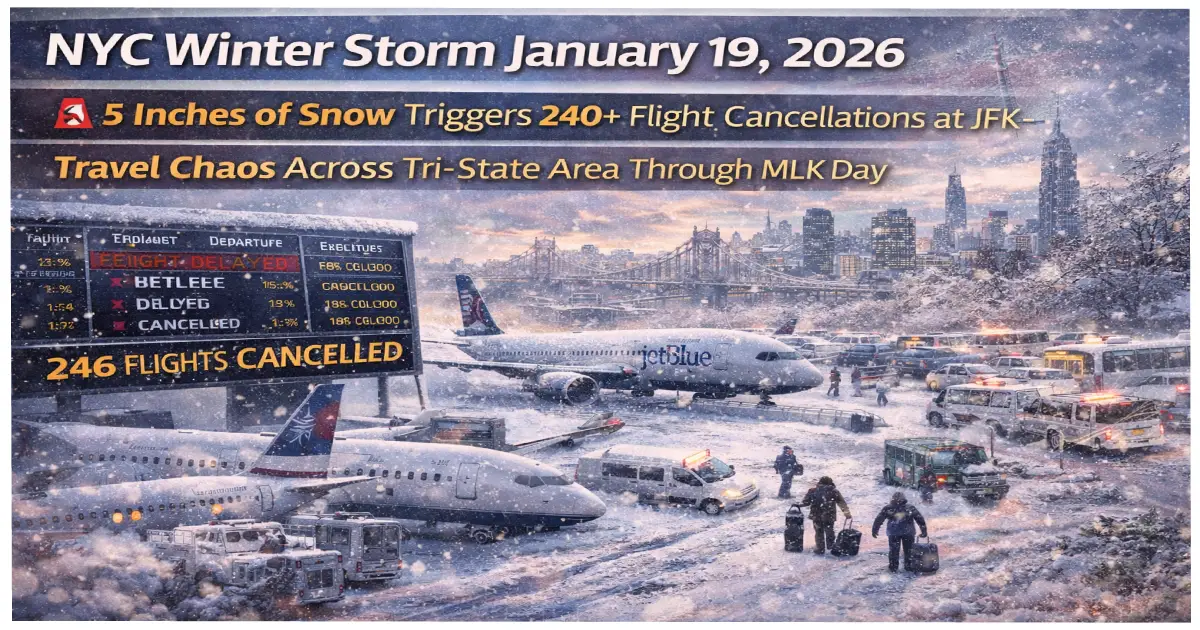
Breaking: NYC just got slammed with up to 5 inches of snow on January 19, 2026—triggering Martin Luther King Jr. Day travel chaos. JFK leads the nation with 240+ cancellations, LaGuardia grinds to a halt with ground stops, and 2,700+ flights nationwide face delays. Here’s everything you need to know if you’re trying to fly today or tomorrow.
Published: January 19, 2026 Storm Duration: Sunday January 18 – Tuesday January 21, 2026 NYC Accumulation: 3-5 inches (more coming tonight) Upstate NY: 10-20 inches through Wednesday Flights Cancelled: 240+ at JFK, 200+ at LaGuardia, 150+ at Newark Nationwide Delays: 2,700+ flights (and counting) Wind Chill Monday Night: -20°F upstate, teens in NYC
The winter storm hit NYC in TWO waves—just like forecasters warned:
Wave 1 (Sunday Morning): 1-2 inches fell but melted quickly Wave 2 (Sunday Afternoon/Evening): 2-4 MORE inches sticking around
The National Weather Service extended the Winter Weather Advisory through midnight tonight for NYC, New Jersey, and Connecticut. Temperatures are dropping FAST—high of 35°F today, plunging to 23°F overnight—meaning everything freezes solid.
Current Nightmare Airports:
✈️ JFK: 60 arrivals + 61 departures cancelled before noon (121 total!) ✈️ LaGuardia: 49 flights cancelled EACH direction (98 total!), ground stops extended to 9:30 PM ✈️ Newark: 50-minute average delays, low cloud coverage killing visibility ✈️ Total Delays Nationwide: Over 2,700 flights (NYC accounts for majority)
FlightAware data shows JFK leading the ENTIRE NATION in cancellations. Again. Because of course it does.
The Department of Sanitation activated its Snow Alert Sunday at 4:00 AM—deploying:
But here’s the problem: temperatures Saturday night dropped BELOW freezing, meaning snow that fell Sunday afternoon isn’t melting. It’s sticking. And tonight’s low of 18°F means everything turns into an ice rink.
Hazards RIGHT NOW:
❄️ Flash freezing on roads, bridges, sidewalks ❄️ Reduced visibility during peak afternoon snowfall ❄️ Slip-and-fall danger (MTA warns of “peak hazards”) ❄️ Property owners: Clear sidewalks within 12 hours (minimum 4-foot path or face fines)
Important MLK Day Changes:
Mayor Eric Adams warned: “Don’t drive unless absolutely necessary.”
While NYC deals with 5 inches, upstate faces a MONSTER storm through Wednesday:
Northern Herkimer County:
Central NY Cities:
Governor Kathy Hochul declared a State of Emergency, activating:
Wind Is the REAL Problem:
After the snow comes the Arctic blast. And it’s BRUTAL.
Wind Chill Forecast:
🥶 Adirondacks/North Country: -20°F to -25°F Monday night 🥶 Upstate NY: Single digits to below zero 🥶 NYC Metro: Wind chills in the teens 🥶 Tuesday Morning: Widespread sub-zero wind chills across region
The National Weather Service warns: Frostbite possible in 30 minutes on exposed skin.
Safety Guidelines:
If you were hoping to fly out of NYC on MLK Day weekend, you picked the WORST possible time.
By Noon Sunday:
Airlines affected most: United, JetBlue, American, Delta
Current Status:
Sunday Operations:
United and JetBlue waived change fees—smart travelers are rebooking NOW before flights fill up.
NYC airports don’t operate in a vacuum. When they go down, the ENTIRE national network suffers:
This is EXACTLY what happened January 5, 2026 when a similar storm caused 180 cancellations + 3,000 delays.
The storm extends WAY beyond NYC:
South Dakota, Nebraska, Kansas:
Northern & Eastern Georgia:
If Your Flight Is Today/Tomorrow:
If Driving:
🚗 Avoid unnecessary travel (seriously, just don’t) 🚗 Bridges freeze first (reduce speed significantly) 🚗 Emergency kit required: Blankets, water, flashlight, phone charger 🚗 Clear exhaust vents before starting car (carbon monoxide danger!) 🚗 DON’T push snow into streets (illegal + impedes plows)
Mass Transit Users:
🚇 Allow 30-45 extra minutes for delays 🚇 Use handrails at stations (slip-and-fall peak) 🚇 Check MTA alerts before leaving 🚇 Consider working from home Monday if possible
A Travel Advisory is in effect for ALL of Erie County starting 10 PM Sunday.
What That Means:
Buffalo residents: Stock up NOW. This is multi-day event.
Monday, January 20 (MLK Day):
Tuesday, January 21:
Wednesday, January 22:
Bottom Line: If you can delay travel until Thursday, DO IT.
Short Answer: Not record-breaking, but significant.
Context:
This January 2026 storm is tracking COLDER than recent years—ending the near-record warmth trend since 2020.
So while not historic, it’s definitely above average for modern NYC winters.
Track Snow Removal:
Check Flight Status:
Road Conditions:
Emergency Services:
Government Updates:
The January 19, 2026 winter storm represents major disruption across NYC and the Northeast during one of the busiest travel weekends of winter.
The Numbers:
What You Need to Know:
✅ Check flight status obsessively (things change minute-by-minute) ✅ Avoid unnecessary travel through Tuesday ✅ Expect airport chaos at least 48 more hours ✅ Dangerous cold Monday/Tuesday nights ✅ Conditions improve Wednesday onward
The combination of heavy snow + dangerous wind chills + MLK Day holiday demand = perfect storm for transportation chaos.
Authorities emphasize: This WILL get better by mid-week. But you need to prepare for at least 48 MORE hours of winter weather impacts.
Stay safe. Check on neighbors. And seriously—skip that Monday flight if you can.
For Real-Time Updates:
Bookmark this page and follow official weather/airport advisories. Conditions are evolving rapidly—what’s true at noon may be different by 3 PM.
Southwest’s January 27 change is irrelevant right now—you need to survive THIS storm first.
For More Resources:
Related Articles:
Posted By : Vinay
Lastest News
2nd Floor, 39, Above Kirti Club, DLF Industrial Area, Kirti Nagar, New Delhi, Delhi 110015
Travel Tourister is a leading Travel portal where we introduce travellers to trusted travel agents to make their journey hasselfree, memorable And happy. Travel Tourister is a platform where travellers get Tour packages ,Hotel packages deals through trusted travel companies And hoteliers who are working with us across the world. We always try to find new and more travel agents and hoteliers from every nook and corners across the world so that you could compare the deals with different travel agents and hoteliers and book your tour or hotel with the one you have chosen according to your taste and budget.
Copyright © Travel Tourister, India. All Rights Reserved
 Call
Call Enquiry