Published on : 29 Jan 2026
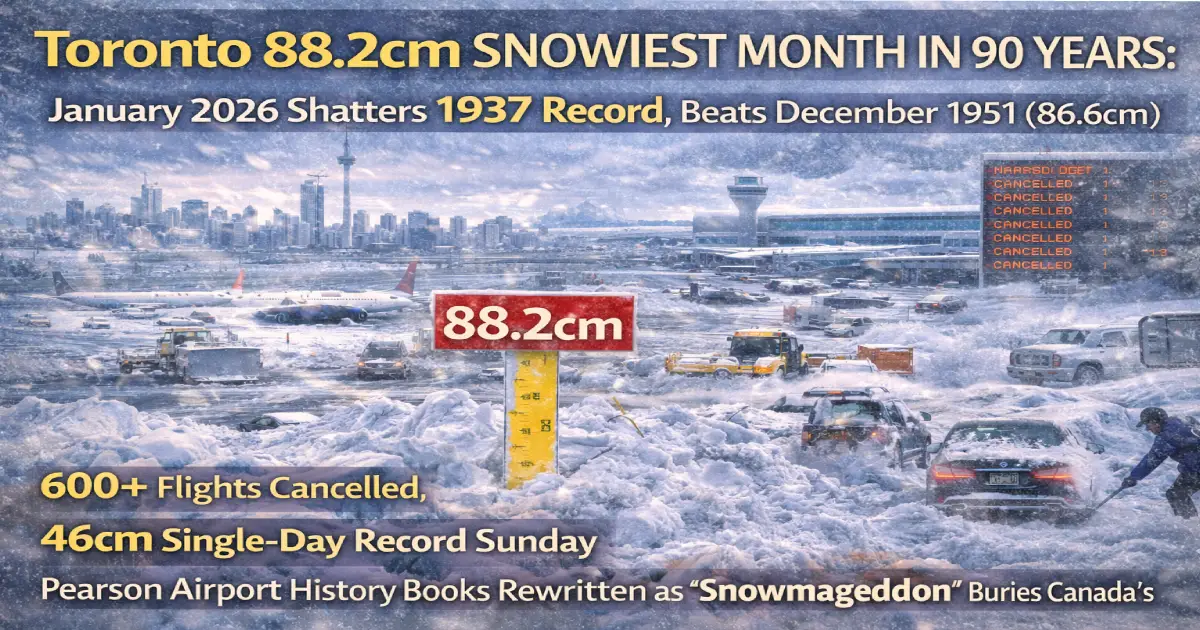
HISTORIC MILESTONE: Toronto Pearson International Airport recorded 88.2 centimetres (34.7 inches) of snowfall in January 2026—officially the SNOWIEST MONTH since records began in 1937 (90 years ago!) and surpassing the previous all-time record of 86.6cm set in December 1951. Sunday January 25’s single storm dumped 46cm (18 inches) at Pearson—the highest daily snowfall on record—while downtown Toronto saw 56cm. Here’s how “Snowmageddon” rewrote Toronto weather history, paralyzed Canada’s busiest airport with 600+ flight cancellations, and why Environment Canada says “we’re not done yet” with more flurries forecast through Friday.
Published: January 29, 2026 Record Broken: January 2026 = 88.2cm (SNOWIEST MONTH EVER) Previous Record: December 1951 = 86.6cm (held for 75 years!) Records Begin: 1937 (90 years of data) Single-Day Record: 46cm at Pearson Sunday January 25 (previous: 13.8cm in 2023) Downtown Total Sunday: 56cm (lake-effect enhancement) Flights Cancelled: 600+ at Pearson in 24 hours (560 Sunday alone) Schools Closed: Monday January 26 (TDSB, TCDSB, universities) City Response: 600 plows, 1,300 staff mobilized, “days” to clear Transit Chaos: TTC Line 1 partial shutdown, Line 6 Finch down (again!) Comparison to 1999: Still LESS than January 1999’s 145cm (army called in)
Environment Canada confirmed Monday January 27, 2026 that Toronto Pearson International Airport’s 88.2 centimetres of January 2026 snowfall represents:
✅ SNOWIEST JANUARY in 90 years of records (since 1937) ✅ SNOWIEST MONTH OF ANY MONTH in 90 years (beats December 1951’s 86.6cm) ✅ 46cm single-day record Sunday January 25 (previous January record: 13.8cm in 2023) ✅ Downtown Toronto 56cm same day (lake-effect enhancement made it even worse)
What This Means:
In 90 years of weather records at Toronto Pearson (and its predecessor weather stations), January 2026 is the SNOWIEST SINGLE MONTH EVER RECORDED—not just snowiest January, but snowiest month period.
Previous Record Holder:
December 1951: 86.6cm Held Record: 75 years (1951-2026) Broken By: 1.6cm margin (88.2cm – 86.6cm)
Third Place:
January 1999: ~65-70cm (estimated, incomplete data) BUT: January 1999 had multiple storms totaling 145cm+ when combined, making it snowier OVERALL but not as a single calendar month’s accumulation at one location.
Sunday January 25, 2026 alone rewrote Toronto’s single-day snowfall record books:
At Toronto Pearson Airport:
✈️ 46 centimetres (18 inches) in 24 hours ✈️ Previous January record: 13.8cm (2023) — CRUSHED by 232%! ✈️ Previous all-time single-day record: ~30cm (various dates) ✈️ New benchmark: Highest daily total at Pearson EVER
Downtown Toronto (City Centre):
🏙️ 56 centimetres (22 inches) in 24 hours 🏙️ Lake-effect enhancement: Arctic air over warm Lake Ontario = extra 10-20cm 🏙️ Near-zero visibility: Blowing snow + heavy accumulation = white-out conditions 🏙️ Streets impassable: Snowbanks 6-8 feet high in some areas
Why Downtown Got More Snow:
CP24 meteorologist Bill Coulter explained: “Lake enhancement snow” drove up totals downtown.
Without lake enhancement: Toronto might have only seen 15-20cm (still significant but not record-breaking).
What Happened:
Impact:
Historical Significance: Beats December 1951 (86.6cm) which held record 75 years!
What Happened:
Impact:
Why 1999 Was Worse:
BUT:
What Happened:
Historical Significance:
What Happened:
Historical Significance:
Toronto Pearson International Airport—Canada’s largest and busiest—was crippled by Sunday’s record snowfall:
The Numbers:
✈️ 560+ flights cancelled Sunday (65% of schedule) ✈️ 600+ total cancellations in 24-hour span (Sat evening-Sun evening) ✈️ Monday delays continued (200+ additional cancellations) ✈️ Tuesday recovery (normal operations resuming)
Airlines Affected:
Why Pearson Struggled:
Passengers Stranded:
Mayor Olivia Chow held a press conference Monday January 26, outlining Toronto’s massive snow-clearing operation:
The Mobilization:
✅ 600 plows deployed on roads + sidewalks ✅ 1,300 city staff and contractors working non-stop ✅ Second Major Snow Event Response Plan activated (first time this year was January 16 storm) ✅ Parking ban on major streets + streetcar routes ✅ Centralized response system (improved from 2025 failures)
Chow’s Promise:
“Contractors have been actively and relentlessly plowing, and we will continue plowing non-stop and we won’t stop until the job is done.”
Estimated Timeline:
Chow’s Joke:
When asked if Toronto would call in the military (like 1999), Chow joked: “I don’t think we need to bring in the army.”
Why 2026 Response Better Than 1999:
Closed Monday January 26:
Reopened Tuesday January 27: All schools back to normal
Monday Disruptions:
❌ TTC Line 1 (Yonge-University): No service Eglinton ↔ Bloor-Yonge (shuttle buses running) ❌ TTC Line 6 (Finch West LRT): No service Finch West ↔ Humber College (THIS LIGHT RAIL LINE SHUTS DOWN EVERY TIME IT SNOWS!) ❌ Multiple bus routes: Delays 30-90 minutes
Why Line 6 Keeps Failing:
Closed Monday:
Reopened Tuesday: Most facilities back to normal
Source: Polar vortex displacement pushed Arctic air south
Impact:
Source: Low-pressure system pulled moisture from Gulf of Mexico
Impact:
Source: Lake Ontario water temperatures ~4°C (warmer than usual for January)
Impact:
Meteorologist Explanation:
CP24’s Bill Coulter: “The ingredients were there. The cold Arctic air sliding down from the Arctic and interacting with very warm, moist air over the tropics… that spun up a monster of a system, impacting millions.”
Why It Mattered:
Snowfall Rates:
Environment Canada meteorologist Ross Hull warned Monday: “We’re not done yet — accumulation wise.”
Forecast (January 27-31):
Tuesday January 27: Flurries, 2-5cm possible Wednesday January 28: Flurries, 2-5cm possible Thursday January 29: Flurries, 2-5cm possible Friday January 30: 40% chance flurries, 0-2cm Saturday January 31: Clearing
Potential Final Total for January 2026: 95-100cm (if forecast holds)
What This Means:
Insurance Business Canada reports the record snowfall is “testing insurers’ winter readiness”:
Expected Claims:
💰 Auto accidents: 100+ collisions reported by OPP Sunday alone 💰 Roof collapses: Heavy snow load (88.2cm = significant weight) 💰 Burst pipes: Cold temps + power outages = frozen pipes 💰 Flight cancellations: Travel insurance claims for stranded passengers 💰 Business interruption: Stores/offices closed Monday
Industry Context:
“The combination of record accumulations, flight disruptions and a spike in collisions comes against a backdrop of rising winter-weather losses nationally.”
Translation: Insurance premiums likely to increase in Toronto/Ontario due to increased winter storm frequency and severity.
Montreal: ~50cm January 2026 (significant but not record) Ottawa: ~60cm January 2026 (heavy but typical for capital) Calgary: ~25cm January 2026 (Arctic cold but less snow) Vancouver: ~5cm January 2026 (mild Pacific climate) Winnipeg: ~40cm January 2026 (used to heavy snow) Halifax: 66.67% cancellation rate Monday (Atlantic storm moved east from Toronto)
Result: Toronto’s 88.2cm January 2026 is exceptional even by Canadian standards—a country famous for harsh winters.
Monday Status: 200+ cancellations/delays (clearing operations) Tuesday Status: Normal operations resuming Wednesday onwards: Full schedule restored
Pro Tip: Check flight status 24 hours ahead, arrive 30+ minutes early (snow clearing still ongoing around terminals)
Arterial Roads: Mostly clear by Tuesday Residential Streets: Slippery, narrow (snowbanks reduce width) Parking: Challenging (snow piles blocking spots) Side Streets/Alleys: May not be fully cleared until Thursday-Friday
OPP Advice: Reduce speed, increase following distance, expect delays
TTC: Line 1, Line 6 restored Tuesday morning GO Transit: Normal schedules Tuesday Bus Routes: Minor delays possible (snow piles at stops)
Walking:
Driving:
Attractions:
Toronto’s 88.2-centimetre January 2026 snowfall rewrites weather history books—the snowiest month in 90 years of records, surpassing December 1951’s 86.6cm that held the crown for 75 years.
The Records:
✅ Snowiest January since 1937 (90 years) ✅ Snowiest month of ANY month since 1937 ✅ 46cm single-day record Sunday January 25 (highest daily total at Pearson ever) ✅ 56cm downtown same day (lake-effect enhancement)
The Impact:
The Context:
While January 1999’s ~145cm remains Toronto’s snowiest month OVERALL (multiple storms over 2 weeks = Canadian military called in), January 2026’s 88.2cm is the highest single calendar month accumulation at one location in 90 years of official records.
The Future:
For Travelers:
Toronto’s takeaway: We didn’t need to call in the army this time (Mayor Chow’s joke), but 88.2 centimetres in one month is no laughing matter. It’s a record that will stand in weather history books—and one Torontonians won’t soon forget.
January 2026: The month Toronto proved it can handle snow better than 1999… but Mother Nature proved she can still bury Canada’s largest city under three feet of white. ❄️🇨🇦
For More Resources:
Related Articles:
Posted By : Vinay
Lastest News
2nd Floor, 39, Above Kirti Club, DLF Industrial Area, Kirti Nagar, New Delhi, Delhi 110015
Travel Tourister is a leading Travel portal where we introduce travellers to trusted travel agents to make their journey hasselfree, memorable And happy. Travel Tourister is a platform where travellers get Tour packages ,Hotel packages deals through trusted travel companies And hoteliers who are working with us across the world. We always try to find new and more travel agents and hoteliers from every nook and corners across the world so that you could compare the deals with different travel agents and hoteliers and book your tour or hotel with the one you have chosen according to your taste and budget.
Copyright © Travel Tourister, India. All Rights Reserved
 Call
Call Enquiry