Published on : 16 Mar 2026
Breaking: The worst single-weather event to hit the United States during Spring Break in modern aviation history is now entering its second day — and it is moving directly toward the East Coast. Winter Storm Iona — a rapidly intensifying bomb cyclone that meteorologists have called “one of the most powerful mid-March storms on record” — has already cancelled more than 3,000 flights and triggered over 12,000 delays on Sunday March 15 alone. Today, Monday March 16, the storm is tracking east and severe thunderstorms with widespread damaging winds and several tornadoes are expected from South Carolina through Maryland — including Raleigh, Richmond, and Washington D.C. — during the afternoon and evening hours. Raleigh and Chapel Hill, North Carolina public schools are CLOSED today. North Carolina Governor Josh Stein has urged all residents to enable emergency alerts on their phones ahead of expected 74 mph wind gusts. AccuWeather senior meteorologist Tyler Roys said bluntly: “Whether it’s wind gusts from a squall line, blizzard or snow, or just wind because of the storm, you’re looking at several major airports being impacted.”
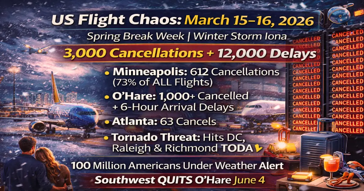
The Sunday numbers are historic: Minneapolis-St. Paul (MSP) posted 612 cancellations — 73% of every departing flight at the airport. The airport resembled a ghost town, with Fox 9 Minneapolis describing it as a scene of abandoned terminal concourses, 20+ inches of snow on the ground, and Governor Tim Walz deploying the National Guard. Chicago O’Hare saw over 1,000 flights cancelled — the highest single-day cancellation count at any US airport this Spring Break — with FAA arrival delays reaching 6 hours at their peak. More than 210,000 utility customers across six Great Lakes states lost power. And buried in the operational chaos, Southwest Airlines dropped a bombshell: it is permanently closing its O’Hare and Washington Dulles operations from June 4, 2026. Here is everything every US traveller needs to know right now.
Published: March 16, 2026 (Monday — Spring Break Day 3 | DHS Shutdown Day 32) Sunday March 15 total (FlightAware/Newsweek peak): ~3,000 cancellations + 12,000+ delays Minneapolis-St. Paul (MSP): 612 cancellations = 73% of ALL departing flights 👻 Chicago O’Hare (ORD): 1,000+ cancellations | FAA arrivals delayed 6 hours Chicago Midway (MDW): 100+ cancellations — ground stop active Atlanta (ATL): 63 cancellations + 30 delays — Delta worst carrier (49 cancels) US accounts for: 78% of ALL global cancellations on March 15 Total global cancellations March 15: 2,842 flights — 2,216 US 100 million Americans: Under weather alerts (ABC News, NWS) Storm name: Winter Storm Iona (named storm — bomb cyclone) Snow accumulation MSP/WI: 20+ inches in southeastern Minnesota, western Wisconsin TODAY (March 16): Tornado threat South Carolina → Maryland → DC → NY corridor Wind gusts today: Up to 74 mph — Washington D.C., Raleigh, Richmond Raleigh/Chapel Hill schools: CLOSED today ❌ NC Governor Josh Stein: Emergency alert issued — enable emergency notifications NOW Southwest Airlines: Permanently QUITTING O’Hare + Dulles from June 4, 2026 🚨 DHS Shutdown: Day 32 — 300+ TSA officers quit, unpaid workforce stretched Storm clears: Meteorologists expect system off East Coast by Wednesday evening “Second wave” travel: Thursday–Sunday relatively cleaner window
Winter Storm Iona is not a typical March snowstorm. This is a rapidly intensifying extratropical cyclone — commonly known as a bomb cyclone — that has undergone explosive deepening at a rate that surprised even seasoned meteorologists.
A bomb cyclone is formally defined as a low-pressure system whose central pressure drops at least 24 millibars in 24 hours. Storm Iona exceeded that threshold. The result is a storm with hurricane-force intensity dynamics — extremely strong pressure gradients, blizzard-force winds, and the ability to move massive precipitation bands across a wide geographic area in hours.
The storm is “currently slicing through the heart of the country, creating a polarized map of travel misery. While one half of the nation is digging out from under a foot of snow, the other is bracing for violent thunderstorms and flash floods.” The central United States was the eye of Sunday’s worst disruption. Today — Monday — that disruption is tracking east.
The simultaneous threats active this week:
✈️ Upper Midwest Blizzard (Sunday–Monday): Eastern South Dakota through Wisconsin into Michigan’s Upper Peninsula — 20+ inches of snow confirmed, roads impassable, NWS La Crosse warning: “Snow continues through noon, dangerous travel. Heavy snowfall rates of 1–2 inches per hour at times.”
✈️ Tornado/Severe Storm Corridor (TODAY, March 16): South Carolina through Maryland and D.C. — “severe thunderstorms with widespread damaging winds and several tornadoes” expected. Moderate risk zone confirmed by NWS. Raleigh, Richmond, Washington D.C. in the crosshairs.
✈️ Southeast/Gulf Severe Storms: Enhanced risk zone from Monroe, Louisiana through Indianapolis — “numerous extreme storms are possible.” Florida Panhandle, southeast Alabama and southwest Georgia also at enhanced risk for widespread damaging wind gusts, possible tornadoes and large hail.
✈️ West Coast Record Heatwave: Los Angeles approaching 90°F for the Oscars on Sunday; Phoenix and Tucson under Excessive Heat Watches through Friday. Southern California to San Luis Obispo corridor scorching. Las Vegas, Albuquerque, Palm Springs approaching or challenging daily records.
✈️ Hawaii Flooding Disaster: Maui Mayor Richard Bissen confirmed 20 inches of rain in 24 hours as of Friday. “We’re seeing flooding, landslides, sinkholes, debris and downed power lines across the county.” National Guard members and fire department made multiple floodwater rescues. Honolulu airport access compromised.
Minneapolis-St. Paul International Airport (MSP) on Sunday March 15 — the single worst-performing major airport in the United States this Spring Break season.
Minneapolis St. Paul Airport saw the largest number of cancellations, with 343 flights canceled Sunday morning, accounting for 73 percent of all flights departing from the airport. By end of day, the total rose to 612 cancellations and 18 delays — a figure that represents a near-total shutdown of Minnesota’s aviation gateway.
What 73% of all departing flights cancelled looks like on the ground:
The airport resembled a ghost town. Fox 9 Minneapolis broadcast live images of concourses that would normally be packed with Spring Break families completely emptied. Snow blanketed the tarmac and runways. Ground crews worked in near-zero visibility conditions. The Governor of Minnesota, Tim Walz, deployed National Guard units — not just for airport operation but for road clearing, stranded motorist rescue and emergency response across a state blanketed in over 20 inches of snow.
Delta Air Lines at MSP: Delta operates its Minneapolis hub as a primary upper-Midwest gateway. Delta’s statement on Sunday: “Airports in the Midwest, including Delta’s Minneapolis-St. Paul hub, continue to see snowfall and strong winds. We expect Delta flights to gradually resume once airport conditions improve. Delays and additional schedule adjustments are possible as operations recover.”
United Airlines waiver (MSP and Upper Midwest): United issued a travel waiver for passengers with affected flights from the Upper Midwest and Great Lakes region: “You can reschedule your trip and we’ll waive change fees and fare differences. Your new flight must be a United flight departing between March 12–20, 2026. Tickets must be in the same cabin and between the same cities as originally booked.”
Delta waiver extension: Delta had previously set a March 22 deadline for ticket reissuance — passengers can now extend this deadline to March 24, 2026.
For passengers with MSP departures today (March 16): ✈️ MSP is still recovering from Sunday’s near-shutdown — Monday morning departures carry a high risk of residual delay from crew and aircraft positioning disruption ✈️ Check delta.com, united.com, aa.com specifically for MSP status before leaving for the airport ✈️ Road conditions around MSP may still be hazardous — allow extra travel time to the airport
Chicago O’Hare International Airport — over 1,000 flights cancelled on Sunday, with FAA arrival delays peaking at 6 hours.
O’Hare International Airport has seen over 1,000 flights cancelled. Arriving flights at Chicago O’Hare International Airport early Sunday afternoon were already subject to delays of up to six hours due to weather, according to the FAA.
The scale of O’Hare’s disruption on Sunday is extraordinary even by this Spring Break’s already-chaotic standards. For context: O’Hare is the second-busiest airport in the United States by aircraft movements. On a normal March Sunday, it processes approximately 900–950 aircraft movements (arrivals + departures). A 1,000+ cancellation figure means that on Sunday, O’Hare processed well under half its normal volume — and the flights that did operate faced 6-hour arrival queuing.
At O’Hare, Envoy Air and SkyWest faced the largest cancellations, with 47 and 46 cancellations, respectively. The majority of these cancellations stemmed from SkyWest, a regional carrier, which had a high percentage of delayed flights as well. GoJet (a United Airlines subsidiary) also faced significant disruptions, contributing to the overall chaos. The cancellations at ORD particularly affected regional travel within the United States.
Chicago Midway (MDW): Also issued a ground stop. Over 100 cancellations confirmed. Southwest Airlines — which operates Midway as its primary Chicago hub — issued urgent travel advisories for passengers.
Today (March 16) — O’Hare outlook: ✈️ Thunderstorms in the Chicago area could turn to snow and whiteout conditions from Sunday night into Monday. ✈️ Winter Weather Advisory in place for Chicagoland until 1 PM Monday (WGN-TV confirmed) ✈️ ORD is still in recovery mode from Sunday — expect Monday morning delays of 2–4 hours above scheduled times for early departures
Buried in Sunday’s operational chaos, Southwest Airlines announced a decision that will permanently reshape Chicago aviation.
Southwest Airlines announced it will discontinue service to Chicago O’Hare International Airport (ORD) and Washington Dulles International Airport (IAD) effective June 4, 2026. The decision comes after five years of O’Hare operations that the airline described as “challenging” — and comes on the same weekend that O’Hare posted 1,000+ cancellations in a single day.
What this means:
✈️ O’Hare: Southwest will permanently close all O’Hare operations on June 4. Passengers with Southwest flights booked at O’Hare after June 3 will have their flights cancelled and must rebook at Chicago Midway (MDW) — Southwest’s primary Chicago hub — or request a full refund. ✈️ Dulles (IAD): Southwest permanently closes Dulles operations June 4. Washington D.C. passengers will need to use Reagan National (DCA) — where Southwest retains operations — or Baltimore-Washington (BWI). ✈️ For existing bookings at ORD or IAD after June 3: Southwest will contact affected passengers with rebooking options or refund offers. Check southwest.com for the latest or call 1-800-435-9792. ✈️ No impact on flights before June 4: If you have a Southwest flight at O’Hare or Dulles scheduled before June 4, 2026, your booking is unaffected.
The broader context: Southwest’s exit from O’Hare is a direct consequence of the FAA’s March 2026 capacity cap order — which mandated a reduction from 3,080 to 2,800 daily operations at O’Hare from March 29. Southwest, operating on thinner margins at O’Hare than United and American, chose to concentrate its Chicago operations at Midway rather than compete for reduced O’Hare slots. The June 4 departure timing — two months after the March 29 FAA cap takes effect — suggests this decision was already in progress before the weekend’s storm.
Hartsfield-Jackson International (ATL), a major hub for Delta, saw a total of 63 cancellations and 30 delays today. Delta was again the most affected airline, with a total of 49 cancellations, representing 3% of its flights. The delays here were less severe than at other airports, but the impact was still notable. Spirit, Southwest, and Frontier experienced some cancellations and delays, with Spirit being the most affected among low-cost carriers.
Atlanta’s 63 cancellations reflect the Southern arm of the storm system — severe thunderstorms tracking northeast through Georgia and the Carolinas. For Spring Break families booked on Delta out of Atlanta: Delta’s rebooking waiver is now extended to March 24.
Seattle-Tacoma International Airport recorded 26 flight cancellations and 140 delays, affecting several domestic and international routes. Delta Air Lines reported the highest number of cancellations with 22 flights canceled and 7 delayed. Alaska Airlines experienced the largest number of delays, with 66 flights delayed and 3 cancellations.
SEA’s disruptions are driven by West Coast weather patterns separate from the Iona system — but the ripple effect of cancelled ORD and MSP connections is spreading westward through Alaska and Delta’s transcontinental networks.
If Sunday was the Midwest’s nightmare, Monday is becoming the East Coast’s.
The storm threat was expected to enter the Appalachians, then move toward the East Coast, where “severe thunderstorms with widespread damaging winds and several tornadoes” were expected, the service said. A stretch from parts of South Carolina to Maryland appeared most likely to experience the greatest damaging winds Monday afternoon, the weather service said. That could include Raleigh, North Carolina, Richmond, Virginia and the nation’s capital. Officials said schools in Raleigh and Chapel Hill, North Carolina, would be closed Monday. Gov. Josh Stein urged residents to enable emergency alerts on their phones ahead of expected wind gusts of 74 mph.
What this means for East Coast airports TODAY:
✈️ Raleigh-Durham (RDU): Schools closed — expect severely reduced passenger throughput at RDU today. High wind gusts will reduce runway acceptance rates and may force temporary ground stops. ✈️ Reagan National (DCA) / Dulles (IAD) / BWI: Washington D.C. area airports are in the direct path of today’s highest-risk severe weather zone. American, United, Southwest and Delta all operate significant DCA/IAD capacity. ✈️ Charlotte (CLT): American’s second-largest hub is inside the enhanced risk zone. CLT serves as the primary connecting hub for the entire Southeast — disruptions here cascade nationally. ✈️ Richmond (RIC): Smaller airport, but directly inside the high-wind zone for this afternoon. ✈️ New York (JFK/LGA/EWR): The increased-risk zone extends north toward New York — thunderstorms possible in New England by Monday night. ✈️ Atlanta (ATL): Already disrupted yesterday; the enhanced risk zone for today’s Southeast portion covers northern Florida, southeast Alabama and southwest Georgia — all airports feeding into ATL.
Beyond the threat to lives and property, “whether it’s wind gusts from a squall line, blizzard or snow, or just wind because of the storm, you’re looking at several major airports being impacted,” said AccuWeather senior meteorologist Tyler Roys.
The latest update unfolded as airports continue to struggle during the partial government shutdown of the Department of Homeland Security (DHS) that has seen Transportation Security Administration (TSA) agents go without pay, disrupting travel operations across the country. Airports already warned of longer lines and potential flight delays as unscheduled absences increased and more than 300 TSA officers left their jobs since the partial shutdown began, according to CBS News.
Today is DHS Shutdown Day 32. TSA officers received their first zero-dollar paycheck on March 14. The combination of: ✈️ 300+ officers already resigned since the shutdown began ✈️ Escalating unscheduled absences after the zero-paycheck milestone ✈️ Spring Break peak demand — 171 million passengers March–April ✈️ Weather chaos driving thousands of passengers back through security checkpoints on rebooking
…is producing what TTW described today as a “bottleneck of epic proportions” at the intersection of security screening and weather rebooking queues.
4-hour arrival recommendation is now standard guidance from AirHelp for all major US hub airports this week. At Washington D.C., Raleigh, and Charlotte today specifically — which face both active tornado threat AND TSA staffing pressure — 5 hours before departure is the only safe recommendation.
Meteorologists expect the system to clear the East Coast by late Wednesday, potentially allowing for a “second wave” of successful travel for the latter half of the break.
The practical timeline for US travellers:
| Date | Conditions | Travel Recommendation |
|---|---|---|
| Mon Mar 16 | Tornado risk SC→MD, ORD/MSP recovering | 🔴 Highest risk day for East Coast airports |
| Tue Mar 17 | Cold front clears East Coast overnight | 🟠 Improving — check morning status |
| Wed Mar 18 | System fully off East Coast | 🟡 Mostly normal — some backlog residual |
| Thu Mar 19 | Clear across most US | 🟢 “Second wave” — best flying day of Spring Break |
| Fri–Sun Mar 20–22 | Clear but Spring Break demand still high | 🟡 Weather clear, airport crowding remains |
United Airlines: ✅ Waiver covers: Upper Midwest and Great Lakes region ✅ Rebook to: March 12–20, 2026 (same cabin, same cities) ✅ Change fees: Waived | Fare difference: Waived ✅ How: united.com or the United app — fastest
Delta Air Lines: ✅ Waiver covers: Minneapolis hub + Southeast/Midwest storm corridor ✅ Deadline extension: Originally March 22 → now March 24, 2026 ✅ How: delta.com or the Fly Delta app
American Airlines: ✅ Waiver covers: Charlotte, Atlanta, DFW, DC-area airports in storm path ✅ Check: aa.com/travel-alerts for your specific departure city ✅ How: aa.com or the American app
Southwest Airlines: ✅ No change fees on any Southwest fare (standard policy) ✅ Midway (MDW) passengers: waiver active for all affected Chicago dates ✅ O’Hare passengers: Use Midway as alternative for future bookings ✅ How: southwest.com or 1-800-435-9792
Spirit Airlines: ✅ Waiver active for storm-affected airports ✅ How: spirit.com or Spirit app
✅ ORD is in recovery mode — check united.com or aa.com before leaving home. Monday morning departures carry 2–4 hour residual delay risk. ✅ MDW: Winter Weather Advisory until 1 PM — Southwest departures may be compressed into afternoon banks. Check southwest.com. ✅ Southwest O’Hare → Midway pivot: If you had a Southwest ORD booking (now or future), Southwest is concentrating all Chicago operations at MDW from June 4. Book Midway going forward.
✅ MSP is still digging out — 20+ inches of accumulated snow, and runways require extensive clearing protocols before returning to full capacity. ✅ Delta (primary hub carrier): use the Fly Delta app for MSP status. Delta’s waiver is extended to March 24. ✅ Minnesota roads around MSP: still hazardous Monday morning. Allow additional travel time from the city.
✅ TODAY is the most dangerous day of the storm for DC-area airports. Tornado risk is moderate, 74 mph wind gusts possible this afternoon. ✅ Arrive 5 hours before departure today at DCA, IAD or BWI — TSA checkpoint pressure + weather rebooking queues + potential ground stops. ✅ If your flight shows “on time” this morning: do NOT reduce your airport arrival time. Ground stops can be issued with 30 minutes’ notice when severe weather approaches.
✅ Schools are CLOSED in Raleigh/Chapel Hill — road conditions hazardous. ✅ RDU is inside today’s highest-risk severe weather zone. Check rdu.com and the FAA NAS status page before leaving. ✅ American Airlines is RDU’s primary carrier — check aa.com specifically.
✅ American’s CLT hub sits inside the enhanced risk zone. CLT is also one of the most delay-sensitive connection airports in the US — when CLT gets a ground stop, its ripple effects reach coast-to-coast within 2 hours. ✅ PSA Airlines (American regional feeder at CLT): has posted high cancellation rates this Spring Break. Verify your feeder flight specifically.
✅ Step 1 — Check your flight status NOW at your airline’s app. Not the airport website. Not a third-party tracker. Push notifications from airline apps are 15–20 minutes faster than airport monitors during mass disruptions.
✅ Step 2 — If your flight is cancelled: use the airline waiver immediately. All major carriers have active waivers. Rebook via the app — phone queues today are hours long. The “Carry-On Only” rule: with 3,000+ Sunday cancellations cascading into Monday, checked bag misrouting risk is extreme. Pack carry-on if possible.
✅ Step 3 — East Coast passengers today: give yourself 5 hours. Tornado risk + TSA zero-paycheck day 2 + weather rebooking crowds = a checkpoint environment unlike anything seen this Spring Break.
✅ Step 4 — Know the “Rule 240″/DOT rights. Weather cancellations = free rebook or refund, no cash compensation owed. But if you persistently ask for hotel vouchers, many airlines will provide them as goodwill — especially United, Delta and American who have DOT commitments. Ask at the gate desk, not over the phone.
✅ Step 5 — Credit card trip delay/cancellation insurance. If you are stranded for 6+ hours, many premium travel credit cards (Chase Sapphire Reserve, AmEx Platinum, Capital One Venture X) provide up to $500 in food and lodging reimbursement per ticket. File the claim the day the delay occurs with all receipts.
Posted By : Vinay
Lastest News
2nd Floor, 39, Above Kirti Club, DLF Industrial Area, Kirti Nagar, New Delhi, Delhi 110015
Travel Tourister is a leading Travel portal where we introduce travellers to trusted travel agents to make their journey hasselfree, memorable And happy. Travel Tourister is a platform where travellers get Tour packages ,Hotel packages deals through trusted travel companies And hoteliers who are working with us across the world. We always try to find new and more travel agents and hoteliers from every nook and corners across the world so that you could compare the deals with different travel agents and hoteliers and book your tour or hotel with the one you have chosen according to your taste and budget.
Copyright © Travel Tourister, India. All Rights Reserved
 Call
Call Enquiry