Published on : 18 Sep 2026
By Travel Tourister | Updated Sep 2026
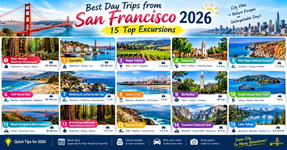
San Francisco’s geographic position — at the tip of a peninsula, surrounded on three sides by water, and situated at the intersection of the Pacific coast, the Bay Area’s wine country, and the Sierra Nevada’s gateway — makes it the single best day-trip hub in the United States. No other major American city provides the range of landscape types, cultural experiences, and natural wonders accessible within a two-hour radius: the ancient coast redwood forests of Muir Woods (17 miles), the Napa Valley vineyards (55 miles), the Pacific coastal drama of Point Reyes National Seashore (40 miles), the Mediterranean waterfront village of Sausalito (15 minutes by ferry), the Victorian coastal town of Half Moon Bay (28 miles), the Big Sur coastline beginning at Carmel (120 miles south), and the granite magnificence of Yosemite Valley (200 miles, best as an overnight but achievable as a long day trip from San Francisco).
The best day trips from San Francisco in 2026 require understanding several planning factors that significantly affect the experience: the specific transport options (car rental provides the most flexibility for coastal and wine country trips; the ferry to Sausalito and Angel Island is the most atmospheric approach to those destinations; the guided wine country tour eliminates the driving-while-tasting problem that self-guided Napa visits create), the seasonal considerations (Muir Woods is most atmospheric in the winter fog and the spring wildflower season; the Napa harvest [September–October] adds agricultural drama to the wine tasting; Point Reyes is most rewarding in March for elephant seal pupping and in January for the gray whale migration), and the reservation requirements (Muir Woods entry and parking must be booked at recreation.gov; many Napa wineries require advance tasting reservations; Yosemite Valley requires advance timed-entry permits May through September). This guide covers the 15 best day trips from San Francisco with the honest distance, transport, and planning detail that makes each genuinely achievable.
For complete San Francisco planning, see our Things to Do in San Francisco 2026, Places to Visit in San Francisco 2026, San Francisco Travel Guide 2026, and Best Time to Visit San Francisco 2026.
| Destination | Distance | Drive Time | Transport | Cost | Best Season |
|---|---|---|---|---|---|
| Muir Woods | 17 miles | 45 min | Shuttle/car | $18 entry + $3.75 shuttle | Year-round; winter fog |
| Sausalito | 15 min ferry | Ferry | Golden Gate Ferry | $14–$16 round-trip | Year-round |
| Angel Island | 30 min ferry | Ferry/Bike | Blue & Gold Fleet | $18 round-trip | Spring–Fall |
| Napa Valley | 55 miles | 1 hr 15 min | Car/tour | $50–$200+ (tastings) | Year-round; harvest fall |
| Sonoma County | 45 miles | 1 hr | Car | $40–$150 (tastings) | Year-round |
| Point Reyes NS | 40 miles | 1 hr 15 min | Car | Free (parking $35) | Year-round; March (seals) |
| Half Moon Bay | 28 miles | 45 min | Car/SamTrans | Free (beach) | Year-round; October (pumpkins) |
| Santa Cruz | 75 miles | 1 hr 30 min | Car | $15–$30 (Boardwalk) | Summer; Year-round |
| Carmel-by-the-Sea | 120 miles | 2 hrs | Car | Free to explore | Year-round |
| Big Sur | 150 miles | 2 hrs 30 min | Car | Free | Year-round |
| Yosemite Valley | 200 miles | 3 hrs 30 min | Car/bus | $35 park fee | Year-round; spring waterfalls |
| Berkeley | 14 miles | 30 min | BART | $6–$8 round-trip | Year-round |
| Oakland | 12 miles | 25 min | BART | $6–$8 round-trip | Year-round |
| Monterey | 115 miles | 1 hr 45 min | Car | $50 (Aquarium) | Year-round |
| Stinson Beach | 22 miles | 50 min | Car/bus | Free (beach) | Summer |
Distance: 17 miles north of San Francisco | Drive time: 45 minutes via US-101 and Panoramic Highway | Entry cost: $18 (adult, mandatory online reservation at recreation.gov) | Duration: 3–4 hours | Transport options: Muir Woods Shuttle ($3.75 from Sausalito Ferry Terminal); car (parking reservation also required) | Season: Year-round; most atmospheric October–April
Muir Woods National Monument (the old-growth coast redwood grove in the Redwood Creek watershed of the Marin County hills — 554 acres of trees reaching 78+ meters in height and 800+ years in age, designated a National Monument in 1908 at John Muir’s request to President Theodore Roosevelt) is the most immediately awe-inspiring natural experience within a half-day’s travel of San Francisco. The specific sensory quality of the Muir Woods experience — the 70-meter canopy filtering the light into a specific cathedral-green luminescence, the sound-dampening effect of the massive trunks and the moisture-saturated air creating an acoustic environment of extraordinary quietude, and the specific smell (the redwood bark’s natural terpene compounds creating the most distinctly Northern California forest fragrance available anywhere in the Bay Area) — is unlike any other accessible Northern California natural environment.
The Cathedral Grove: The section of the main trail approximately 0.6 miles from the entrance, where the oldest and tallest trees cluster — the Cathedral Grove’s specific scale (the largest trees reaching 260+ feet in height, the canopy 100+ feet above the trail surface) creating the most viscerally impressive single natural space in the Bay Area. The specific Cathedral Grove light (the filtered canopy light creating the distinctive green luminescence that Muir Woods photography specifically seeks) is most dramatic on overcast days (the diffused grey light creating more even illumination than the contrast-heavy direct sun) and in the morning (the lower angle adding additional drama).
Planning essentials:
Muir Woods + Sausalito combination: The most efficiently structured Muir Woods day trip — the Golden Gate Ferry from the Ferry Building to Sausalito (30 minutes, $14 round-trip, bay views throughout), the Muir Woods Shuttle from the Sausalito Ferry Terminal to Muir Woods (30 minutes, $3.75), the grove walk (2–3 hours), the shuttle return to Sausalito, and the Sausalito afternoon walk (the Main Street, the waterfront restaurants, the Bay Model Visitor Center) before the evening ferry return to San Francisco. A complete and specifically rewarding day without a rental car.
Distance: 40 miles north of San Francisco | Drive time: 1 hour 15 minutes via US-101 and Sir Francis Drake Boulevard | Entry cost: Free (parking $35 at the Bear Valley Visitor Center, or free at various trailheads) | Duration: Full day | Transport: Car required | Season: Year-round; March for elephant seals; January for gray whales
Point Reyes National Seashore (the 71,000-acre National Seashore on the Point Reyes peninsula — the geologically distinct landmass that rides on the Pacific Plate [while the adjacent mainland sits on the North American Plate], moving northward approximately 2 inches per year, the specific geological drama visible in the Earthquake Trail at the Bear Valley Visitor Center where the 1906 San Francisco earthquake’s fault trace is preserved in the landscape at a fence moved 16 feet laterally in 42 seconds) is the most dramatically varied single day-trip destination from San Francisco: the combination of the exposed Pacific coastline (the windswept bluffs at Point Reyes Headlands, the specific Pacific Ocean drama of the outer coast in full exposure to the open ocean), the pastoral dairy farming landscape (the historic D, E, and F Ranches whose 150-year-old dairy farming operations within the national seashore create the most specifically agrarian landscape of any California national park), and the wildlife encounters (the elephant seal colony at Drakes Beach — January through March for pupping, the largest elephant seal colony accessible from any major California city — and the gray whale migration visible from the Point Reyes Headlands lighthouse trail in January–April).
The Point Reyes Lighthouse (10 miles from Bear Valley Visitor Center, open Thursday–Monday): The most dramatically positioned single Point Reyes destination — the lighthouse at the very tip of the Point Reyes peninsula, the trail from the parking area descending 308 steps to the lighthouse at the cliff base, the wind at this specific exposed point (averaging 20+ mph, with gusts exceeding 60 mph on the stormiest days) creating the most viscerally Pacific weather experience available anywhere in the Bay Area. The lighthouse access staircase is closed in high winds (above 40 mph) — check the NPS Point Reyes website (nps.gov/pore) for the current day’s access status before the specific lighthouse descent is a priority.
Best Point Reyes seasonal experiences:
Distance: 22 miles from San Francisco | Drive time: 50 minutes (via Panoramic Highway through Mt. Tamalpais) | Entry cost: Free (day parking $10–$15 in peak season) | Duration: Half to full day | Transport: Car or Marin Transit bus (weekend service in summer) | Season: June–September for warmest water; year-round for the drive
Stinson Beach (the 3.5-mile Pacific Ocean beach in the Marin County community of Stinson Beach — the most accessible Northern California Pacific beach from San Francisco, the specific combination of the Mt. Tamalpais scenic drive approach [the winding two-lane road descending through the coastal redwoods to the beach, one of the most scenically dramatic approaches to any Northern California beach], the beach’s specific protected bay character [the Bolinas Lagoon to the south providing some protection from the open ocean’s direct energy], and the Stinson Beach community’s casual outdoor café culture) provides the most specifically Northern California beach day experience available from San Francisco: the Pacific Ocean swimming (warmest in July–August at 58–62°F/14–17°C — cold by Southern California standards but the warmest available on this stretch of coast, the specific Northern California cold-water swimming character significantly different from the warm-water alternatives that require a 6-hour drive south), the view north toward Point Reyes (the National Seashore’s headlands visible across the bay from the beach’s northern end), and the specific Stinson Beach village character (the Parkside Café, the Stinson Beach Bar, and the casual food service of a beach community that has remained genuinely un-commercialized relative to most California beach destinations).
The Mt. Tamalpais drive: The most scenically rewarding approach to Stinson Beach — the drive from Mill Valley (accessible by Golden Gate Ferry to Sausalito + bus) up the twisting two-lane Panoramic Highway through Mt. Tamalpais State Park, stopping at the Pantoll trailhead (the most accessible Mt. Tamalpais hiking access point, the trails to the summit providing the finest Bay Area hill walking at the mountain’s 2,571-foot high point) before descending the equally dramatic coastal side to Stinson Beach. The specific quality of the Panoramic Highway drive (the coastal redwood forest on the upper section, the Pacific Ocean appearing progressively as the descent toward the coast accelerates, and the Stinson Beach view appearing suddenly at the final descent curve) is the most specifically Northern California road-experience available within 1 hour of San Francisco.
Distance: 28 miles south of San Francisco | Drive time: 45 minutes via Highway 1 (Cabrillo Highway) or 35 minutes via I-280 + Highway 92 | Entry cost: Free | Duration: Half to full day | Transport: Car or SamTrans bus | Season: Year-round; October for pumpkins and the Mavericks surf
Half Moon Bay (the coastal San Mateo County city 28 miles south of San Francisco on Highway 1 — the agricultural community whose specific combination of the Pacific Coastal Highway setting [the driving approach from San Francisco via the coastal route being one of the most dramatic 45-minute drives available from any major American city], the historic Main Street downtown, the coastal trail [the Coastside Trail running the length of the city’s beach front], and the specific October pumpkin festival culture creates the Bay Area’s most accessible short coastal day trip) provides the most variety-per-distance ratio of any Bay Area day trip: the morning farmers market, the coastal trail walk, the beach lunch, and the pumpkin farm visit all achievable in a single Half Moon Bay day without rushed scheduling.
The Half Moon Bay Pumpkin Festival (October): The annual Art and Pumpkin Festival (held the third weekend of October — check miramarevents.com for 2026 exact dates) is the most specifically Half Moon Bay-identity event: the pumpkin weigh-off (the world heavyweight pumpkin championship, where growers from California and beyond compete with pumpkins exceeding 2,000 pounds — the current world record exceeding 2,700 pounds, the Half Moon Bay weigh-off the most prestigious single pumpkin competition in the United States), the festival street fair on Main Street, and the general October coastal atmosphere (the Pacific Ocean in its most dramatically storm-approaching October character, the coastal light at its most specifically atmospheric) create the most specifically seasonal single Bay Area day trip.
The Mavericks surf (winter): The Mavericks big-wave surf break (at Pillar Point, 2 miles north of Half Moon Bay) produces waves exceeding 60 feet during winter storms — the Mavericks surf break being one of the most dangerous and most spectacular big-wave surfing locations in the world, the specific underwater reef geometry amplifying the winter swells to the enormous height that makes Mavericks an annual surfing pilgrimage destination. The Mavericks Invitational (the invitation-only big-wave surf competition, held on a 24-hour notice when conditions are perfect — check maverickssurf.com for the current year’s event status) provides the most dramatically spectacular single Bay Area spectator sports experience when conditions trigger the event.
Distance: 55 miles northeast of San Francisco | Drive time: 1 hour 15 minutes (traffic-dependent; Friday afternoon traffic can extend to 2+ hours) | Winery tasting costs: $30–$80 per person per winery (3–4 tastings/day typical) | Duration: Full day | Transport: Car rental (recommended) or guided tour ($95–$150) | Season: Year-round; harvest September–October for agricultural atmosphere | Winery reservations: Essential at most Napa Valley wineries
Napa Valley (the 35-mile agricultural valley between the Mayacamas and Vaca mountain ranges, north of San Francisco via US-101 and Highway 37 or Highway 29 — the most internationally celebrated single American wine region, the Cabernet Sauvignon, Chardonnay, and Merlot productions from the Oakville, Rutherford, Yountville, and Stags Leap District appellations representing the most critically acclaimed California wine) is the most specifically California wine tourism experience: the vineyard-lined valley floor, the winery estates (from the modest family-farm tasting rooms to the architecturally significant purpose-built wineries like the Opus One [designed with specific wine-focused architecture], the Darioush [the Persian-influenced architecture), the Castello di Amorosa [the 121,000 square-foot 13th-century-style Tuscan castle built over 14 years at a cost of $30 million to produce Napa wine in a specifically theatrical medieval setting]), and the specific restaurant culture that has developed around the wine tourism economy (Yountville alone having more Michelin stars per capita than any other American city).
The Napa Valley wine circuit:
Yountville: The most specifically culinary-focused Napa Valley town — Thomas Keller’s French Laundry (the three-Michelin-star restaurant whose reservations open exactly 2 months ahead at 10 AM PST on the dot; the specific reservation-opening ritual of refreshing the Tock booking platform at 9:59:55 AM PST two months before the desired dining date being the most specific Bay Area competitive food experience), Bouchon Bistro (the more accessible Keller property, excellent food at significantly lower reservation intensity), and the various other fine-dining options (Ad Hoc, The Inn at Little Washington’s Napa outpost, and the various Yountville restaurants whose Michelin-star density makes the village a serious restaurant destination independent of the wine).
The Stags Leap District: The most historically significant single Napa appellation — the District that produced the Stag’s Leap Wine Cellars Cabernet Sauvignon that won the 1976 Paris Tasting (the blind tasting in which California wines defeated the finest French Bordeaux and Burgundy in French judges’ rankings, the event that established California wine’s international credibility and changed the global wine market permanently). Stag’s Leap Wine Cellars offers estate tours and tastings — reservations at cask23.com.
Oxbow Public Market (Napa): The food market in the Napa city center — the most specifically food-market Napa Valley experience without a restaurant reservation, the various producers (the COPIA wine shop, the Ritual Coffee, the C Casa taqueria, and the various other Oxbow vendors) providing the most accessible artisan-food Napa morning experience.
The transport problem: The single most practically important Napa planning consideration — driving while tasting is both illegal and dangerous, and many Napa visitors underestimate how quickly multiple winery tastings accumulate blood alcohol. The three solutions: a designated driver (the “DD” rotation), a guided wine country tour (various operators offer daily tours from San Francisco — check viatorcom or the SF Visitor Center for current 2026 operators, pricing typically $95–$150/person including transport and selected winery visits), or a Napa ride-share service (Napa-based car services that provide winery-to-winery transportation without a designated driver requirement, approximately $50–$80/hour).
Distance: 45 miles north of San Francisco | Drive time: 1 hour via US-101 | Tasting costs: $20–$60 per person per winery | Duration: Full day | Transport: Car | Season: Year-round | Character: Less formal than Napa, more diverse wine styles
Sonoma County (the wine-producing county north of San Francisco via US-101 and Highway 116 or Highway 12 — the most geographically diverse single California wine county, containing within its 1,768 square miles the Russian River Valley [Pinot Noir and Chardonnay], the Dry Creek Valley [Zinfandel], the Sonoma Coast [the coldest and most challenging Pinot Noir appellation in California], and the Alexander Valley [Cabernet Sauvignon] as distinctly different wine-producing sub-regions) provides the most varied single wine country day trip available from San Francisco — less formally structured than Napa Valley, generally more affordable, and typically more welcoming of walk-in tasting visitors (the majority of Sonoma County wineries accepting walk-in visitors rather than requiring advance reservations, though weekends in peak season benefit from prior contact).
Healdsburg: The most specifically wine-focused single Sonoma County town — the plaza (the central square surrounded by wine-focused retail, restaurants, and tasting rooms from the most celebrated Sonoma County producers), the SHED (the food and culture venue on the Foss Creek where the Healdsburg farmers’ market and various food-culture events concentrate), and the surrounding Dry Creek Valley (the 16-mile valley of Zinfandel vineyards — the most specifically Sonoma County single wine variety, the Dry Creek Zinfandel’s specific jammy-and-spicy character distinguishing it from the more restrained international Zinfandel equivalents).
Bodega Bay and the Sonoma Coast: Adding the Bodega Bay coastal stop (the small Pacific fishing community where Alfred Hitchcock filmed “The Birds” in 1962 — the Tides Wharf restaurant where the film’s most celebrated attack scenes were filmed, the surrounding landscape essentially unchanged from the film’s setting) and the Sonoma Coast State Park’s dramatic Pacific clifftops to a Sonoma County wine day creates the most varied single Northern California day trip — wine country + dramatic coast in a single circuit.
Distance: 15 minutes by ferry | Ferry cost: $14–$16 round-trip (Golden Gate Ferry from the Ferry Building) | Duration: Half day | Transport: Ferry (primary recommendation) | Season: Year-round
Sausalito (the affluent Marin County waterfront town directly across the Golden Gate — 15 minutes by ferry, providing the most specifically bay-transit-framed approach to any Bay Area destination) is the most efficiently enjoyable San Francisco day trip: the ferry departure from the Ferry Building (the bay-crossing providing the best moving views of the city skyline from the water surface), the Sausalito waterfront walk (the Main Street restaurants, galleries, and the houseboats visible north of the marina), and the specific Sausalito village character (the Mediterranean hillside residential architecture, the yacht harbor, and the distinct absence of chain retail creating a specifically affluent-small-town atmosphere).
What makes the ferry essential: The Sausalito approach by Golden Gate Ferry (rather than by car or bus over the Golden Gate Bridge) provides the most specifically scenic approach — the San Francisco skyline visible throughout the departure, the Golden Gate Bridge appearing in profile as the ferry rounds the headlands, and the Sausalito harbor appearing as the destination with the Marin hills behind it. By car, the same destination is 20 minutes of traffic; by ferry it’s 15 minutes of bay scenery and the specific pleasure of arriving by water.
Distance: 75 miles south of San Francisco | Drive time: 1 hour 30 minutes via Highway 17 | Entry cost: Free to explore; $15–$30 (Santa Cruz Beach Boardwalk) | Duration: Full day | Transport: Car or Greyhound/Santa Cruz Metro | Season: Summer for swimming; year-round for surf culture
Santa Cruz (the beach city 75 miles south of San Francisco on the Monterey Bay — the California beach town whose specific combination of the 1907 Beach Boardwalk [the last remaining major amusement park on the West Coast, the Giant Dipper wooden roller coaster from 1924 being the park’s most specifically historic single ride], the UC Santa Cruz campus in the redwoods above the city, the downtown Pacific Avenue commercial strip, and the Steamer Lane surf break [the most consistently photographed single surf location on the Northern California coast]) provides the most complete single California beach day available within 2 hours of San Francisco.
The Santa Cruz Surfing Museum (Lighthouse Point, free): The small museum in the Mark Abbott Memorial Lighthouse documenting California surfing history from the early 20th century — the specific Northern California surf culture history (the Santa Cruz area’s role in developing cold-water surfing, the wet suit’s development as a cold-water solution, and the specific Steamer Lane surf break’s role in Northern California surf competition history) providing the most specifically surf-culturally contextualizing single Santa Cruz attraction.
The Mystery Spot (1953 Branciforte Drive, $8): The Santa Cruz tourist attraction famous since the 1940s — the specific site where gravity appears to behave unusually (the trees growing at angles, the optical illusions of people appearing to be different heights in different positions) that has been entertaining visitors since 1939. The Mystery Spot is a carefully designed collection of optical illusions rather than an actual gravitational anomaly — but the specific theatrical delivery of the attraction’s ranger-performed show makes it one of the most specifically amusing paid tourist experiences in Northern California.
Distance: 120 miles south of San Francisco | Drive time: 2 hours via US-101 or Highway 1 | Entry cost: Free (Carmel town); $12.25 (17-Mile Drive entry fee) | Duration: Full day | Transport: Car | Season: Year-round
Carmel-by-the-Sea (the affluent Monterey Peninsula village — the fairy-tale cottage architecture, the white-sand Carmel Beach, the mission history [the Carmel Mission Basilica from 1770, the burial site of Father Junipero Serra and one of the most architecturally significant Spanish Mission buildings in California], and the specific Carmel village character [no streetlights, no sidewalks, no buildings with street numbers — the specific zoning regulations that have maintained Carmel’s village character by prohibiting the commercial signage and infrastructure that would make it resemble any other California coastal town] create the most specifically picturesque single California coastal village) and the 17-Mile Drive (the scenic private road through the Del Monte Forest and the Pebble Beach golf courses, the “Lone Cypress” [the single Monterey cypress on a granite outcrop above the ocean, the most specifically reproduced single image of the Monterey Peninsula] accessible from the 17-Mile Drive route) together constitute the most classically beautiful single Northern California coastal day trip available from San Francisco.
Practical Carmel planning: The 2-hour drive from San Francisco (via either US-101 through San Jose and then Highway 17 to Santa Cruz and Highway 1 south, or directly on US-101 to Salinas then west to Monterey) arrives in Carmel most conveniently by 10 AM for a full day — the morning Mission visit, the 17-Mile Drive, the Carmel Beach afternoon, and the Carmel village dinner (the Casanova restaurant and the Anton & Michel restaurant among the most specifically Carmel-character dining experiences) fitting comfortably in a single day with a 7–7:30 AM San Francisco departure.
Distance: 200 miles east of San Francisco | Drive time: 3 hours 30 minutes to 4 hours | Entry cost: $35 (vehicle pass, valid 7 days) | Duration: Full day (very long) | Transport: Car (primary); YARTS bus from Merced | Season: Year-round; May–June for waterfalls; avoid July–August weekends | Timed entry permits: Required May–September (recreation.gov)
Yosemite Valley (the 7-mile long glacial valley in the Sierra Nevada — the El Capitan granite monolith [at 2,897 feet the world’s largest exposed granite face], the Half Dome profile [the iconic granite dome whose vertical north face and distinctive rounded profile have made it the most recognized single geological formation in the United States], the Yosemite Falls [the highest waterfall in North America at 2,425 feet total drop], and the specific concentrated grandeur of the valley floor) is the single most dramatically beautiful natural destination accessible as a day trip from San Francisco — though the 200-mile distance and the 3.5-hour drive make it a genuinely long day that most visitors would more comfortably experience as an overnight.
Yosemite as a day trip — the honest assessment: The Yosemite Valley day trip from San Francisco (7 AM departure from SF, 10:30–11 AM valley arrival, 3–4 hours in the valley, 3:30–4 PM departure, 7–8 PM San Francisco return) is achievable but exhausting — the 7-hour round-trip driving for 3–4 hours of valley time creates a day that most visitors retrospectively wish they’d extended into an overnight at Yosemite Valley Lodge or in Curry Village. For visitors with only one available day, the day trip is worth the fatigue; for anyone who can arrange two days, the overnight is strongly recommended.
The May–June waterfall peak: The Yosemite waterfalls (Yosemite Falls, Bridalveil Fall, Nevada Fall, Vernal Fall, and various others) are at their maximum volume in May and June when the Sierra snowmelt is at its peak — the specific May–June Yosemite character (the waterfalls at maximum flow, the valley meadows green from the spring moisture, and the snow still visible on the upper valley walls creating the most dramatically varied single natural composition) is the most specifically rewarding single day-trip timing for the Yosemite Valley visit.
Timed-entry permits (May–September): The NPS timed-entry reservation system (recreation.gov — permits open approximately 2 months ahead for the specific entry window) is required for Yosemite Valley access during peak season. Without a timed-entry permit, vehicles are turned away at the entrance. Book immediately when the reservation window opens for the specific date — the most popular dates (July 4th weekend, Memorial Day, Labor Day) sell out within minutes of the window opening.
Distance: 14 miles east of San Francisco | Drive time: 30 minutes or 20 minutes by BART | BART cost: $6–$8 round-trip | Duration: Half to full day | Transport: BART (recommended) | Season: Year-round
Berkeley (the East Bay city directly across the Bay Bridge from San Francisco — the home of UC Berkeley [the most highly ranked public university in the United States, the specific academic culture permeating every aspect of the city’s intellectual and commercial character] and the Telegraph Avenue counterculture commercial district) provides the most specifically intellectual single Bay Area day trip: the UC Berkeley campus (the free-access campus visit including the Sather Tower [the 307-foot campanile, free to the observation gallery for UC students and $5 for non-students, the bay view from the top including San Francisco, the Golden Gate, and the Marin Headlands simultaneously], the Bancroft Library’s special collections, and the specific collegiate architecture), the Berkeley Rose Garden (the Municipal Rose Garden in the residential Northbrae neighborhood, 3,000 rose plants in a terraced setting overlooking the bay — the most specifically spectacular single Bay Area public rose collection), and the Gourmet Ghetto (the North Shattuck Avenue food corridor — the neighborhood that produced Chez Panisse [Alice Waters’ pioneering farm-to-table restaurant, the single most influential restaurant in the history of American cooking, operating since 1971 at 1517 Shattuck Avenue] and the surrounding artisan food ecosystem that Waters’ success inspired).
Chez Panisse: The single most historically significant restaurant in American food history — the restaurant where Alice Waters created the farm-to-table movement (the specific commitment to seasonal, local, organic ingredients and the relationship with specific Northern California farms that Waters established in 1971 and that has influenced every significant American restaurant opened since). The downstairs restaurant (prix-fixe, 1 sitting per evening, approximately $125–$150/person before wine and service — reservations required at chezpanisse.com, opening one month ahead for the specific date) and the upstairs café (à la carte, walk-ins accepted for lunch, more accessible pricing at $25–$45/person for lunch) provide two different access points to the most historically important single California restaurant.
Distance: 12 miles east of San Francisco | Drive time: 25 minutes or 20 minutes by BART | BART cost: $6–$8 round-trip | Duration: Half to full day | Transport: BART (recommended) | Season: Year-round
Oakland (San Francisco’s more specifically diverse and less internationally celebrated neighbor — the city that San Francisco’s housing costs have pushed the Bay Area’s working artists, musicians, and food entrepreneurs toward, creating the most specifically culturally dynamic single Bay Area alternative to San Francisco’s increasingly polished tourist-facing character) provides the most honest single Bay Area cultural day trip: the Oakland Museum of California (the most comprehensively California-focused single museum in the state — the natural sciences, history, and art collections organized around California’s specific cultural and natural history rather than the universal encyclopedic format that most museums adopt), the Jack London Square waterfront (the renovated Oakland estuary commercial district named for the author who grew up in Oakland and set his most celebrated work in the Alaska Gold Rush), and the Temescal and Grand Lake neighborhoods (the most specifically artisan-food and independent-retail Oakland neighborhoods, the farmers market, the coffee shops, and the restaurants representing the Bay Area’s most dynamic current food scene outside of San Francisco’s most expensive addresses).
Distance: 30 minutes by ferry from Pier 41 | Ferry cost: $18 round-trip (Blue & Gold Fleet) | Entry cost: $5 (state park entry) | Duration: Half to full day | Transport: Ferry (only option) | Season: April–October (peak); year-round service
Angel Island (the 740-acre island in San Francisco Bay — the largest Bay Area island, the former US Army post and immigration station [the West Coast equivalent of Ellis Island, where 1 million Asian immigrants were processed 1910–1940 under the specific restrictive conditions of the Chinese Exclusion Act and the subsequent immigration laws that Angel Island’s specific history represents], and now a State Park accessible only by ferry) provides the most specifically varied single Bay Area island day: the history (the Immigration Station [the most important West Coast immigration history site, the poetry carved into the barrack walls by detained Chinese immigrants during the exclusion era being the most specifically historically charged single Angel Island artifact], the military fortifications [the Treadwell fortifications, the Missile Battery, and the various Army installations dating from the Civil War through the Cold War], and the ecology (the island’s specific plant communities [the restored native grassland, the coastal scrub, and the eucalyptus groves] and the specific bay-environment wildlife [the harbor seals visible at the bay-facing beaches, the resident deer, and the various resident and migratory birds]).
The Angel Island perimeter bike/hike: The 5-mile road that circles the island’s perimeter (accessible by the bike rental at the Ayala Cove ferry landing, $15/hour) provides the most complete single-day Angel Island experience — the 360-degree bay panorama (San Francisco, Marin, Berkeley, and Oakland all visible simultaneously from the island’s various elevated positions along the perimeter road) and the historical sites all accessible in a single 2–3 hour circuit.
Distance: 115 miles south of San Francisco | Drive time: 1 hour 45 minutes via US-101 to Highway 68 | Entry cost: $50–$60 (Monterey Bay Aquarium) | Duration: Full day | Transport: Car | Season: Year-round
Monterey (the historic California capital — the most historically significant single California city during the Spanish and Mexican periods, the capital of Alta California from 1776 to 1846 and the location of the 1849 California Constitutional Convention [the meeting that established California’s constitution immediately before statehood, held at Colton Hall on the Monterey plaza]) provides the most comprehensively historical single day trip from San Francisco: the Monterey Bay Aquarium (the single finest aquarium in the United States, the open ocean tank [the billion gallons of Monterey Bay accessible through the aquarium’s open seawater system providing the most authentic marine habitat display at any American aquarium], the kelp forest tank, and the specific Monterey Bay ecosystem presentation that reflects the aquarium’s specific founding purpose [protecting and presenting the Monterey Bay’s specific biological richness, the bay being one of the most productive marine ecosystems in the Pacific]), the Cannery Row (John Steinbeck’s setting for the novel of the same name — the former sardine canning district now converted to tourist commercial use, the historical character visible in the old cannery buildings and the Steinbeck memorial while the contemporary use is almost entirely tourist-facing), and the 17-Mile Drive (accessible from the Carmel Gate, conveniently combined with a Monterey day if returning to San Francisco via Highway 1 north through Carmel).
The Monterey Bay Aquarium: The most specifically worthwhile single Monterey destination — the aquarium’s founding philosophy (the specific Monterey Bay ecosystem focus, the live animal exhibits [the sea otters in the Great Tide Pool, the various tank displays using actual bay water with its native marine life rather than the generalized “ocean” content that most aquariums display], and the specific educational approach [the aquarium was founded by the co-founders of Apple Computer as an educational and conservation institution rather than primarily an entertainment venue]) creates the most specifically mission-driven single California aquarium experience.
Distance: 150 miles south of San Francisco | Drive time: 2 hours 30 minutes to 3 hours via US-101 and Highway 1 | Entry cost: Free (most Big Sur areas); $10 (Pfeiffer Big Sur State Park day use) | Duration: Full day | Transport: Car | Season: Year-round (check highway conditions — landslides periodically close sections of Highway 1) | Highway 1 status: Always check Caltrans (dot.ca.gov/travel) before driving — the coastal highway is subject to seasonal closures
Big Sur (the 90-mile stretch of the California coast between Carmel and San Simeon — the Santa Lucia Mountains rising 5,000+ feet directly from the Pacific Ocean, the specific compressed topography that created the engineering challenge that the 1937 completion of Highway 1 resolved and that continues to create the landslide-susceptibility that periodically closes sections of the road) is the most dramatically beautiful single stretch of American coastal landscape accessible by road and the most specifically California-iconic single day trip available from San Francisco.
The essential Big Sur stops:
Bixby Creek Bridge (13 miles south of Carmel): The most photographed single architectural element of Highway 1 — the 1932 open-spandrel concrete arch bridge spanning the Bixby Creek canyon, the 260-foot arch visible from both the highway and the adjacent dirt road that provides the specific elevated view of the bridge with the Pacific below. The specific Bixby Creek Bridge composition (the bridge in the foreground, the Big Sur coastline extending southward, and the Pacific in the background) is the most reproduced single California highway photograph.
Pfeiffer Beach (turns off Highway 1 at Sycamore Canyon Road, 8.5 miles south of Pfeiffer Big Sur State Park entrance): The most specifically dramatic single Big Sur beach — the purple-sand beach (the manganese garnet minerals from the eroding Santa Lucia Mountains mixing with the quartz sand creating the specific purple tinge visible in certain lighting conditions), the Keyhole Arch (the sea-stack rock formation with the natural archway through which the setting sun shines directly in December and January, creating the most specifically photogenic single California beach sunset condition), and the general isolation (the 2.3-mile narrow dirt road access limiting the visitor volume to the specific commitment level that the road demands).
McWay Falls (Julia Pfeiffer Burns State Park): The most specifically iconic Big Sur natural feature — the 80-foot waterfall falling directly onto the beach and into the Pacific Ocean (one of only two tidefall waterfalls in California), visible from the Overlook Trail at the state park ($10 day use). The specific McWay Falls composition (the falls visible from above, the beach below, and the blue Pacific beyond) is the most reproduced single Big Sur landscape image.
About Travel Tourister Travel Tourister’s destination specialists have completed every day trip in this guide from San Francisco — from Muir Woods Cathedral Grove first-shuttle morning solitude and Napa Stag’s Leap tasting room historic visits through Point Reyes lighthouse February whale-watching positions and Sausalito ferry Golden Gate Bridge profile approaches to Yosemite Valley May waterfall-peak dawn valley walks, Big Sur Pfeiffer Beach purple-sand keyhole arch sunset sessions, Carmel Mission Serra burial site meditations, and Angel Island perimeter bike immigration station historical encounters — to deliver the most practically calibrated and most honestly assessed San Francisco day trip guide for 2026.
Posted By : Vinay
Latest Article
2nd Floor, 39, Above Kirti Club, DLF Industrial Area, Kirti Nagar, New Delhi, Delhi 110015



Travel Tourister is a leading Travel portal where we introduce travellers to trusted travel agents to make their journey hasselfree, memorable And happy. Travel Tourister is a platform where travellers get Tour packages ,Hotel packages deals through trusted travel companies And hoteliers who are working with us across the world. We always try to find new and more travel agents and hoteliers from every nook and corners across the world so that you could compare the deals with different travel agents and hoteliers and book your tour or hotel with the one you have chosen according to your taste and budget.
Copyright © Travel Tourister, India. All Rights Reserved

 Call
Call Enquiry