Published on : 23 Oct 2026
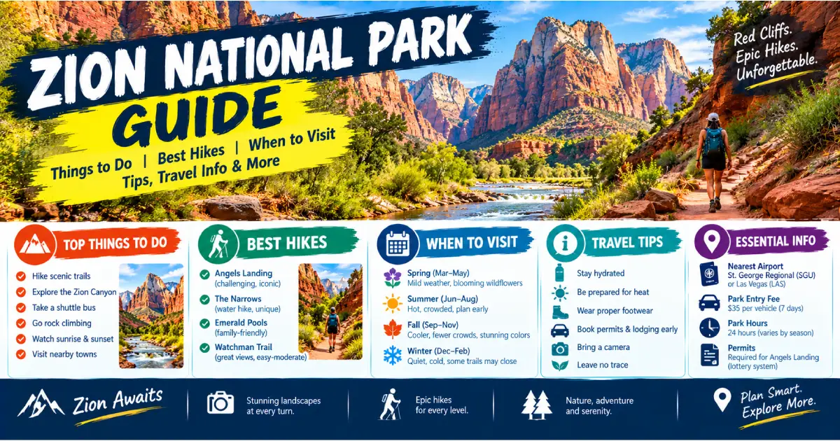
Zion National Park is the most visited national park in the American Southwest and one of the most visited in the United States — 4.7 million visitors in 2024, concentrated into a single canyon that is roughly 15 miles long and averages less than half a mile wide. The park protects 229 square miles of sandstone canyon country in southwestern Utah, centered on Zion Canyon, where the Virgin River has spent 13 million years cutting through the 2,000-foot-thick Navajo Sandstone to produce the sheer, polished, rust-and-cream canyon walls that make Zion one of the most photographed landscapes in North America. The walls of Zion Canyon rise 2,000 feet directly from the canyon floor in places; the canyon itself is narrow enough that the river fills most of its width at high water; and the contrast between the bleached white sandstone heights and the cottonwood-lined river bottom is as dramatic as any landscape in the American West.
What makes Zion distinctive among the great canyon parks — compared to the Grand Canyon to the south, Bryce Canyon to the east, and Canyonlands and Arches to the northeast — is the intimacy of the experience. The Grand Canyon is experienced primarily from the rim, looking down 5,000 feet at a canyon floor that most visitors never reach. Zion Canyon is experienced from the bottom, walking up the canyon floor as the walls close in above you, fording the Virgin River on the Narrows hike through a slot canyon so tight that your shoulders can touch both walls simultaneously, or hanging from an anchor on Angels Landing staring straight down at the canyon floor 1,488 feet below. The scale is comprehensible in a way that the Grand Canyon’s scale is not — and the trails place you directly in the landscape rather than at a viewpoint above it.
The park also has an extraordinary range of experiences beyond Zion Canyon proper. The Kolob Canyons section in the northwest corner of the park is almost entirely free of the crowds that characterize Zion Canyon and preserves a separate drainage of red-rock finger canyons with their own distinct character. The Kolob Arch — accessible via a 14-mile round-trip trail — is one of the largest free-standing natural arches in the world. The East Side of the park (accessible via the Zion–Mount Carmel Highway) is a landscape of slickrock domes and checkerboard mesa surfaces utterly unlike the vertical canyon walls of the main canyon. Zion’s ecological range — from the Mojave Desert species of the lower canyon to the ponderosa pine forest of the East Rim — adds another dimension to a park that rewards multiple days of exploration.
| Factor | Details |
|---|---|
| Location | Southwestern Utah, 2.5 hours north of Las Vegas |
| Size | 229 square miles (146,597 acres) |
| Established | November 19, 1919 |
| Elevation Range | 3,666 feet (southern entrance) to 8,726 feet (Horse Pasture Plateau) |
| Main Entrance | South Entrance (Springdale, UT) |
| Other Entrances | East Entrance (Zion–Mt. Carmel Hwy), Kolob Canyons (I-15 Exit 40) |
| Gateway Town | Springdale, UT |
| Annual Visitors | ~4.7 million |
| Entry Fee | $35/vehicle (valid 7 days); $30/motorcycle; $20/individual (foot/bike) |
| Annual Pass | America the Beautiful Interagency Pass, $80 |
| Shuttle Required | Yes — private vehicles prohibited on Zion Canyon Scenic Drive, April–November |
| Best Season | March–May, September–November |
| Website | nps.gov/zion |
The most common gateway — fly into Las Vegas (LAS) and drive north on I-15 to St. George, Utah, then UT-9 east to Springdale and the South Entrance. Allow 2.5–3 hours. Las Vegas car rentals are abundant and competitively priced; this is the standard approach for most domestic and international visitors.
I-15 south through Provo and Cedar City to the Kolob Canyons exit (I-15 Exit 40) or continue to St. George and UT-9 east to the South Entrance.
UT-9 east from I-15 through Hurricane and La Verkin to Springdale. St. George has its own regional airport (SGU) with service from Salt Lake City, Phoenix, Los Angeles, Denver, and Dallas.
The most scenic approach — UT-12 west from Bryce Canyon to US-89 south to UT-9 west. This route passes through Red Canyon (a miniature Bryce Canyon with free roadside access) and the Sevier River valley.
US-89 north from Page to Kanab, UT, then US-89 west to UT-9 north.
Multiple shuttle services operate between Las Vegas/Las Vegas airport and Springdale, including St. George Shuttle (stgshuttle.com) and various park-tour operators. One-way fares $40–65/person. Reservation required.
Private vehicles are prohibited on the Zion Canyon Scenic Drive from the south entrance to the Temple of Sinawava from April through November — the most significant park management policy in the American national park system. All visitors park in Springdale (free parking available throughout town) or at the Visitor Center parking area and ride the free shuttle. The shuttle has 9 stops from the Visitor Center to the Temple of Sinawava (end of the road, Narrows trailhead); buses run every 7–10 minutes at peak times and every 15–20 minutes in shoulder season.
Springdale shuttle: A separate free shuttle connects Springdale hotels and the town to the park entrance; the combined Springdale + Zion Canyon shuttle system means a car is unnecessary once you arrive at your Springdale hotel.
Outside April–November: Driving the Zion Canyon Scenic Drive in your own vehicle is permitted in winter (December–March), when the shuttle does not operate. The road is plowed; normal passenger vehicles are adequate except after heavy snowfall.
The 24.5-mile highway crossing the park east–west — from the South Entrance to the East Entrance — is driveable year-round in personal vehicles with one restriction: oversized vehicles (RVs, trailers, and vehicles over 7’10” wide or 11’4″ tall) must pay a $15 tunnel escort fee and be escorted through the 1.1-mile Zion–Mount Carmel Tunnel. The tunnel is one-way for oversized vehicles; escorts available daily. Bicycles and pedestrians may not use the tunnel; bikes travel on the shuttle.
Angels Landing is the most famous hike in Zion and one of the most famous in the American West — a 5.4-mile round-trip to a narrow sandstone fin at 5,790 feet above the canyon floor, with the final half-mile along a ridgeline using chains bolted into the rock where the trail narrows to a few feet with 1,000+ foot drops on both sides. Six people have fallen to their deaths on Angels Landing since 1998; the permit requirement (introduced in 2022) reduced the dangerous overcrowding that characterized the route in peak years.
The route: The West Rim Trail from The Grotto climbs 21 switchbacks (the “Walter’s Wiggles” — the finest piece of trail engineering in the park, a series of 21 tight zigzag switchbacks on a sheer sandstone wall) to Scout Lookout, a broad terrace at 5,495 feet with full canyon views. The permit gate is here; only permit holders proceed beyond Scout Lookout on the final half-mile chain route.
Permit strategy: Two permit windows — a seasonal advance lottery (opens 5 months before the intended visit month; apply at recreation.gov in the month prior) and a day-before lottery (opens at noon the day before; good for spontaneous travelers). The advance lottery is competitive; the day-before lottery is moderately competitive and is worth attempting if you did not win the advance lottery. Do not attempt the final section without a permit — rangers check permits at Scout Lookout.
Safety: Descending is more dangerous than ascending — the chains require careful footwork, and hikers descending pass hikers ascending on a narrow ridgeline. Wet rock is extremely dangerous; do not attempt in rain or immediately after rain. Morning start (before 8 AM) avoids the peak-heat hours and reduces chain congestion.
The Narrows is Zion’s signature experience and one of the finest slot canyon hikes in the world — a route through the Virgin River itself, walking in and through the water for the majority of the hike, between canyon walls that close to 20 feet apart at the narrowest sections and rise 1,000 feet overhead. The bottom-up day hike from the Temple of Sinawava is among the most accessible of Zion’s major hikes — no permit required for day use, the trailhead is the last shuttle stop, and the route up-canyon can be as short or as long as the hiker wishes.
Gear: Waterproof shoes or canyoneering sandals (Tevas or Chacos are adequate in summer), a walking stick (trekking poles with rubber tips removed), and neoprene socks in spring/fall (water temperature in March–May can be 40–55°F). Rental gear (dry pants, neoprene socks, walking sticks) is available from outfitters in Springdale ($20–40/day): Zion Adventure Company (Zion Outfitter, 36 Lion Blvd) and Zion Rock and Mountain Guides (1458 Zion Park Blvd).
Water level: Check current conditions before entering. Flash flood danger is serious — a storm anywhere in the watershed can produce a flood in the Narrows within 30 minutes without rain at the canyon. Check the NPS flash flood potential forecast at nps.gov/zion/planyourvisit/thenarrows.htm; do not enter when flash flood potential is listed as “high.” Flash floods in the Narrows have killed hikers; this warning is not precautionary.
Best conditions: Late June through September for warmest water (65–75°F, wade-able without neoprene); May and October for lower visitor counts and manageable water temperatures with rental gear.
Mystery Canyon: The finest technical canyoneering entry into the Narrows — a full-day guided rappel descent from the canyon rim to the Narrows, joining the route at a dramatic waterfall. Guided trips from Zion Adventure Company ($250–300/person); full-day commitment.
The Emerald Pools trail system is the most family-friendly major hike in Zion — a series of three tiered hanging gardens and pools fed by seeps from the canyon wall, connected by progressively more demanding trail segments. The Lower Pool walkway passes beneath a 100-foot cliff face where water seeps from the sandstone, creating a hanging garden of maidenhair fern and columbine directly behind the trail (visitors walk through the spray from a wet season drip). The Middle Pool is the most photogenic — a clear green pool reflecting the canyon walls above. The Upper Pool requires the full 3-mile round-trip and 650-foot climb but rewards with solitude relative to the lower pools and long views down Zion Canyon.
The most underrated easy hike in Zion — a 1-mile route through potholes, slickrock, and hanging gardens east of the tunnel, ending at an overlook 1,000 feet directly above the Great Arch of Zion and the Pine Creek canyon below. The Great Arch is one of the largest blind arches (recessed alcove rather than true free-standing arch) in Utah, visible only from above and from the road; the Canyon Overlook is the finest viewpoint. The hike involves some uneven rock steps and a single narrow ledge section, but is manageable for most visitors.
Practical: The Canyon Overlook trailhead is on the east side of the Zion–Mount Carmel Tunnel and is not served by the shuttle (self-drive required). The small parking area fills immediately in summer; arrive before 8 AM.
Observation Point at 6,507 feet is the highest viewpoint in Zion Canyon — a promontory 2,148 feet above the canyon floor with a bird’s-eye view of Angels Landing (which appears knife-thin and tiny from above), Zion Canyon, and the entire southern Utah plateau. The classic approach via the East Rim Trail from the Weeping Rock shuttle stop involves 2,148 feet of elevation gain in 4 miles (strenuous, crowded, and exposed to afternoon heat). The East Mesa Trail from the north rim is the better approach — a nearly flat trail (only 800 feet of gain) through ponderosa pine forest on the mesa above the canyon, reaching the same Observation Point in 3.9 miles. The trailhead requires driving UT-9 east from the park and accessing the mesa via a dirt road; a high-clearance vehicle is recommended but not always required in dry conditions.
The paved trail from the Temple of Sinawava to the beginning of the Narrows slot canyon is flat, wide, and entirely paved — the most accessible major trail in Zion, suitable for strollers and wheelchairs throughout. The trail follows the Virgin River through a shaded canyon with hanging gardens visible on the canyon walls above and the slot canyon beginning visible where the river fills the canyon floor at trail’s end. Outstanding for families with young children.
The best trail in the Kolob Canyons section — a creek-bottom walk through a red-rock finger canyon to Double Arch Alcove, a massive double-alcove formation at the canyon head. The Kolob Canyons section has a fraction of Zion Canyon’s visitor numbers; this trail on a busy Zion Canyon summer day will have 20–30 people. The canyon walls are Kayenta Formation red sandstone (older than the Navajo Sandstone of Zion Canyon), giving the landscape a warmer red-brown color than the cream-and-rust of the main canyon.
The West Rim Trail is the finest multi-day backpacking route in Zion — a 2-day traverse from the canyon floor at The Grotto to Lava Point (7,890 feet) on the plateau above, passing through the full ecological range of the park (Mojave desert scrub → canyon riparian → ponderosa pine → spruce-fir near Lava Point). Backcountry permits required for all overnight use; apply at recreation.gov.
Zion is one of the premier canyoneering destinations in the world — the combination of Navajo Sandstone (excellent friction for stemming and downclimbing), abundant slot canyons, and short approach distances has made the park the proving ground for North American canyoneering technique. Technical canyons range from beginner slots (Pine Creek Canyon, requires only basic rappel skills) to expert multi-day descents (the Subway, The Barracks, Kolob Creek).
The Subway (Left Fork of North Creek):
Pine Creek Canyon:
Cliffrose Springdale, Curio Collection by Hilton ($$$, 281 Zion Park Blvd): The finest hotel in Springdale — riverside setting with private beach on the Virgin River, pool, excellent breakfast. $250–450/night peak season.
Cable Mountain Lodge ($$$, 147 Zion Park Blvd): Full kitchen suites with outstanding canyon views from private balconies. $220–400/night.
Desert Pearl Inn ($$$, 707 Zion Park Blvd): Oversized rooms in a riverfront setting, pool, walking distance to the park entrance. $200–380/night.
Zion Park Motel ($$, 865 Zion Park Blvd): Honest, affordable, family-run motel within walking distance of the park shuttle stop. $100–180/night.
Under Canvas Zion ($$$$, 12 miles from park): The finest glamping option near Zion — luxury tented accommodation on the plateau above the canyon, with unobstructed views and a campfire dining program. undercanvas.com. $250–500/night.
Zion Lodge ($$$, Shuttle Stop 5): The only lodging inside Zion National Park — cabins and hotel rooms at the base of the canyon walls, mid-canyon position, no car required. $270–380/night for cabins; $230–350 for hotel rooms. Books out 6+ months in advance for peak season; check zionlodge.com for cancellations. The lodge restaurant (Red Rock Grill) is open to non-guests for dinner and is the most atmospheric dining in the park.
| Campground | Location | Sites | Fee | Season | Notes |
|---|---|---|---|---|---|
| Watchman | South Entrance | 179 | $20–30/night | Year-round | Electric hookups available ($30); RV-friendly; most popular |
| South | South Entrance | 127 | $20/night | March–November | Tent-only sections; walk to park entrance |
| Lava Point | Kolob Terrace Rd | 6 | Free | June–October | Primitive; no water; 7,890 feet elevation; very quiet |
Reservation: Watchman and South campgrounds reserve at recreation.gov (book 5–6 months ahead for peak season). Lava Point is first-come, first-served.
Commercial campgrounds in Springdale: Zion Canyon Campground (479 Zion Park Blvd, $40–60/site) is the primary private campground option and allows camping within walking distance of the park.
Spotted Dog Café ($$$, 428 Zion Park Blvd, Flanigan’s Inn): The finest independent restaurant in Springdale — Utah lamb, local produce, good wine selection. Dinner only; reserve ahead.
Oscar’s Café ($$, 948 Zion Park Blvd): Springdale institution since 1993 — green chile breakfast burritos, enormous portions, patio dining. Expect a wait at peak breakfast (9–10 AM).
MeMe’s Café ($$, 975 Zion Park Blvd): Best breakfast in Springdale — consistently ranked, small space, arrive early.
Whiptail Grill ($$, 445 Zion Park Blvd): Casual Mexican, outdoor seating, excellent fish tacos. No reservations; early dinner recommended (5–6 PM to avoid wait).
Red Rock Grill at Zion Lodge ($$$, Shuttle Stop 5): Burgers, pasta, and American mains inside the park — location and canyon atmosphere are the main draw. Lunch and dinner service.
Zion Pizza & Noodle ($$, 868 Zion Park Blvd): Pizza in a converted church building; one of the most reliably good value dinners in Springdale.
The finest season for most visitors — moderate temperatures (55–75°F in April), peak wildflower blooms (April–May), waterfalls at maximum flow from snowmelt, and crowds significantly lower than summer (though still substantial by late April). The Narrows is cold but wadeable with rental neoprene gear. Afternoon thunderstorms begin in May.
Peak season — maximum crowds, maximum heat. July and August temperatures in the canyon floor regularly reach 100–105°F; hiking before 9 AM and after 4 PM is essential. The Narrows water temperature (65–75°F) provides relief; morning hikes in the canyon slot are cooler than open exposure. Angels Landing at midday in July is extremely hot; start before 7 AM.
Equal to spring as the ideal season. September brings warm days (80–90°F) and cool nights, golden cottonwood leaves lining the Virgin River corridor (peak typically last week of October in Zion Canyon), and decreasing crowds after Labor Day. The Narrows in October–November requires neoprene; water temperature drops to 50–60°F.
The most underrated season for Zion. The shuttle does not operate; drive the Zion Canyon Scenic Drive in your own vehicle (the only time this is possible). Crowds are minimal, and the canyon in snow (light dustings occur several times each winter) is extraordinarily beautiful — the white sandstone walls, dusted with snow, reflected in the shallow Virgin River. Hiking Angels Landing in winter requires microspikes (the chains are accessible but icy); the Narrows is too cold for day use without a full wetsuit (not recommended without guided support). Riverside Walk, Canyon Overlook, and Kolob Canyon are excellent in winter.
| Budget Level | Daily Cost Per Person | What’s Included |
|---|---|---|
| Budget (camping) | $40–80/day | Campground ($20–30/night); grocery/deli meals from Springdale market; free shuttle; trails |
| Mid-Range | $150–250/day | Springdale motel; restaurant meals; one guided activity (canyoneering or guided hike) |
| Luxury | $350–600+/day | Zion Lodge or Cliffrose; fine dining at Spotted Dog; guided technical canyoneering |
Money-saving tips:
6:30 AM: Arrive at South Entrance before peak shuttle demand; ride shuttle to Temple of Sinawava (Shuttle Stop 9). 7 AM: Riverside Walk (2.2 miles, 1 hour) into the Narrows beginning (wade 0.5–1 mile into the slot for the experience without the full commitment). 9:30 AM: Shuttle to The Grotto (Stop 6); Angels Landing hike (permit required) — Walter’s Wiggles to Scout Lookout and chain section. 1 PM: Lunch at Zion Lodge (Stop 5); rest during peak heat. 3 PM: Shuttle to Weeping Rock (Stop 7): Weeping Rock Trail (0.4-mile round-trip to hanging garden spring). 4 PM: Emerald Pools lower and middle loops from Zion Lodge (2 miles round-trip). Evening: Dinner in Springdale (Oscar’s or Whiptail Grill).
Day 1: Angels Landing (morning, permit required) + Emerald Pools (afternoon) + Riverside Walk (evening).
Day 2: Drive east on UT-9 to East Entrance; Canyon Overlook Trail (morning) + return through the tunnel, park, and walk to Weeping Rock; afternoon in the Narrows (rent gear from Springdale outfitter).
Day 1: Angels Landing (permit required, early start). Day 2: Full Narrows day with rental gear — Temple of Sinawava upstream as far as Orderville Canyon junction (3.5 miles one way); return by early afternoon. Day 3: Drive to Kolob Canyons section (I-15 Exit 40, 45 minutes from Springdale) — Kolob Canyon Viewpoint Road (5-mile scenic drive) and Taylor Creek Middle Fork trail (5 miles round-trip). Afternoon: Observation Point via East Mesa Trail (if vehicle/energy permit).
Flash floods are the most significant hazard in Zion — storms upstream can produce floods in the slot canyons without any warning at the canyon location. The NPS monitors upstream weather and posts daily flash flood potential ratings for the Narrows, the Subway, and other flood-prone routes (nps.gov/zion → Plan Your Visit → Flash Flood Potential). Ratings: Low, Moderate, High. Do not enter the Narrows or any slot canyon on a High flash flood potential day. If in a canyon and you hear a roaring sound from upstream or see water level rising or water turning red/brown with debris: move immediately to high ground and do not wait to see what is coming.
The dark, lumpy soil crust visible between plants throughout Zion is cryptobiotic soil — a living community of cyanobacteria, fungi, lichens, and mosses that takes 50–250 years to form and provides the primary erosion protection and nitrogen fixation for desert soils. A single footstep destroys it; the damage is visible for decades. Stay on marked trails and slickrock in all off-trail areas.
Angels Landing: Day-before lottery (noon) and seasonal advance lottery, recreation.gov, $6/person. The Subway: Day-before lottery (noon) and seasonal advance lottery, recreation.gov, $10/person. Backcountry (overnight): $15/permit, recreation.gov. Pine Creek Canyon canyoneering: Self-issue permit at visitor center, no fee.
Posted By : Vinay
Latest Article
2nd Floor, 39, Above Kirti Club, DLF Industrial Area, Kirti Nagar, New Delhi, Delhi 110015



Travel Tourister is a leading Travel portal where we introduce travellers to trusted travel agents to make their journey hasselfree, memorable And happy. Travel Tourister is a platform where travellers get Tour packages ,Hotel packages deals through trusted travel companies And hoteliers who are working with us across the world. We always try to find new and more travel agents and hoteliers from every nook and corners across the world so that you could compare the deals with different travel agents and hoteliers and book your tour or hotel with the one you have chosen according to your taste and budget.
Copyright © Travel Tourister, India. All Rights Reserved

 Call
 Enquiry