Published on : 23 Oct 2026
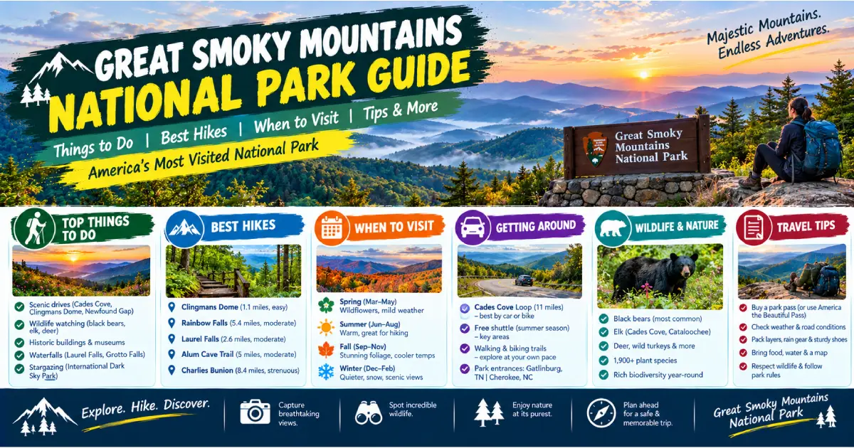
Great Smoky Mountains National Park is the most visited national park in the United States — not by a modest margin but by an extraordinary one: 13.3 million visitors in 2024, nearly three times the visitation of the Grand Canyon and more than twice that of Zion. The park straddles the Tennessee–North Carolina border in the southern Appalachian Mountains, covering 522 square miles of ancient ridgeline forest, wild rivers, and mountain meadows known as “balds.” It is the only national park in the eastern United States that charges no entry fee (a condition of the original land donation, still honored), making it the most accessible major national park in the country for families and budget travelers on the densely populated eastern seaboard.
What makes the Smokies remarkable as a natural landscape is not dramatic vertical relief — the highest peak, Clingmans Dome at 6,643 feet, is a respectable summit but not a Rocky Mountain-scale elevation. What makes them remarkable is biological richness. The Great Smoky Mountains contain more tree species than all of northern Europe — more than 100 species of native trees, compared to roughly 85 in the entire European continent. They support the most diverse salamander fauna in the world (approximately 30 species, earning the park the informal title “Salamander Capital of the World”). The park protects the largest old-growth temperate hardwood forest in eastern North America — trees that were never logged because the rugged terrain defeated the timber companies that stripped the surrounding mountains in the early 20th century. And the fall color display — the transformation of the 500-million-year-old Appalachian hardwood forest from green to the full spectrum of orange, red, gold, and scarlet — is the finest autumn foliage event accessible by road in the United States.
The human history layered into the park is equally significant. The Cherokee people inhabited these mountains for thousands of years before European contact; the park boundary encompasses lands that are still the subject of Cherokee historical claims, and the Eastern Band of Cherokee Indians maintains the Qualla Boundary reservation immediately adjacent to the park’s southern entrance. The Scots-Irish and German settlers who moved into the Appalachian coves in the 18th and 19th centuries built a distinct mountain culture — documented in the preserved homesteads, grist mills, and churches of the Cades Cove and Cataloochee valleys — whose descendants were displaced when the park was established in 1934. Walking through Cades Cove is as much a cultural history experience as a wildlife viewing one.
| Factor | Details |
|---|---|
| Location | Tennessee / North Carolina border, Southern Appalachians |
| Size | 522 square miles (522,427 acres) |
| Established | June 15, 1934 |
| Elevation Range | 876 feet (Abrams Creek) to 6,643 feet (Clingmans Dome) |
| Main Entrances | Gatlinburg, TN (north/Sugarlands); Cherokee, NC (south/Oconaluftee) |
| Other Entrances | Townsend, TN (Cades Cove); Cosby, TN (northeast); Cataloochee, NC (southeast) |
| Entry Fee | Free (no entry fee — the only major national park with no charge) |
| Annual Visitors | ~13.3 million |
| Best Season | April–May (wildflowers), June–August (summer), October (fall color) |
| Website | nps.gov/grsm |
The most common approach for Tennessee-side visitors: I-40 east to Sevierville exit (Exit 407), then US-441 south through Pigeon Forge and Gatlinburg to the Sugarlands Visitor Center. Allow 1–1.5 hours from Knoxville depending on traffic through the Gatlinburg strip (US-441 through Gatlinburg is a single-lane commercial corridor that backs up significantly in peak season — a 30-minute delay in Gatlinburg is common on summer and fall weekends).
I-40 west to Exit 27, then US-19 west through Maggie Valley to Cherokee, then US-441 north into the park. Allow 1.5 hours.
I-85 south to I-26 west to I-40 west to the Asheville approach above.
I-75 north to I-575/US-515 north to Blue Ridge, GA, then US-76/US-64 west to Cherokee, NC, or continue north on I-85 to I-26/I-40 via Asheville.
I-40 east through Cookeville to Knoxville, then follow Knoxville approach above.
McGhee Tyson Airport (TYS), Knoxville: 50 miles from the park’s Tennessee entrance. Nonstop service from Atlanta (ATL), Charlotte (CLT), Chicago O’Hare (ORD), Dallas/Fort Worth (DFW), Denver (DEN), New York LaGuardia (LGA), Philadelphia (PHL), Washington Dulles (IAD), and others. Best airport for park access.
Asheville Regional Airport (AVL): 60 miles from the park’s North Carolina entrance. Nonstop service from major eastern hubs; smaller flight selection than TYS.
Charlotte Douglas International (CLT): 175 miles; the major hub for US Airways/American Airlines connecting flights from the Southeast and internationally.
A car is essential for Great Smoky Mountains. Unlike Zion or Rocky Mountain, the park has no shuttle system within Zion Canyon or Bear Lake Road style — visitors drive between destinations, and the park’s geography (spread across two states, with a mountain ridge running down the middle) means that moving between the Tennessee and North Carolina sides requires planning.
Newfound Gap Road (US-441): The spine of the park — the only road crossing the full width from the Sugarlands Visitor Center (TN) to the Oconaluftee Visitor Center (NC), 30 miles over the Appalachian crest at Newfound Gap (5,046 feet). Open year-round; closures possible in ice and snow.
Cades Cove Loop Road: One-way 11-mile loop through the historic cove. Closed to vehicles on Wednesday and Saturday mornings until 10 AM (bicycle and pedestrian only); otherwise open to motor vehicles throughout the day.
Parking Reservations (2026): The park introduced parking reservations for the most congested trailheads during peak season (mid-May through October). Affected trailheads typically include Alum Cave, Laurel Falls, and Clingmans Dome Road. Check nps.gov/grsm for the 2026 specific reservation requirements; reserve at recreation.gov. Reservations typically open 3 days in advance.
Location: Townsend entrance (west Tennessee side), 25 miles from Sugarlands Visitor Center Hours: Open daily sunrise–sunset; vehicle loop closed to vehicles Wednesday and Saturday mornings until 10 AM Cost: Free
Cades Cove is the single most visited destination in the most visited national park in the United States — approximately 2 million of the park’s 13.3 million annual visitors come specifically to Cades Cove. The cove is an 11-square-mile mountain valley completely enclosed by ridgelines, inhabited by European settlers from the 1820s onward and abandoned when the park was created in the 1930s. The National Park Service preserved the valley’s open meadows (rather than allowing forest succession) and its historic structures: three churches (the Methodist, Primitive Baptist, and Missionary Baptist churches), two grist mills (Cable Mill and Mingus Mill), multiple log homesteads, and a complete working farm (the Henry Whitehead place).
The 11-mile one-way loop road through the cove is the finest combination of wildlife viewing and historical landscape in the eastern national park system. White-tailed deer are visible in the meadows in very large numbers (particularly at dawn and dusk); the park’s black bear population (approximately 1,500 animals, the highest density of black bears in the eastern United States) is most reliably viewed in Cades Cove, particularly in the berry season (late summer) and early fall. Coyotes, wild turkey, and groundhog are also regularly seen.
Practical: The loop road can take 2–4 hours on a congested weekend (summer and fall); allow a full half-day. Arrive at opening (sunrise) for empty roads, the best light, and the highest wildlife activity. The Wednesday and Saturday morning bicycle-only closure (until 10 AM) is the finest way to experience the cove — rent bikes from the Cades Cove Campground store ($10/hour).
Location: Clingmans Dome Road, 7 miles off Newfound Gap Road (US-441) at the NC/TN border Hours: Road open May 1 – November 30; observation tower open year-round (accessible by foot from the parking area in winter) Cost: Free; parking reservation may be required at peak times in 2026 (check nps.gov/grsm)
Clingmans Dome (6,643 feet) is the highest point in Great Smoky Mountains National Park, the highest point in Tennessee, and the third-highest peak east of the Mississippi. The summit is accessible via a 0.5-mile paved trail (steep — 332-foot elevation gain in half a mile) to a concrete observation ramp with 360-degree views above the treeline. The view from Clingmans Dome on a clear day — across the Appalachian ridgelines in all directions, with no town, road, or structure visible except the tower itself — is the finest panoramic view in the eastern United States.
The spruce-fir forest: The summit area of Clingmans Dome is covered in Fraser fir and red spruce — a boreal forest type that, at this latitude, exists only above 5,500 feet and represents a relic of the cool climate that extended throughout the Appalachians during the last Ice Age. The Fraser fir is severely threatened by the balsam woolly adelgid (an invasive insect introduced from Europe in the 1950s); a large proportion of the trees in the summit area are dead standing snags, and the NPS conducts active adelgid management. The ghost forest of dead fir snags above the living understory is both ecologically tragic and visually striking.
Clear day strategy: Clingmans Dome is frequently in cloud (the “smoke” of the Smokies is primarily organic haze from the forest, combined with cloud formation at ridge level); the summit is in clouds approximately 200 days per year. Check the visibility forecast (weather.gov/mrx for Knoxville area) and go on a clear post-frontal day (after a cold front passes, visibility increases dramatically for 24–48 hours).
The finest trail in the Tennessee side of the park — a route through old-growth hemlock forest (much decimated by the hemlock woolly adelgid but still significant), Arch Rock (a natural stone arch eroded through the Anakeesta slate formation that the trail passes through), the Alum Cave Bluffs (an enormous overhanging bluff face created by differential erosion — the alum mineral gives the distinctive white-orange coloration), and — for those continuing to the summit — Mount LeConte (6,593 feet), the third-highest peak in the park and one of the most rewarding summit destinations in the Smokies.
LeConte Lodge: The summit of Mount LeConte is the only location in the national park system (aside from a handful of western sites) with a backcountry lodge — a cluster of log cabins operating since 1926, accessible only on foot (the shortest approach is 5.5 miles), serving dinner and breakfast, and housing up to 50 guests per night. Reservations open in October for the following year and sell out within hours. leconte-lodge.com. The experience — falling asleep on a 6,593-foot summit after a communal dinner in a log cabin with no phone signal — is one of the most distinctive in the American national park system.
Laurel Falls — a 75-foot two-tiered waterfall on Laurel Branch — is the most visited waterfall in Great Smoky Mountains National Park. The paved trail to the falls is accessible to most ability levels and passes through mature pine-oak forest. Go very early (before 8 AM) or mid-week; the Laurel Falls parking area is one of the most congested in the park at peak times.
The Appalachian Trail crosses 71 miles of Great Smoky Mountains National Park along the Tennessee–North Carolina border ridge — the longest single section of the AT within any national park. The most accessible section for day hikers: Newfound Gap to Charlies Bunion (8 miles round-trip, 1,600 feet elevation gain) — a ridge walk from the Newfound Gap parking area (5,046 feet) east to Charlies Bunion (5,375 feet), a rocky promontory with 270-degree views across the park’s interior and the exposed Anakeesta slate rock formation. One of the finest day hikes in the entire Appalachian Trail corridor.
Clingmans Dome to Double Spring Gap shelter (3 miles one-way): The highest section of the AT east of the Mississippi — a ridge walk through the spruce-fir forest between Clingmans Dome and the Double Spring Gap shelter, almost entirely above 6,000 feet. Outstanding for the boreal forest experience.
Location: North Carolina side, accessed via I-40 west from Asheville to Exit 20, then unpaved road (11 miles, requires slow driving) Hours: Open daily Cost: Free
Cataloochee is the finest wildlife-watching destination in Great Smoky Mountains National Park — a broad valley on the North Carolina side containing the ruins of a 19th-century mountain farming community (school, church, two barns, multiple homesteads) and the park’s elk herd, reintroduced to the Smokies in 2001 after being extirpated from the region in the 19th century. The current herd numbers approximately 200 animals; the bulls bugle during the fall rut (September–October) in the open meadows around the Palmer and Beech Grove farm sites in a spectacle that rivals the Rocky Mountain rut for atmosphere, if not for scale.
Practical: The access road to Cataloochee is unpaved and narrow — not difficult for standard passenger cars but requiring slow, cautious driving. The valley floor is open meadow; arrive at dawn (30 minutes before sunrise) for the highest elk activity and empty meadows. The herd is most concentrated near the Palmer Farm site and Beech Grove School areas (both marked on the park map).
When: Late May to early June (typically 2-week window); 2026 estimated peak: late May Location: Elkmont Campground area, Tennessee side Access: Lottery-required shuttle from Sugarlands Visitor Center; no private vehicles to Elkmont during the event Cost: Free; shuttle $1/person
The synchronous fireflies (Photinus carolinus) of Great Smoky Mountains National Park are one of the most remarkable natural phenomena in North America — a species of firefly (one of approximately 19 firefly species in the park) whose males flash in synchronized pulses, creating a coordinated light display across the darkened forest floor that has no analog in temperate North America. The display occurs for approximately 2 weeks each year when the males are seeking mates; the peak 2-week window varies by 1–3 weeks year to year depending on temperature.
The NPS manages access to the Elkmont synchronous firefly viewing area through a lottery (open in April at recreation.gov); lottery tickets ($1/person) sell out within minutes of opening. Apply immediately when the lottery opens. This is one of the most difficult NPS tickets to obtain in the country — tens of thousands of applications for approximately 800 nightly permits.
The Smokies have more than 100 named waterfalls, fed by one of the highest annual precipitation rates of any location in the eastern United States (85 inches per year at the higher elevations). The finest waterfall hikes beyond Laurel Falls:
Location: Accessed from Historic Nature Trail Road in Gatlinburg; one-way loop, 5.5 miles Hours: Open April–November; closed in winter Cost: Free; standard passenger vehicles only (no RVs or trailers)
Roaring Fork is the finest short scenic drive in the Tennessee side of the park — a one-way road through old-growth hemlock and hardwood forest, past multiple historic homesteads (the Alfred Reagan Place, the Ephraim Bales Place), and three waterfall trailheads (Grotto Falls, Place of a Thousand Drips, Rainbow Falls). The motor nature trail provides a condensed version of the full Smokies experience in approximately 1.5–2 hours with short walks at each stop.
The Chimney Tops — twin rocky promontories rising above the treeline at 4,755 feet — were heavily damaged in the November 2016 wildfire (the Chimney Tops 2 Fire, which killed 14 people in Gatlinburg and destroyed 2,400 structures). The NPS has partially reopened the trail to the Chimney Tops viewpoint; check nps.gov/grsm for current access status for 2026.
Great Smoky Mountains National Park offers the finest accessible autumn foliage display in the United States — the diversity of Appalachian hardwood species (red maple, sugar maple, yellow birch, American beech, sweet gum, black gum, sourwood, sassafras, and dozens more) produces a wider spectrum of fall colors than any other forest type in North America, and the park’s 5,000-foot elevation range means that color progresses downslope over 4–6 weeks from late September through late October.
Fall color timeline:
2026 peak color projection: Based on average years, expect mid-elevation peak color around October 12–22, 2026. For real-time color reports: smokymountains.com/fall-foliage-map and the park’s own nps.gov/grsm updates.
Traffic: Fall color weekends (particularly the two Columbus Day / Indigenous Peoples Day weekends in early and mid-October) are the most congested times in the park. Cades Cove Loop Road can back up for hours; arrive before 7 AM or come mid-week. The Newfound Gap Road and Clingmans Dome Road become parking-lot slow on peak color Sundays.
Great Smoky Mountains National Park hosts the finest wildflower display east of the Mississippi — the extraordinary biological richness of the old-growth forest floor produces over 1,500 flowering plant species, and the spring bloom begins as early as late February at the lowest elevations and continues through June at the high-elevation balds.
Wildflower highlights:
Wildflower Pilgrimage: The annual Spring Wildflower Pilgrimage (late April, Gatlinburg; springwildflowerpilgrimage.org) runs 150+ guided walks and programs over 5 days. The finest single event in the park’s interpretive calendar.
Black bears: The park’s approximately 1,500 black bears represent the highest density of black bears in the eastern United States — roughly 2 bears per square mile. Bears are visible throughout the park but most reliably in Cades Cove, the Roaring Fork area, and along Newfound Gap Road, particularly in the berry season (late July–September) and in spring. Mandatory bear safety: All food and scented items must be stored in a bear box or bear canister in the backcountry; never feed bears (federal offense, $5,000 fine); maintain 50-yard distance. If a bear approaches: do not run; face it, make noise, make yourself large. Bear spray is legal and recommended for backcountry travel.
Elk: Approximately 200 animals, primarily in the Cataloochee Valley (NC side) and the Oconaluftee Valley near the Cherokee entrance (TN/NC border area). The reintroduction (beginning in 2001 from Elk Island National Park in Canada) is considered one of the most successful large mammal reintroductions in eastern National Park history.
White-tailed deer: Abundant throughout the park; Cades Cove meadows support very high density. Visible at dawn and dusk year-round.
Wild turkey: Large flocks throughout the park; most visible in Cades Cove and the lower Oconaluftee Valley.
Salamanders: The park’s 30 species of salamanders represent the world’s greatest concentration of salamander diversity. Most visible in spring and fall near streams and under logs at the lower elevations; the Hellbender (the largest salamander in North America, up to 29 inches) inhabits the park’s larger clear streams.
Gatlinburg is the primary gateway town — a dense commercial strip (the “Parkway,” US-441) of cabin rentals, motels, restaurants, and attractions (Ripley’s Aquarium of the Smokies is the largest paid attraction). Accommodation is abundant and ranges widely in quality.
The Lodge at Buckberry Creek ($$$, 961 Campbell Lead Rd): The finest boutique hotel in Gatlinburg — a timber-frame lodge with mountain views, a full spa, and a dining room using Appalachian ingredients. $250–450/night.
The Park Vista — A DoubleTree by Hilton ($$$, 705 Cherokee Orchard Rd): The finest chain hotel in Gatlinburg — full service, park-adjacent location with forest views, pool. $170–300/night.
Zoder’s Inn ($$, 402 Parkway): Gatlinburg institution since 1948 — well-maintained mid-range motel on the main strip. $90–160/night.
Cabin rentals: The most popular accommodation style in the Gatlinburg/Pigeon Forge area — thousands of privately owned mountain cabins and chalets available via Airbnb, VRBO, and local rental companies (Gatlinburg Cabins Online, Smoky Mountain Rentals). 1-bedroom cabins $100–200/night; larger group cabins $200–600+/night. Cabin rentals with hot tubs and mountain views are the defining Smokies accommodation experience.
Cherokee (Eastern Band of Cherokee Indians reservation, Qualla Boundary) is the quieter, less commercial gateway on the North Carolina side — a genuine Native American community with its own museum, casino, and cultural sites.
Harrah’s Cherokee Casino Resort ($$$, 777 Casino Dr): The finest full-service hotel on the NC side — 21-story tower, multiple restaurants, entertainment, casino. $150–280/night.
Holiday Inn Express Cherokee ($$, 285 Painttown Rd): Clean, reliable, well-positioned for Oconaluftee entrance access. $100–180/night.
| Campground | Location | Sites | Fee | Season | Notes |
|---|---|---|---|---|---|
| Cades Cove | Townsend, TN side | 159 | $25/night | Year-round | Most popular; wildlife access; camp store |
| Elkmont | Gatlinburg, TN side | 220 | $25/night | Year-round | Largest campground; synchronous firefly area; Little River |
| Smokemont | Cherokee, NC side | 142 | $25/night | Year-round | Oconaluftee River; good NC access |
| Abrams Creek | Extreme west TN | 16 | $17/night | May–October | Remote; hike-in feel; small; first-come, first-served |
| Cosby | Northeast TN | 157 | $17.50/night | April–October | Quietest large campground; excellent for hikers |
| Cataloochee | North Carolina | 27 | $25/night | March–October | Near elk herd; reservation essential; very popular |
| Balsam Mountain | North Carolina | 46 | $17.50/night | May–October | Highest campground (5,310 ft); cool even in summer; remote |
All campgrounds reservable at recreation.gov (Cataloochee and Elkmont during synchronous firefly season book out immediately; reserve as far in advance as possible).
LeConte Lodge: Backcountry log cabin lodging at the summit of Mount LeConte (6,593 feet) — dinner and breakfast included, no electricity, accessible only on foot. $155–175/person/night. Reservations open each October for the following year and sell out within hours. leconte-lodge.com.
The Peddler Steakhouse ($$$, 820 River Rd): Gatlinburg institution since 1976 — fresh-cut steaks grilled over a charcoal fire, suspended over a tumbling mountain creek, salad bar with 50+ items. The most atmospheric restaurant in Gatlinburg; reserve ahead.
Pancake Pantry ($$, 628 Parkway): The most famous breakfast in the Smokies — a Gatlinburg institution since 1960, serving 24 varieties of pancakes. Expect a 30–60 minute wait on weekend mornings; arrive at 7 AM.
The Greenbrier Restaurant ($$$, 370 Newman Rd): Fine dining in a converted Victorian hunting lodge — the finest Appalachian cuisine in the region. Game, local trout, ramps in season.
Local Goat ($$, 146 Parkway): Farm-to-table casual, burgers and small plates, the best bar in Gatlinburg.
Reagan’s Rubs ($$, 631 Parkway): The finest BBQ on the Tennessee side — dry-rub ribs, pulled pork, Tennessee whiskey sauces.
Granny’s Kitchen ($$, US-441 business route): Country ham biscuits, stack cakes, Cherokee-Appalachian breakfast staples; a genuine local institution.
Harrah’s Cherokee restaurants: Peter’s Sunset Grille (fine dining, hotel reservation required) and Selu Garden Café (casual, daily, accessible to non-hotel guests).
Pigeon Forge is the entertainment hub of the Smokies corridor — Dollywood (the finest regional theme park in the South, 50+ rides, exceptional live music programming, Dolly Parton’s personal investment), outlet malls, and the most concentrated collection of family entertainment in Appalachia. Dollywood tickets $99–129/adult (dollywoood.com; book in advance for peak season). The Dollywood Harvest Festival (late September–November) and Smoky Mountain Christmas (November–January) are the finest seasonal events.
A living history museum of 18th-century Cherokee life, operated by the Eastern Band of Cherokee Indians — fully staffed re-creation of a 1750s Cherokee village with demonstration of traditional crafts (pottery, beadwork, basket weaving, blowgun), Cherokee language instruction, and cultural interpretation. $23/adult. The adjacent Museum of the Cherokee People (free with village ticket or $10 separately) is the finest Cherokee cultural institution in the United States; reopened in 2021 after a $21 million renovation with a new permanent collection telling Cherokee history from the Cherokee perspective.
The Blue Ridge Parkway — the 469-mile scenic highway running along the Appalachian crest from Shenandoah National Park (Virginia) to the Smokies (connecting to US-441 at Cherokee, NC) — provides one of the finest scenic drives in the United States. The Waterrock Knob overlook (milepost 451.2, 6,292 feet, 30 miles from Cherokee) offers the finest panoramic view on the southern Parkway, with 360-degree views of the Smoky Mountains and the Black Mountains to the northeast. The Balsam Mountain Inn (near milepost 443) is a National Historic Landmark Victorian resort in the highest incorporated municipality in the eastern US.
The Nantahala River gorge (65 miles from the Oconaluftee entrance) is the most-rafted whitewater destination in the eastern United States — Class II–III continuous rapids in a deep gorge ending at the Nantahala Falls drop. Full-day guided rafting trips from multiple outfitters based at the gorge: NOC (Nantahala Outdoor Center, noc.com; half-day $35–50/person). The Nantahala Outdoor Center at the gorge is the finest paddling-focused outdoor recreation facility in the South.
| Budget Level | Daily Cost Per Person | What’s Included |
|---|---|---|
| Budget (camping) | $30–60/day | Campground ($17.50–25/night); groceries from Gatlinburg/Cherokee markets; free park admission; free trails |
| Mid-Range | $120–200/day | Gatlinburg motel; restaurant meals; one paid attraction (Clingmans Dome parking, if any; museum in Cherokee); cabin rental |
| Luxury | $280–500+/day | Buckberry Creek or LeConte Lodge; fine dining; Dollywood; guided fly fishing on park streams |
Note: Great Smoky Mountains is the only major US national park with no entry fee — a significant cost advantage over western parks ($35/vehicle at Zion, Rocky Mountain, etc.).
6:30 AM: Cades Cove — arrive at sunrise, wildlife viewing in the meadows (deer, bear possible), Cable Mill historic tour. 10 AM: Drive Newfound Gap Road to Clingmans Dome (if road open); 0.5-mile summit walk. Views across the Smokies. 12 PM: Picnic at Newfound Gap. 1:30 PM: Alum Cave Trail to Alum Cave Bluffs (4.4 miles round-trip, 2.5 hours). 4 PM: Return to Gatlinburg via Newfound Gap Road; dinner at The Peddler Steakhouse.
Day 1 (Tennessee side): Cades Cove (morning, arrive 7 AM) + Abrams Falls hike (afternoon, 5 miles, 2.5 hours) + Roaring Fork Motor Nature Trail (sunset, Grotto Falls stop).
Day 2 (NC side and summit): Drive Newfound Gap Road to Clingmans Dome (morning, clear skies) + Charlies Bunion via the AT from Newfound Gap (8 miles round-trip, afternoon) + Cataloochee Valley (drive at dawn if 2-night stay, or drive in late afternoon for elk).
Day 1: Cades Cove + Abrams Falls. Day 2: Clingmans Dome + Alum Cave to LeConte (day hike only, 11 miles round-trip — or stay at LeConte Lodge if reservation secured). Day 3: Cataloochee Valley (dawn elk viewing) + Museum of the Cherokee People + Blue Ridge Parkway to Waterrock Knob.
Great Smoky Mountains is the only major national park in the United States with no vehicle entry fee — a condition of the original Rockefeller-funded land donation in the 1930s that has been honored continuously. There is no fee to enter, no timed-entry ticket required for the park as a whole (though parking reservations are required at specific trailheads in 2026 peak season — see above), and no charge for the Newfound Gap Road crossing.
The Smokies have the highest annual precipitation of any location in the eastern United States outside the Olympic Peninsula — 55 inches annually at valley elevations, 85 inches at high elevations. Rain is possible in any month and requires no season-specific planning: carry a rain jacket. Summer afternoon thunderstorms are common above the treeline (Clingmans Dome, the AT ridge); descend before noon if thunderstorms are forecast. Snow at high elevations occurs from November through April; Newfound Gap Road and Clingmans Dome Road close during winter storms and reopen when plowed.
The park’s extraordinary biological richness — old-growth forest floor, salamander habitat, wildflower communities — is under direct pressure from 13 million annual visitors. Staying on trails, never picking wildflowers (it is illegal in the park, and the wildflower populations at popular trails have declined measurably), carrying out all waste, and keeping noise levels low in wildlife areas are all practices with direct, measurable impact in this park.
Posted By : Vinay
Latest Article
2nd Floor, 39, Above Kirti Club, DLF Industrial Area, Kirti Nagar, New Delhi, Delhi 110015



Travel Tourister is a leading Travel portal where we introduce travellers to trusted travel agents to make their journey hasselfree, memorable And happy. Travel Tourister is a platform where travellers get Tour packages ,Hotel packages deals through trusted travel companies And hoteliers who are working with us across the world. We always try to find new and more travel agents and hoteliers from every nook and corners across the world so that you could compare the deals with different travel agents and hoteliers and book your tour or hotel with the one you have chosen according to your taste and budget.
Copyright © Travel Tourister, India. All Rights Reserved

 Call
 Enquiry