Published on : 02 Nov 2026
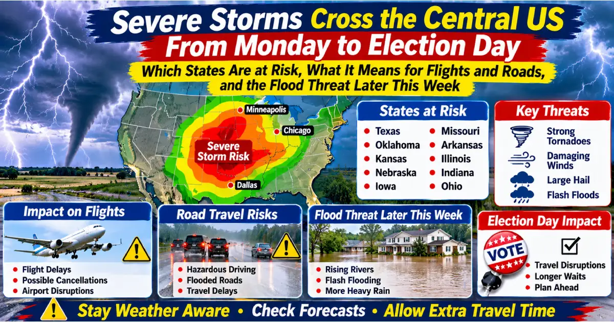
TRENDING: A COLD FRONT AND DRYLINE ARE EXPECTED TO TRIGGER SEVERE STORMS MONDAY AFTERNOON AND EVENING OVER KANSAS, OKLAHOMA AND NORTH TEXAS, WITH LARGE HAIL, DAMAGING WINDS AND A FEW TORNADOES POSSIBLE. THE THREAT MOVES INTO THE DEEP SOUTH ON ELECTION DAY, TUESDAY NOV 3, AND HEAVY RAIN SPREADS ACROSS THE MIDWEST ON WEDNESDAY. NO WIDESPREAD AIRPORT CLOSURES HAVE BEEN REPORTED. HERE IS WHAT TO CHECK BEFORE YOU FLY OR DRIVE.
Published: November 2, 2026 | Source: Fox Weather (via AOL), AccuWeather, National Weather Service Tulsa (via Country Herald), Storm Prediction Center (via Rus Tourism News)
This is a travel-risk guide. Severe-weather outlooks describe area-wide risk, not the chance that any one traveller will be affected. This is the second stage of the storm in our Four Corners flood article.
| Day | What is expected |
|---|---|
| Sunday night (Southwest) | A Level 3 of 4 flash-flood risk covers more than 65,000 sq miles, including nearly all of central and northern Arizona and over 4 million people (Fox Weather) |
| Monday Nov 2: Plains | Severe storms develop in the afternoon and evening over parts of Kansas, Oklahoma and north Texas as a cold front and dryline move through. The Storm Prediction Center has a Level 2 of 5 risk over south-central and eastern Kansas, western and central Oklahoma and north Texas |
| Tuesday Nov 3: Election Day | The front reaches the Deep South, with a threat of damaging winds in Louisiana, Mississippi, Arkansas and Alabama. AccuWeather says the severe risk may also include Missouri and Tennessee on Tuesday and Wednesday |
| Wednesday Nov 4 | Wind gusts of 40 to 50 mph from eastern Kansas and Nebraska through Iowa, Minnesota and Wisconsin. Heavy rain of 1 to 2 inches or more from Texas to Minnesota. A Level 1 of 4 excessive-rainfall risk covers a dozen states, with localised flooding possible in Omaha, Des Moines and Minneapolis |
| Thursday to Saturday | The storm reaches the Great Lakes and Mid-Atlantic, with rain along the I-95 corridor around Thursday or Friday. Totals above 1 inch are possible in the Northeast, with localised amounts near 2 inches from central Pennsylvania and Maryland through the New York City area |
Fox Weather said earlier (Oct 30) that about 40 million people were under a Level 1 of 4 flash-flood threat from Texas to Wisconsin on Monday. Its Nov 2 update places the Level 1 of 4 on Wednesday. Check the Weather Prediction Center for the current day-by-day map.
| Item | Detail |
|---|---|
| Main hazard | Damaging straight-line winds. Large hail and a few tornadoes are also possible |
| How it unfolds | Storms form on the dryline, then merge into a line that moves east across Oklahoma, Kansas and north Texas Monday evening and overnight, weakening gradually |
| Tulsa and northeast Oklahoma | The NWS Tulsa office says storms could start as early as 1pm, with the most likely window 7pm to midnight, possibly to 2am Tuesday. Damaging gusts could reach about 70 mph and hail up to quarter size |
| Muskogee and eastern Oklahoma | About 11pm Monday to 4am Tuesday |
| Fayetteville and Fort Smith, Arkansas | About 2am to 6am Tuesday, possibly to 8am |
| Roads named | I-44, I-40 and I-49 |
AccuWeather’s forecast, updated Nov 1:
If you are travelling to vote, or flying in or out of the storm area on Tuesday, allow extra time and check your route and flight status.
✓ Avoid driving through the evening storm window on I-44, I-40 and I-49 if you can ✓ Turn around, don’t drown. Never cross flooded roads ✓ Pull off safely if hail or very strong winds hit. High-sided vehicles are most exposed ✓ Keep your phone charged and enable emergency alerts. Power outages are possible ✓ Check your state DOT’s road map before long drives ✓ Plan for overnight storms in eastern Oklahoma and northwest Arkansas (about 11pm to 8am)
✓ Check your flight status in your airline’s app before you leave ✓ Watch your connection hub. A storm at DFW or another hub can delay a flight that never goes near it ✓ Fly earlier in the day if you can. Thunderstorms usually peak in the evening ✓ Ask your airline about waivers and free rebooking if one is issued ✓ Keep receipts for meals and hotels
| Situation | What generally applies |
|---|---|
| Cancelled flight | You are entitled to a refund if you decline the rebooked flight (DOT rule) |
| Weather delay or cancellation | No fixed cash compensation. Meals and hotels depend on the airline’s policy, and are less likely for weather |
| Rebooking | Ask for the next flight, and for a waiver if one is issued |
| Insurance | Check travel insurance and credit-card benefits for weather cover. Keep notices and receipts |
The storm’s first stage is still affecting the Southwest (Fox Weather, Nov 2):
Check COtrip.org, AZ511.gov and NMroads.com before you drive.
Posted By : Vinay
This article is provided for general informational purposes only and is based on information available at the time of publication. Travel advisories, airline schedules, airport operations, visa requirements, government regulations, and other travel-related information are subject to change without prior notice. While Travel Tourister makes reasonable efforts to verify information using official announcements, government publications, airline and airport communications, and other reliable sources, we cannot guarantee that all information remains complete, accurate, or up to date at all times. Readers should independently verify any information that may affect their travel plans with the relevant airline, airport authority, government agency, embassy, or other official source before making travel, financial, or other decisions. Travel Tourister shall not be liable for any direct or indirect loss, inconvenience, or damages arising from the use of or reliance on the information contained in this article. Nothing in this publication constitutes legal, immigration, financial, or professional travel advice. If you believe any information in this article is inaccurate or outdated, please contact our editorial team. We review all credible correction requests promptly and update our content whenever appropriate.
Lastest News
2nd Floor, 39, Above Kirti Club, DLF Industrial Area, Kirti Nagar, New Delhi, Delhi 110015



Travel Tourister is a leading Travel portal where we introduce travellers to trusted travel agents to make their journey hasselfree, memorable And happy. Travel Tourister is a platform where travellers get Tour packages ,Hotel packages deals through trusted travel companies And hoteliers who are working with us across the world. We always try to find new and more travel agents and hoteliers from every nook and corners across the world so that you could compare the deals with different travel agents and hoteliers and book your tour or hotel with the one you have chosen according to your taste and budget.
Copyright © Travel Tourister, India. All Rights Reserved

 Call
 Enquiry