Published on : 31 Jan 2026
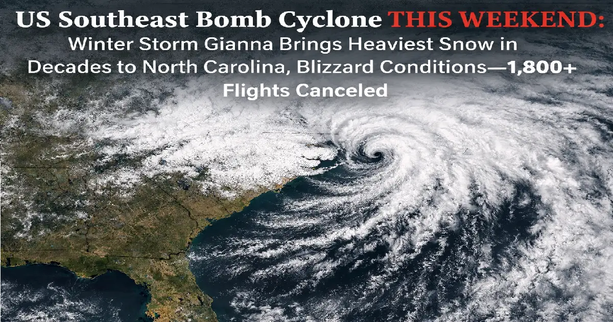
Breaking: A bomb cyclone is slamming the US Southeast THIS WEEKEND (January 31-February 2, 2026) with the heaviest snow North Carolina has seen in 6-8 years. Raleigh could get 5-8 inches, Columbia, SC faces its biggest storm since 2010, and coastal areas brace for BLIZZARD conditions with 70mph hurricane-force winds. Airlines already canceled 1,800+ flights through Saturday, with American cutting 16% of its schedule. States of emergency declared across NC, SC, Georgia, Virginia. Here’s everything you need to know NOW.
Published: January 31, 2026 Storm Timing: Friday Night (Jan 31) → Sunday Afternoon (Feb 2) Named Storm: Winter Storm Gianna People Affected: 28+ million under winter storm watches/warnings Flights Canceled: 1,800+ through Saturday (rising rapidly) Bomb Cyclone: Pressure drops 35-40 millibars in 24 hours Historic: Heaviest snow in decades for Raleigh, Columbia, Wilmington
A powerful nor’easter is forming off the Carolina coast THIS EVENING and will explode into a bomb cyclone overnight Friday-Saturday. The storm will dump 8-12 inches of snow across eastern North Carolina and the Outer Banks, with blizzard conditions (70mph winds + heavy snow + near-zero visibility) slamming coastal areas.
This is a RARE event—bomb cyclones typically hit the northern US (New England), not the Southeast. The last comparable storm hit North Carolina in December 2018.
Key Alerts:
⚠️ Winter Storm Warnings: ALL of North Carolina, most of South Carolina, portions of Virginia, Georgia ⚠️ Blizzard Warnings: Eastern NC coast, Outer Banks, southeastern Virginia ⚠️ Coastal Flood Warnings: NC/VA/MD coast (moderate to major flooding at high tide) ⚠️ States of Emergency: NC, SC, GA, VA, TN, MO, NY, TX declared ⚠️ Travel Waivers: American, Delta, United, Southwest, JetBlue issued
Eastern North Carolina Coast:
This would be the heaviest coastal snow in decades for these areas.
North Carolina Piedmont:
Southeastern Virginia:
This is historic for Raleigh—any total over 7 inches would be the biggest snowfall since December 2018.
Charlotte Metro:
South Carolina:
Even 3-5 inches is MAJOR for Charlotte, where infrastructure isn’t built for snow.
Northern Georgia:
Western North Carolina:
Even 1-2 inches shuts down Atlanta—the city doesn’t have adequate snow removal equipment.
A blizzard isn’t just heavy snow—it requires: ✅ Sustained winds 35+ mph for 3+ hours ✅ Falling/blowing snow reducing visibility to 1/4 mile or less ✅ Life-threatening conditions
Blizzard Warning Areas (Now in Effect):
Eastern North Carolina Coast:
Southeastern Virginia:
Possible Blizzard (if storm tracks right):
What Blizzard Means:
DO NOT TRAVEL in blizzard warning areas Saturday-Sunday. Emergency crews cannot reach you.
Airlines started canceling flights Thursday and Friday ahead of the storm. Expect thousands more cancellations Saturday-Sunday.
Through Saturday: 1,800+ flights canceled American Airlines: 16% of Saturday schedule cut Delta: Major schedule adjustments Atlanta hub Airports hit hardest: CLT, RDU, ATL, ORF, PHL
This is on top of 20,000+ cancellations from Winter Storm Fern last weekend—airlines are still recovering.
Charlotte Douglas (CLT) – American Airlines Hub:
Raleigh-Durham (RDU):
Atlanta Hartsfield-Jackson (ATL) – Delta Hub:
Norfolk International (ORF):
Wilmington (ILM):
Other Affected Airports:
Major Hubs with Ripple Effects:
American Airlines already lost $200 million to Winter Storm Fern last week. This storm adds more financial pain.
Every major US airline issued travel waivers allowing free rebooking.
Covered Airports (34 total): Including ATL, CLT, RDU, DFW, PHL, TN airports Original Travel Dates: January 31 – February 2, 2026 Rebook Window: Must rebook by February 3, 2026 New Travel Dates: Complete travel within 1 year of original ticket Fee Waiver: No change fees or fare differences (same cabin) Check Status: aa.com/travelalerts
American’s Move: Adding 3,200+ extra seats to/from Dallas-Fort Worth to help displaced passengers.
Covered Regions:
Original Travel Dates: Through Monday, February 3, 2026 Rebook Window: Rebook by February 3 New Travel Dates: Within policy limits Fee Waiver: No change fees or fare differences Atlanta Warning: “Significant schedule adjustments through Sunday due to ice accumulation” Check Status: delta.com or Delta app
Covered Airports (35 total): Including EWR, IAD, CLT, RDU, ATL Original Travel Dates: January 31 – February 2, 2026 Rebook Window: Flexible New Travel Dates: Check United policy Fee Waiver: No change fees Proactive Cancellations: United canceling Newark/Dulles flights to prevent aircraft strandings Check Status: united.com/travelalerts
Covered Airports (46 total): Including DAL, BWI, BNA, MDW, plus affected Southeast cities Original Travel Dates: Through Monday, February 3, 2026 Rebook Window: Within 14 days of original departure New Travel Dates: Any date within 14-day window Fee Waiver: No fare difference if same class of service Check Status: southwest.com/travelalerts
Waiver 1 – Northeast (13 airports):
Waiver 2 – Southeast/Mid-Atlantic:
Check Status: jetblue.com/travelalerts
Covered: BOS, CLE, RDU, DCA, IAD Original Travel Dates: Through February 3, 2026 Toronto Recovery: YYZ waiver through February 3 (still recovering from Toronto snowstorm) Check Status: aircanada.com
Step 1: Check if You’re Covered
Step 2: Decide Your Strategy
Option A – Rebook Now:
Option B – Wait and See:
Option C – Take a Refund:
Step 3: Rebook Online (Easiest)
Step 4: Call If Needed
Step 5: Monitor Flight Status
Pro Tips: ✅ Rebook early – best alternative flights go fast ✅ Consider different airports – fly into nearby city, rent car ✅ Book farther out – Monday/Tuesday likely clearer than Sunday ✅ Avoid connections – nonstops less likely to cascade delays ✅ Screenshot waiver terms – proof if airline disputes later
DO NOT go to the airport if your flight is canceled. Rebook online or by phone.
Snow doesn’t just shut down airports—it paralyzes highways across the Southeast, where infrastructure isn’t built for winter weather.
Interstate 95 (I-95) – East Coast Main Artery:
Interstate 40 (I-40) – East-West Across NC:
Interstate 85 (I-85) – Southeast Corridor:
Interstate 77 (I-77) – North-South Through Charlotte:
Interstate 20 (I-20) – Southern Corridor:
Interstate 81 (I-81) – Appalachian Route:
Interstate 75 (I-75) – Through Atlanta:
Interstate 64 (I-64) – Through Norfolk:
1. No Infrastructure:
2. Drivers Inexperienced:
3. Temperatures Right at Freezing:
4. Bridges/Overpasses Ice First:
State DOT Warnings:
If you MUST drive: ✅ Fill gas tank (may be stranded for hours) ✅ Pack emergency kit (blankets, food, water, phone charger) ✅ Tell someone your route and ETA ✅ Drive SLOW (half normal speed minimum) ✅ Avoid cruise control ✅ Keep distance from other vehicles ✅ If you start sliding, DON’T brake hard (steer into slide) ✅ Turn around if conditions worsen
Better option: DON’T DRIVE. Postpone the trip.
You keep hearing “bomb cyclone”—what does it actually mean?
Bomb cyclone = Bombogenesis = Explosive cyclogenesis
A storm becomes a bomb cyclone when its central air pressure drops at least 24 millibars in 24 hours (at 60° latitude). The calculation varies by latitude—closer to the equator requires smaller pressure drops.
This Weekend’s Storm:
Rapid pressure drops = explosive storm intensification:
✅ Winds strengthen dramatically (from 20mph → 70mph in hours) ✅ Snow rates increase (light flurries → 2″/hour heavy bands) ✅ Storm size grows (affects larger geographic area) ✅ Coastal flooding worsens (low pressure = higher storm surge) ✅ Blizzard conditions develop (wind + snow = zero visibility)
What Causes Bombogenesis:
When these ingredients align, the storm “bombs out”—rapidly strengthening into a meteorological beast.
Why This Is Unusual:
This storm is a 5-10 year event for the Southeast.
Famous Bomb Cyclones:
This weekend’s storm joins that list as a Southeast equivalent—rare, powerful, potentially historic.
Is this really “historic”? Here’s how forecasted totals compare to past benchmarks:
Forecast: 5-8 inches
Historic Storms:
Verdict: If Raleigh gets 7+ inches, it would be the biggest snowstorm since December 2018 (8 years ago). That qualifies as “historic” by local standards.
Forecast: 3-5 inches
Historic Storms:
Verdict: 3-5″ would match or exceed the January 2018 storm (most recent significant event). Disruptive but not record-breaking.
Forecast: 4-7 inches
Historic Storms:
Verdict: If Columbia gets 7+ inches, it would be the heaviest snowfall since February 2010 (16 years ago). That’s genuinely historic.
Forecast: 8-12 inches
Historic Storms:
Verdict: 8-12″ would SHATTER Wilmington’s snowfall record by nearly double. This would be a once-in-50-years event for coastal NC.
Forecast: 7-12 inches + blizzard
Historic Storms:
Verdict: 7-12″ is a major storm for Norfolk but not record-breaking. The blizzard conditions (wind + coastal flooding) make it more dangerous than snowfall alone.
Forecast: 1-2 inches
Historic Storms:
Verdict: Even 1-2″ is a BIG DEAL for Atlanta. The city famously shut down for days with just 2.6″ in 2014 (“Snowpocalypse”). Infrastructure can’t handle it.
Snow isn’t the only threat—the bomb cyclone will batter the coast with winds and flooding.
Coastal Areas (Blizzard Zone):
Inland Areas:
Why High Winds Matter: ✅ Blowing snow creates whiteout conditions (zero visibility) ✅ Wind chill makes feels-like temps in single digits/below zero ✅ Power lines snap (tree limbs heavy with snow + wind = outages) ✅ Coastal flooding worsens (wind drives water onshore) ✅ Travel impossible even in 4WD vehicles
Moderate to Major Coastal Flooding Expected:
North Carolina Coast:
Virginia Coast:
Timing: Saturday high tides (worst flooding)
Flood Levels:
Mechanism:
Affected Areas:
Evacuation Orders: Check local emergency management—some coastal areas may order evacuations Saturday.
Heavy wet snow + high winds = widespread power outages.
Why Power Fails:
High-Risk Areas:
Outage Estimates:
Preparation: ✅ Charge all devices NOW ✅ Fill bathtub with water (if power fails, pumps stop) ✅ Stock non-perishable food ✅ Have flashlights, batteries, candles ✅ Backup heat source if electric heat (fireplace, generator) ✅ Generator if you have one (run OUTSIDE only—carbon monoxide kills) ✅ Don’t open fridge/freezer (keeps food cold longer)
Utility company websites:
Report outages immediately—utilities prioritize areas by number of customers affected.
The storm is just the beginning—brutal Arctic air follows Sunday-Tuesday.
Sunday-Tuesday (February 2-4):
High Temperatures (Daytime):
Low Temperatures (Nighttime):
Wind Chill (Feels-Like Temperature):
Florida Impact:
1. Black Ice:
2. Burst Pipes:
3. Hypothermia/Frostbite:
4. Airport De-Icing Delays:
Warming shelters open across NC/SC/GA/VA—check local emergency management websites.
✅ Check flight status (now, not tomorrow) ✅ Rebook if covered by waiver (don’t wait—flights fill up) ✅ Download airline apps (easier to rebook on app than website) ✅ Screenshot waiver terms (proof if airline disputes later) ✅ Consider rental car (if you MUST get somewhere, drive Monday not Saturday) ✅ Buy travel insurance (too late for this storm, but cover future trips) ✅ Monitor email/texts (airlines send cancellation notices) ✅ DON’T go to airport if flight canceled (rebook remotely)
✅ Grocery shop TODAY (Friday) before snow starts ✅ Fill gas tank (stations may close, power outages shut down pumps) ✅ Charge devices (phones, laptops, power banks) ✅ Cash withdrawal (ATMs fail in power outages) ✅ Prescriptions refilled (pharmacies may close) ✅ Stock essentials: Water, non-perishable food, batteries, flashlights ✅ Prepare for power outages (see section above) ✅ Bring outdoor pets inside ✅ Protect pipes (drip faucets, open cabinets) ✅ Clear drains/gutters (prevent ice dams) ✅ Have snow shovel ready (if you own one)
✅ Postpone trip if possible (safest option) ✅ Check road conditions (511 apps, DOT websites) ✅ Fill gas tank + emergency kit (blankets, food, water, phone charger) ✅ Tell someone route/ETA (so they know if you’re missing) ✅ Slow down (half normal speed in snow) ✅ Increase following distance (3x normal) ✅ Avoid cruise control (dangerous on snow/ice) ✅ Turn around if conditions worsen (ego isn’t worth your life)
Winter Storm Gianna is a rare, potentially historic bomb cyclone hitting the US Southeast THIS WEEKEND. For areas like Raleigh, Columbia, and especially Wilmington, this could be the heaviest snow in 6-16 years.
The storm peaks Saturday with blizzard conditions on the coast, heavy snow inland, and dangerous travel across the entire region. Arctic cold follows Sunday-Tuesday, creating black ice and hypothermia risks.
Airlines already canceled 1,800+ flights with thousands more expected. American, Delta, United, Southwest, and JetBlue issued waivers for free rebooking.
If you don’t have to fly or drive this weekend, DON’T. Postpone the trip. The risk isn’t worth it.
If you live in the path, prepare NOW (Friday). Grocery shop, fill gas tank, charge devices, stock emergency supplies. Power outages are likely.
This is a dangerous, life-threatening storm for the Southeast. Take it seriously.
For Real-Time Updates:
Related Articles:
Posted By : Vinay
This article is provided for general informational purposes only and is based on information available at the time of publication. Travel advisories, airline schedules, airport operations, visa requirements, government regulations, and other travel-related information are subject to change without prior notice. While Travel Tourister makes reasonable efforts to verify information using official announcements, government publications, airline and airport communications, and other reliable sources, we cannot guarantee that all information remains complete, accurate, or up to date at all times. Readers should independently verify any information that may affect their travel plans with the relevant airline, airport authority, government agency, embassy, or other official source before making travel, financial, or other decisions. Travel Tourister shall not be liable for any direct or indirect loss, inconvenience, or damages arising from the use of or reliance on the information contained in this article. Nothing in this publication constitutes legal, immigration, financial, or professional travel advice. If you believe any information in this article is inaccurate or outdated, please contact our editorial team. We review all credible correction requests promptly and update our content whenever appropriate.
Lastest News
2nd Floor, 39, Above Kirti Club, DLF Industrial Area, Kirti Nagar, New Delhi, Delhi 110015
Travel Tourister is a leading Travel portal where we introduce travellers to trusted travel agents to make their journey hasselfree, memorable And happy. Travel Tourister is a platform where travellers get Tour packages ,Hotel packages deals through trusted travel companies And hoteliers who are working with us across the world. We always try to find new and more travel agents and hoteliers from every nook and corners across the world so that you could compare the deals with different travel agents and hoteliers and book your tour or hotel with the one you have chosen according to your taste and budget.
Copyright © Travel Tourister, India. All Rights Reserved
 Call
Call Enquiry