Published on : 27 Oct 2026
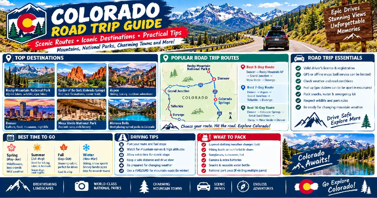
Colorado is the finest road trip state in the continental United States — a 104,094-square-mile landscape that concentrates more dramatic scenery, more drivable mountain passes, more designated scenic byways (26 state-designated byways, more than any other state), and more variety of terrain per mile than any comparable region in the country. Within a single day’s drive from Denver, a road tripper can move from the Great Plains grasslands of the eastern slope through a 14,000-foot alpine pass and down into the desert canyon country of the Colorado Plateau — a geological and ecological span that requires crossing six states anywhere else in the American West.
The state’s road trip infrastructure is exceptional: most of the major scenic routes are paved two-lane highways with maintained pullouts, interpretive signs, and reliable cell coverage (with the notable exception of specific canyon and wilderness sections); the highway system was engineered partly with scenic tourism in mind (US-550, the Million Dollar Highway, was literally built to expose travelers to the San Juan Mountains); and the concentration of national parks, monuments, and wilderness areas along the major routes means that every meaningful Colorado road trip intersects multiple protected landscapes.
What makes Colorado road tripping in 2026 different from previous years is the timed entry and reservation requirement that has been adopted by several of the most popular destinations on the standard routes — Maroon Bells (mandatory shuttle June 1–October 1), Rocky Mountain National Park (timed entry permit required May–October), and several canyon destinations now require advance planning that didn’t exist five years ago. This guide covers the six essential Colorado road trip routes, the best scenic byways, practical planning for 2026 conditions, and the logistics of doing Colorado by car in each season.
| Route | Miles | Duration | Best Season | Highlights |
|---|---|---|---|---|
| San Juan Skyway | 236 | 2–4 days | June–October | Ouray, Telluride, Silverton, Durango |
| Peak-to-Peak Highway | 55 | Half-day–1 day | Year-round | Rocky Mountain NP, Indian Peaks |
| Million Dollar Highway (US-550) | 75 | Half-day | June–October | Red Mountain Pass, Ouray ice climbing |
| Highway 12 / Scenic Byway | 124 | 1–2 days | May–October | Purgatory, Spanish Peaks, Taos connection |
| Grand Mesa Scenic Byway | 63 | Half-day | June–October | World’s largest flat-top mountain |
| Trail Ridge Road / Rocky Mountain NP | 48 | Half-day–1 day | Late May–October | Highest paved road in USA, 12,183 ft |
Miles: 236 | Loop from Durango | Duration: 2–4 days Season: June–October (US-550 over Red Mountain Pass open May; million dollar highway section can close after heavy snow) Best months: Late June–early October; peak fall color: late September
The San Juan Skyway is the finest single road trip loop in Colorado and one of the finest in the United States — a 236-mile circuit through the San Juan Mountains of southwestern Colorado connecting Durango, Silverton, Ouray, Ridgway, Telluride, Dolores, and Cortez in a loop that crosses three mountain passes above 10,000 feet, passes through six distinct mountain towns each with its own character, and traverses the most dramatic mountain scenery accessible by paved road in the lower 48 states.
The loop is typically driven counterclockwise from Durango: north on US-550 over Molas Pass (10,910 ft) and Red Mountain Pass (11,018 ft) through Silverton to Ouray; west on US-550 through Ridgway and CO-62 over Dallas Divide (8,970 ft) to Placerville; south on CO-145 through Telluride and Lizard Head Pass (10,222 ft); southeast through Dolores and Cortez; and north on US-160 back to Durango. Each segment has its own essential character.
Durango (base town, 6,512 ft): The finest base for the San Juan Skyway — a genuine Victorian railroad town on the Animas River with the Durango & Silverton Narrow Gauge Railroad (operating since 1882, one of the finest heritage railroads in North America; $99–$149 round-trip to Silverton, 3.5 hours each way), a thriving downtown (Main Avenue), and excellent lodging at all price points. Strater Hotel (699 Main Ave, $149–$299) is the finest historic hotel in Durango; the Rochester Hotel (721 E 2nd Ave, $129–$249) is the best boutique option.
US-550 north to Silverton (50 miles, 1 hour): The most spectacular section of the skyway — the climb out of Durango through the Animas River valley, over Molas Pass with views of the Needle Mountains (Grenadier Range, with peaks to 14,000 ft), and into Silverton. The Molas Pass overlook (10,910 ft, turnout on the right northbound) provides the finest panoramic view of the Needles accessible from the road.
Silverton (9,318 ft): The most authentically preserved 1880s mining town in Colorado — a single main street (Greene Street) of Victorian commercial buildings at the head of the Animas River valley, surrounded by 13,000-foot peaks, with a permanent population of 700 and no traffic lights. The town resisted tourist development longer than most San Juan mining towns; the result is a streetscape that requires minimal suspension of disbelief to imagine as 1893. Blair Street (the parallel street one block east) was the red-light district; the original wooden storefronts survive.
The Million Dollar Highway (Silverton to Ouray, 24 miles, US-550): The most dramatic road in Colorado and one of the most dramatic paved roads in the United States — a series of switchbacks, cliff-hugging ledges, and hairpin turns carved into the face of the San Juan Mountains with no guardrails on many sections, passing through three abandoned mining districts (Eureka, Animas Forks accessible by 4WD side trip) and over Red Mountain Pass (11,018 ft). The road earned its name variously: from the $1 million per mile construction cost, from the gold ore in the road fill, or from the irreplaceable views — accounts differ. Northbound is the more dramatic direction (the cliff drops are on the driver’s side; the views into the Uncompahgre Gorge are directly ahead).
Ouray (7,792 ft): The “Switzerland of America” — a small Victorian town in a nearly perfectly circular mountain bowl with peaks rising 3,000 feet on three sides. The Ouray Hot Springs Pool (1200 Main St, $20–$25/adult, year-round) is the finest natural hot springs pool in Colorado; the Box Canyon Waterfall and Park (Box Canyon Rd, $5) sends a trail through a narrow slot canyon directly under a 285-foot waterfall. The Ouray Ice Park (0.5 miles south on US-550, free, December–March) is the world’s largest man-made ice climbing park — 200 acres of irrigated ice columns in the Uncompahgre Gorge.
CO-62 West: Ridgway to Telluride (Dallas Divide, 8,970 ft): The drive over Dallas Divide on CO-62 provides the most photographed view in Colorado — the north face of the Sneffels Range (Mount Sneffels, 14,150 ft) reflected in a pond at the base of a hay meadow, with the full jagged San Juan ridgeline extending in both directions. The foreground pasture (privately owned, visible from the road pullout) has been photographed on virtually every serious Colorado landscape photography portfolio. Best light: morning, with the east-facing peaks in sun and the foreground meadow still in shadow.
Telluride (8,750 ft): The finest mountain town in Colorado — a box canyon with the main street (Colorado Avenue) dead-ending at the 365-foot Bridal Veil Falls (Colorado’s tallest free-falling waterfall, accessible by a 2-mile unpaved road) and the mountain gondola connecting the town to the Mountain Village resort above. The Telluride Film Festival (Labor Day weekend, tickets $30–$200, free outdoor screenings in Elks Park), Telluride Bluegrass Festival (June, $300–$450/4-day pass), and Telluride Jazz Festival (August) make Telluride the finest festival destination in Colorado. The Telluride ski area (2,000 acres, 4,425 ft vertical — the most vertical of any Colorado resort) is the finest in the state for those who care only about terrain quality.
CO-145 south through Lizard Head Pass (10,222 ft) to Dolores: The final leg of the skyway — a gentler descent through the Dolores River valley with Lizard Head (13,113 ft monolith, one of Colorado’s most technical summit climbs) visible from the highway. The Dolores River canyon (30 miles north of Cortez via CO-141) is a detour worth considering — a 150-mile canyon cut by the Dolores River through red sandstone with no development and no services, connecting to the Utah canyon country to the west.
Mesa Verde National Park (15 miles east of Cortez on US-160): A natural addition to the San Juan Skyway — the finest ancient cliff dwelling site in North America. The Cliff Palace (150 rooms, 23 kivas, largest cliff dwelling in North America; ranger-guided tour required, $5/person in addition to park entry $35/vehicle) and the Balcony House (accessed by ladder and crawlway, the most adventurous ranger tour in the park) are the essential stops. Full Mesa Verde visit: 4–6 hours.
Miles: 48 one-way (Estes Park to Grand Lake) | Duration: Half-day–full day Season: Late May – mid-October (weather dependent; can close any time for snow) Altitude: Maximum 12,183 ft (Fall River Pass) — highest paved through-road in the United States Entry: Timed entry permit required May–October ($2/vehicle in addition to $35 park fee); recreation.gov
Trail Ridge Road is the highest paved through-road in the United States and the finest alpine driving experience in the Rocky Mountain West — a 48-mile traverse of Rocky Mountain National Park from Estes Park on the east to Grand Lake on the west, spending 11 miles above 11,000 feet and 4 miles above 12,000 feet with unobstructed views of the Never Summer Range, the Mummy Range, and the Continental Divide. The road was constructed by the Civilian Conservation Corps and opened in 1932; it has been reconfigured but never fundamentally altered.
Key stops eastbound to westbound:
Wildlife: Trail Ridge Road provides the finest accessible wildlife viewing in RMNP — elk and mule deer are visible from the road year-round (elk rut in September is particularly spectacular; bull elk with full antler racks cross the road and bugle from the meadows within 100 feet of stopped cars); bighorn sheep frequent the Sheep Lakes area (CO-34, 3 miles inside the east entrance, $0 extra); pika (small alpine mammals, the finest climate-change indicator species in RMNP) are visible at the Alpine Visitor Center rock talus.
Miles: 55 one-way (Black Hawk to Estes Park) | Duration: Half-day Season: Year-round; fall color peak late September–early October Altitude: 8,000–9,000 ft throughout
The Peak-to-Peak Highway is Colorado’s oldest designated scenic byway (designated 1918) and the finest year-round mountain drive accessible from Denver — a 55-mile route along the eastern flank of the Front Range connecting Black Hawk (45 minutes from Denver on CO-119) to Estes Park, with constant views of the Indian Peaks (13,000–14,000 ft range), the Arapaho and Roosevelt National Forests, and the mining history of Gilpin and Boulder Counties. The road is entirely paved and open year-round (chains occasionally required in winter but rarely).
Essential stops:
Fall color: The Peak-to-Peak Highway through the aspen forest between Ward and Allenspark produces the finest roadside fall color in the Boulder-Denver day-trip range — typically peak the third week of September at 8,500–9,000 ft. The aspens line both sides of the road through long stretches between Ward and Peaceful Valley.
Miles: 124 (Trinidad to Taos, NM via CO-12 and US-64) | Duration: 1–2 days Season: May–October (passes can be icy in spring and fall) Altitude: Cucharas Pass (9,994 ft), La Veta Pass (9,413 ft)
Highway 12 is Colorado’s most underrated scenic byway — a 124-mile route through the Spanish Peaks (Dos Volcanes, 12,683 and 13,828 ft) and the Culebra Range connecting Trinidad on I-25 to the New Mexico border, with the finest combination of geology, history, and landscape of any Colorado byway. The Spanish Peaks are a pair of Miocene igneous intrusions surrounded by volcanic dikes — radial walls of harder rock extending up to 14 miles from the peaks like the spokes of a wheel, creating a landscape of parallel ridges and valleys unique in North America.
Key stops:
Miles: 63 (I-70 at Palisade to Delta on CO-92) | Duration: Half-day Season: June–October (closed or icy November–May) Altitude: Grand Mesa summit: 10,839 ft Entry fee: None
Grand Mesa Scenic Byway crosses the world’s largest flat-topped mountain — Grand Mesa, a 500-square-mile basalt-capped plateau rising from the Grand Valley at 4,600 feet to the mesa top at 10,839 feet in 23 miles, with 300+ lakes on the flat summit (the finest lake-density of any landform in the Rocky Mountain West), 200 miles of hiking trails, and the most complete change in ecology per vertical foot of any drive in Colorado (from high desert scrubland through Gambel oak, aspen, and spruce-fir forest to above-treeline alpine tundra within 23 miles).
Key stops:
Miles: 90 (Salida to Aspen via US-285 and CO-82) | Duration: Half-day–full day Season: Late May–October (Independence Pass closes November–late May) Peak: Independence Pass (12,095 ft) — the highest paved pass road in the United States open to through traffic Highlight connection: Links the Arkansas River Valley to the Roaring Fork Valley
The Collegiate Peaks Scenic Byway through Buena Vista and over Independence Pass is the finest high-pass drive in Colorado — the route that provides the most dramatic single transition from the eastern slope to the western slope of the Rockies, cresting at 12,095 feet above sea level with a 360-degree view of the Collegiate Peaks (Harvard, Yale, Columbia, Oxford, Princeton — 14,000-foot peaks named by a Yale geological survey party in 1869) before descending 4,000 feet to Aspen in 22 miles.
Key stops:
Location: Black Canyon of the Gunnison National Park, 15 miles east of Montrose Miles: 7 miles along the south rim | Stops: 12 overlooks | Entry: $30/vehicle The most dramatic short canyon drive in Colorado — the Black Canyon cuts 2,722 feet deep in 48 miles, with walls so steep that some sections receive only 33 minutes of direct sunlight per day. The south rim drive (7 miles from the visitor center to High Point) has 12 named overlooks; Painted Wall Overlook (the largest cliff face in Colorado, 2,250 ft, with pink pegmatite dikes creating a Jackson Pollock pattern) and Chasm View Overlook (narrowest canyon width, 1,100 ft at the rim, 40 ft wide at the river) are the two essential stops. The North Rim Road (unpaved, 8 miles from CO-92) provides the finest view across the canyon to the south rim.
Miles: 65 (Gunnison to Montrose) | Season: Year-round Blue Mesa Reservoir — Colorado’s largest body of water (9,180 acres, 20 miles long) — fills the Gunnison River valley between Gunnison and the Black Canyon. US-50 along the north shore is the finest lake-and-mountain drive in Colorado; the Elk Creek Marina (mile 31) and the Cimarron area (mile 61, with a display of narrow-gauge railroad equipment at the Cimarron Canyon bridge) are the essential stops.
Miles: 9.5 (Aspen to Maroon Lake) | Season: June–October; mandatory shuttle June 1–October 1 The most photographed road in Colorado — the 9.5-mile drive (or shuttle) from Aspen Highlands parking to Maroon Lake at the base of the Maroon Bells. The drive passes through the finest aspen groves in the Elk Mountains; peak fall color (late September) transforms the corridor into a gold tunnel.
Miles: 103-mile loop | Base: Cañon City | Season: Year-round A loop through the Wet Mountain Valley, the Sangre de Cristo front, and the Arkansas River canyon country connecting Cañon City, Cripple Creek (the last operating gold mine tour in Colorado, Mollie Kathleen Gold Mine, $30/person), Victor, and Florissant Fossil Beds National Monument (free, 34 million-year-old fossil trees and insect impressions in volcanic ash). The most complete geology, history, and landscape loop in southern Colorado.
Several essential Colorado destinations now require advance reservations:
| Route | Best Timing | Avoid |
|---|---|---|
| San Juan Skyway | Late June–early October | July 4 weekend (crowds), October after first snow |
| Trail Ridge Road | July–September | Late May–June (unstable weather); after October 1 (snow risk) |
| Peak-to-Peak Highway | Late September (fall color) | Holiday weekends (traffic from Denver) |
| Highway 12 | June–September | Spring (mud season, late April–May) |
| Grand Mesa Byway | August–September | Winter (closed) |
| Independence Pass | July–September | Before June 1 (typically closed) |
I-70 westbound from Denver to the ski resorts is the most congested highway in Colorado — plan your timing carefully:
Colorado has 24 paved mountain passes above 10,000 feet; the following require particular attention:
Day 1: Denver → Rocky Mountain National Park via US-36 through Boulder and Estes Park → Trail Ridge Road (Bear Lake timed entry permit required) → Grand Lake (overnight, $120–$200) Day 2: Grand Lake → Granby → Kremmling → Silverthorne via US-40 and I-70 → Breckenridge or Summit County (overnight, $180–$350 during peak season) Day 3: Breckenridge → Montezuma Ghost Town (4WD optional) → Loveland Pass (11,990 ft, spectacular views, no permit required) → I-70 east → Denver
Day 1: Denver → Durango via US-160 (7 hours), overnight in Durango Day 2: Durango → Silverton (50 miles, US-550) → Ouray (25 miles, Million Dollar Highway) → overnight Ouray Day 3: Ouray → Ridgway → Dallas Divide → Telluride (80 miles), overnight Telluride Day 4: Telluride → Lizard Head Pass → Dolores → Mesa Verde National Park (2 hours exploration) → Cortez (overnight) Day 5: Cortez → Durango via US-160 → return drive or fly from Durango Airport
Day 1: Denver → Rocky Mountain NP (Bear Lake, Trail Ridge Road) → Grand Lake Day 2: Grand Lake → Kremmling → Dotsero → Glenwood Springs (overnight; drive Glenwood Canyon, I-70 segment, one of the finest canyon highways in the US) Day 3: Glenwood Springs → Aspen via CO-82 (Maroon Bells if timed correctly, Independence Pass) → Aspen overnight Day 4: Aspen → Gunnison via CO-135 through Crested Butte → Blue Mesa Reservoir → overnight Gunnison or Montrose Day 5: Montrose → Black Canyon of the Gunnison → Ouray via US-550 → overnight Ouray Day 6: Ouray → Million Dollar Highway → Silverton → Durango → overnight Durango Day 7: Durango → Mesa Verde → return to Denver via I-25 (7 hours)
Posted By : Vinay
Latest Article
2nd Floor, 39, Above Kirti Club, DLF Industrial Area, Kirti Nagar, New Delhi, Delhi 110015



Travel Tourister is a leading Travel portal where we introduce travellers to trusted travel agents to make their journey hasselfree, memorable And happy. Travel Tourister is a platform where travellers get Tour packages ,Hotel packages deals through trusted travel companies And hoteliers who are working with us across the world. We always try to find new and more travel agents and hoteliers from every nook and corners across the world so that you could compare the deals with different travel agents and hoteliers and book your tour or hotel with the one you have chosen according to your taste and budget.
Copyright © Travel Tourister, India. All Rights Reserved

 Call
 Enquiry