Published on : 05 Aug 2026
By Travel Tourister | Updated Aug 2026
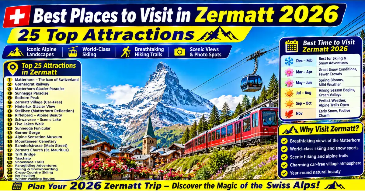
Zermatt is the single most visually iconic Alpine village in the world — a car-free community of approximately 5,800 permanent residents at 1,608 meters altitude in the Matter Valley of the Swiss Valais canton, surrounded by 38 peaks exceeding 4,000 meters, dominated by the Matterhorn (4,478 meters, the most recognizable mountain silhouette on Earth) whose near-perfectly pyramidal form appears on the village’s skyline from virtually every street and viewpoint in Zermatt itself. The best places to visit in Zermatt span the Matterhorn Glacier Paradise cable car (the highest cable car station in the Alps at 3,883 meters, delivering one of the most extraordinary high-altitude panoramas accessible to non-mountaineers anywhere in the world), the Gornergrat rack railway (ascending to 3,089 meters for what most photographers consider the definitive front-on Matterhorn view), the historic village churchyard (the cemetery of Alpine climbers who died attempting the surrounding peaks, maintained with quiet dignity beneath mature larch trees), and the Five Lakes Walk (the most beautiful day hike in the Alps by many accounts, connecting five high-altitude lakes each reflecting the Matterhorn from a different angle).
What makes Zermatt genuinely different from other Alpine resort villages is the combination of car-free authenticity (all private motor vehicles prohibited since 1947 — the village is served by electric taxis, horse-drawn carriages, and the Matterhorn Gotthard Bahn railway, creating a quiet and alpine-character-preserving environment that car-accessible resorts cannot match), the extraordinary concentration of Matterhorn views from practically every point in the village (the mountain is visible at the end of Bahnhofstrasse from the train station, from most restaurant terraces, from multiple hiking trail viewpoints, and even from certain bedroom windows), and the year-round operation that makes Zermatt equally rewarding in January’s deep ski-season winter and July’s hiking-season summer. This guide covers the 25 best places to visit in Zermatt with practical details — how to get there, what to pay, the best visiting times, and the insider knowledge that makes each experience genuinely rewarding rather than merely checked off a list.
For complete guides, see our Things to Do in Zermatt 2026, Best Restaurants in Zermatt 2026, Best Time to Visit Zermatt, Best Places to Visit in Switzerland 2026, and Switzerland Travel Guide 2026 guides.
| Place | Type | Entry Cost | Best For | Best Season |
|---|---|---|---|---|
| Matterhorn (views) | Natural Landmark | Free (village) | Iconic photography, inspiration | Year-round |
| Matterhorn Glacier Paradise | Cable Car | CHF 95–115 return | Highest Alps panorama, year-round skiing | Year-round |
| Gornergrat Railway & Summit | Rack Railway | CHF 55–95 return | Best Matterhorn front-on view, Monte Rosa | Year-round |
| Five Lakes Walk (Fünf-Seen-Wanderung) | Hiking | CHF 36–42 (Sunnegga gondola) | Most beautiful hike in the Alps | June–October |
| Chez Vrony & Findeln Hamlet | Mountain Restaurant | CHF 50–100 | Matterhorn view dining at altitude | June–October |
| Sunnegga Paradise | Cable Car / Area | CHF 27–36 (one-way/return) | Leisee lake, Matterhorn views, families | Year-round |
| Zermatt Village Bahnhofstrasse | Village | Free | Village atmosphere, shopping, history | Year-round |
| Alpine Museum (Alpines Museum) | Museum | CHF 10 | Matterhorn climbing history | Year-round |
| Mountaineers’ Cemetery | Cemetery / History | Free | Alpine climbing history, reflection | Year-round |
| Rothorn Paradise | Cable Car / Area | CHF 60–75 return | High ridge views, advanced hiking | June–October |
| Schwarzsee (Black Lake) | Lake / Cable Car | CHF 25–30 one-way | Closest accessible Matterhorn base | June–October |
| The Matterhorn Museum (Zermatlantis) | Museum | CHF 10 | Underground Matterhorn climbing history | Year-round |
| Riffelalp and Riffelberg | Rail Station / Area | CHF 20–30 (Gornergrat Railway stop) | Mid-mountain walks, views | June–October |
| Klein Matterhorn (Kleine Matterhornbahn) | Cable Car | Included in Glacier Paradise ticket | Highest aerial view in Alps | Year-round |
| Glacier Express Terminus | Railway | See Glacier Express ticket | Scenic railway arrival/departure | Year-round |
| Winkelmatten Chapel | Chapel / Village | Free | Historic chapel, Matterhorn backdrop | Year-round |
| Zmutt Valley (Zmutttal) | Valley / Walking | Free | Traditional hamlet, glacier views | June–October |
| Hinterdorf (Old Village) | Historic Quarter | Free | Traditional Valais architecture | Year-round |
| Visp/Täsch Connection | Transport Hub | CHF 15–20 (car park + shuttle) | Gateway understanding | Year-round |
| Riffelhorn | Rock Climbing / Walking | CHF 20–30 (rail access) | Closest rock to Matterhorn | June–October |
| Monte Rosa Massif Views | Mountain Views | Free (from village/trails) | Switzerland’s highest peak panorama | Year-round |
| Electric Taxi and Horse Carriage | Transport | CHF 15–30 per journey | Authentic village transport experience | Year-round |
| Stellisee | Lake | CHF 36–42 (Sunnegga gondola) | Best Matterhorn lake reflection | June–October |
| National Park Approach Trails | Hiking | Free | Wilderness hiking, chamois spotting | June–October |
| Matterhorn Glacier Trail | Glacier Walking | Free (trail); CHF 95+ (cable car) | Walk on a glacier, ice experience | June–October |
Entry: Free (to view from village) | Best Viewing Positions: Bahnhofstrasse (from the main street), Kirchplatz (church square), Matterhorn Museum area, Ried above the village | Best Time: Sunrise (alpenglow), sunset, clear mornings
The Matterhorn (4,478 meters) is the most photographed mountain in the world — its near-perfectly pyramidal four-ridged silhouette visible from Zermatt’s village center has appeared on Toblerone chocolate packaging, Swiss tourism materials, and global travel imagery for generations, creating a specific visual familiarity that the actual first encounter consistently exceeds rather than merely confirms. Standing in Zermatt’s Bahnhofstrasse and looking south at the Matterhorn — which fills the valley’s end like a framed painting regardless of where you’re standing — produces a visual impact that even experienced mountain travelers consistently describe as startling in its directness and scale.
The mountain’s four ridges (Hörnli, Zmuttgrat, Furggen, and Liongrat) each face a different cardinal direction, creating dramatically different visual profiles depending on viewing angle — the Hörnli ridge (the standard climbing route, first ascended in 1865 by Edward Whymper’s party with the tragic descent that killed four of the seven climbers) defines the view from Zermatt itself (the northeast face, showing the Matterhorn’s most famous and most photographed profile), while the Italian side (visible from Cervinia) presents a completely different, more massive silhouette. Zermatt’s specific view of the northeast face is the global reference image that essentially all Matterhorn imagery derives from.
The Matterhorn is famous not just visually but historically — the 1865 first ascent by Edward Whymper’s seven-person party, and the subsequent rope-break death of four team members on the descent (Douglas, Hadow, Hudson, and Croz — their names on graves in Zermatt’s Mountaineers’ Cemetery) created the defining narrative of Victorian Alpine tragedy that shaped public understanding of mountaineering for generations. This history saturates Zermatt — the Monte Rosa Hotel (where Whymper stayed before the ascent), the Alpine Museum (where artifacts from the climb are displayed), and the cemetery (where the graves of climbers killed on Matterhorn attempts span 160 years) all carry direct connection to the mountain’s human story alongside its visual impact.
Insider tips: The alpenglow (alpenglühen) — the pre-sunrise reddish illumination of the Matterhorn’s summit before direct sunlight reaches the valley, typically occurring 20–30 minutes before sunrise — is the single most extraordinary daily natural event in Zermatt. The summit turns deep red-orange against a still-dark sky for a brief 10–15 minute window before transitioning to normal daylight. The best alpenglow viewing position is the area around Ried (a small neighborhood 10–15 minutes’ walk north of the train station on the valley’s eastern slope) where the mountain faces directly without intervening valley walls. Set an alarm: the light window is brief and the Matterhorn’s color during alpenglow is unlike anything available at any other time of day.
Entry: CHF 95–115 return (from Zermatt) | Transport: Cable car sequence from Zermatt village (multiple gondola/cable car stages, approximately 45 minutes total ascent) | Best Time: Clear mornings, year-round | Altitude: 3,883 meters
The Matterhorn Glacier Paradise (Klein Matterhorn / Kleine Matterhornbahn) delivers visitors to 3,883 meters — the highest cable car station in the Alps, higher than the Jungfraujoch (3,454 meters) and providing views that encompass more than 38 peaks exceeding 4,000 meters simultaneously. At this altitude, the Matterhorn itself appears at almost equal height across the glacier basin — a perspective that ground-level and even mid-mountain viewpoints cannot replicate — while the Monte Rosa massif (Switzerland’s highest mountain group), the Grand Combin, and on exceptionally clear days Mont Blanc (France, 84 kilometers distant) complete a panorama that represents one of the most extraordinary mountain views accessible by cable car anywhere in the world.
The Summit Experience at Matterhorn Glacier Paradise includes an ice palace (a cavern system carved within the glacier ice, with ice sculptures maintained at constant below-freezing temperatures), the Glacier Lounge (a restaurant and viewing platform at the summit station), and the rooftop panoramic terrace (open air, genuine 3,883-meter altitude with the associated altitude effects — thin air, cold even in summer — that make this a genuinely high-altitude experience rather than a simulated one). Year-round skiing on the Klein Matterhorn glacier (the highest summer skiing destination in the Alps, with snow guaranteed year-round above 3,500 meters) makes the ascent equally rewarding in July as in January — the peculiarity of skiing in shorts weather while the valley bakes at 25°C below is one of Zermatt’s most specifically Alpine pleasures.
The cable car sequence from Zermatt involves three stages — the Gondelbahn Zermatt–Furi gondola, the Luftseilbahn Furi–Trockener Steg cable car, and the Luftseilbahn Trockener Steg–Matterhorn Glacier Paradise cable car — ascending through increasingly dramatic high-alpine terrain with the Matterhorn progressively approaching in the cable car window views.
Insider tips: The crossing to Cervinia, Italy (the Italian ski resort on the Matterhorn’s southern slope, reachable on skis or by the Theodul Glacier ski route in winter with a specific international day supplement to the lift pass) represents one of Europe’s genuinely extraordinary border-crossing experiences — skiing from Switzerland into Italy across a mountain pass, descending from 3,800 meters to Cervinia’s 2,050 meters on a single run of extraordinary vertical. In summer, non-skiers can take the cable car from the Matterhorn Glacier Paradise station down toward the Theodul Pass area for the cross-border experience without ski equipment.
Entry: CHF 55–95 return depending on season (higher in summer peak) | Transport: Bahn from Zermatt village center station (departure every 24 minutes, journey time 33 minutes to summit) | Best Time: Clear mornings; sunrise train in summer | Altitude: 3,089 meters
The Gornergrat rack railway (GGB — Gornergratbahn), operating since 1898 and one of the world’s highest open-air rack railways, ascends from Zermatt village station (1,608 meters) through a sequence of increasingly dramatic Alpine terrain to the Gornergrat summit (3,089 meters), where the Kulmhotel Gornergrat and the attached observatory terrace provide what most landscape photographers and Alpine enthusiasts identify as the definitive Matterhorn view — the mountain appearing directly across the Gorner Glacier basin in full front-face profile, the Monte Rosa massif (Switzerland’s highest mountain group, Dufourspitze 4,634 meters) extending to the east, and the full Gorner Glacier (Europe’s second-largest glacier after the Aletsch) filling the valley below in a landscape of glacial white and rocky peak that represents the quintessential Swiss high-alpine panorama.
The railway journey itself is a significant part of the experience — the 33-minute ascent passes through the Riffelberg area (2,582 meters, with excellent mid-mountain Matterhorn views from the station platform), the Rotenboden station (home of the famous Riffelsee reflection pool, see below), and continues upward through the final exposed ridge approach to the summit, with the Gorner Glacier visible below and the peak panorama expanding with each additional meter of altitude gained.
The Kulmhotel Gornergrat (the summit hotel and restaurant, one of the highest hotels in Switzerland at 3,089 meters, with rooms available for overnight stays providing sunrise Matterhorn photography conditions unavailable to day visitors) provides full-service restaurant dining with the Matterhorn directly across the glacier basin at eye level — arguably the most dramatic restaurant view in Switzerland.
Insider tips: The first morning train from Zermatt (departure varies by season — check current timetable) delivers visitors to the summit before the large tour groups that arrive on mid-morning trains — the Gornergrat summit at 8–9 AM on a clear summer morning (before the cloud build-up that afternoon sometimes brings) provides the panorama at its clearest and least crowded simultaneously. The GGB is partially included in the Swiss Travel Pass (significant discount, check current pass terms) — confirming the exact discount before purchasing individual tickets ensures optimizing pass value.
Entry: CHF 36–42 (Sunnegga gondola return) | Distance: 9.6 km | Difficulty: Moderate | Best Time: June–October | Start: Sunnegga (2,288 meters, top of Sunnegga gondola)
The Five Lakes Walk (Fünf-Seen-Wanderung) consistently ranks among Europe’s most beautiful hiking routes — a marked trail connecting five high-altitude lakes (Leisee, Grindjisee, Grünsee, Moosjisee, and Stellisee) above Zermatt, each lake reflecting the Matterhorn at a different angle and in a different foreground environment, creating five compositionally distinct Matterhorn photographs within a 9.6-kilometer circuit that most reasonably fit hikers complete in 4–5 hours at a comfortable pace. The trail’s combination of accessible difficulty (moderate elevation changes between lakes, no technical terrain, well-marked path) with extraordinary reward (the Matterhorn visible from essentially every point on the walk, with the lake reflections providing the specific photographic compositions that appear in most Zermatt photography guides) makes it the most consistently recommended single activity in Zermatt for hiking visitors.
Each lake has a distinct character: the Leisee (immediately below Sunnegga station, accessible with minimal walking — ideal for families with young children who want the Matterhorn view without the full hike), the Grindjisee (a slightly lower lake with a different foreground palette, the Matterhorn appearing over a ridgeline rather than rising directly from the water), the Grünsee (the “Green Lake,” with distinctive emerald water coloration from specific mineral content), the Moosjisee (a smaller pond with often glassy surface conditions), and the Stellisee (the highest and most celebrated of the five, at 2,537 meters, where the Matterhorn’s reflection appears in the lake surface on calm mornings — the single most sought-after photographic position in the Zermatt hiking network).
Insider tips: Morning calm (typically before 10 AM) provides the calmest lake surfaces for reflection photography — afternoon wind commonly disrupts the mirror-still conditions that the Stellisee reflection requires. Taking the first Sunnegga gondola (approximately 8:30 AM) and hiking to the Stellisee before 10 AM optimizes both reflection photography and the overall hiking experience before midday crowds arrive at the most popular viewpoints. The walk can be completed in either direction (Sunnegga start → Stellisee finish, or reverse via Rothorn cable car at Stellisee) — the Sunnegga start provides a more gradual warm-up before the most dramatic photographic locations appear later in the route.
Entry: CHF 27 (one-way) / CHF 36–42 (return) | Transport: Underground funicular from Zermatt village center (Sunneggabahn, ascent 4 minutes) | Altitude: 2,288 meters | Best Time: Year-round; families particularly suited here
Sunnegga Paradise, reached by a four-minute underground funicular ascent from the village center, provides Zermatt’s most immediately accessible elevated Matterhorn viewpoint — stepping out of the funicular station at 2,288 meters delivers the Matterhorn view at altitude with minimal physical effort, making this the ideal first Zermatt uplift experience and the most family-accessible high-viewpoint option. The Leisee (the lake immediately below the Sunnegga station, a short 10-minute walk from the funicular exit) adds the reflection dimension to the viewpoint, while the station’s sun terrace restaurants (Sunnegga Restaurant, the Café du Glacier) provide outdoor dining with direct Matterhorn views that justify a full morning or afternoon here independently of any hiking intentions.
Sunnegga functions as the starting point for the Five Lakes Walk (see above) and as the entry point to the Rothorn Paradise cable car sequence that ascends further to 3,103 meters — meaning the Sunnegga station serves as both an end-destination (for families and casual visitors wanting the view without strenuous hiking) and a transit point (for hikers and cable-car users ascending toward Rothorn or descending via various trail routes).
Insider tips: The Sunneggabahn (the underground funicular serving Sunnegga) departs from a station in the village center specifically designed to be inconspicuous — look for the funicular station entrance near the Zermatt Center area rather than expecting a prominently marked cable car building at street level. The funicular’s four-minute ascent through an underground tunnel (no mountain views during the ascent itself, which surprises first-time riders expecting an aerial gondola experience) delivers visitors directly to the outdoor viewpoint platform at Sunnegga in near-darkness → instant mountain panorama fashion that creates its own memorable reveal moment.
Entry: CHF 10 | Location: Kirchplatz, Zermatt village center | Hours: Daily, hours vary by season | Best Time: Year-round; essential for rain days
The Matterhorn Museum (officially “Zermatlantis” — the name referencing both the mountain and the underground museum’s descending, cave-like design) provides the most comprehensive single-institution account of Zermatt’s history — the village’s evolution from an isolated farming and herding community to one of the world’s most visited mountain resorts, the development of Alpine mountaineering as a distinct cultural practice, and specifically the 1865 first ascent of the Matterhorn and the catastrophic descent that defined the mountain’s public identity for generations. The museum’s design (a descending spiral through themed underground rooms, each covering a different aspect of Zermatt’s historical development) and its authentic artifacts (actual equipment from the 1865 first ascent, including the rope that broke during the descent — the defining artifact in the museum’s collection and one of the most historically significant single objects in the history of mountaineering) create a genuinely moving historical experience rather than a standard regional museum.
The rope fragment (displayed in its own dedicated case, the fraying at the break point visible, the implications of that fraying constituting one of mountaineering history’s most debated points — did it break from the strain of the fall, or was it cut deliberately?) anchors the museum’s most emotionally significant room, where the complete narrative of the 1865 ascent (including Whymper’s account, the identities and stories of the seven climbers, the sequence of events on the descent) is presented with appropriate historical seriousness.
Insider tips: The Matterhorn Museum pairs naturally with a visit to the Mountaineers’ Cemetery (see below) as a combined 2-hour Matterhorn history experience — the museum’s historical context deepens the cemetery’s emotional impact, while the cemetery’s physical presence (the actual graves of the men whose stories the museum tells) adds dimension to the museum’s narrative. This sequence (museum first, cemetery second) is the most rewarding order for this specific combination.
Entry: Free | Location: Adjacent to the Church of St. Mauritius, Zermatt village center | Best Time: Any time; quiet and reflective | Visiting: Respectful behavior appropriate (functioning cemetery)
Zermatt’s Mountaineers’ Cemetery, situated beside the historic Church of St. Mauritius in the village center and shaded by mature larch trees whose branches frame the grave markers against the Matterhorn visible beyond, contains the graves of Alpine climbers who died attempting the Matterhorn and surrounding peaks — beginning with the four men who died on the 1865 first-ascent descent (Douglas, Hadow, Hudson, and Croz, whose graves anchor the historical section of the cemetery) and extending through the subsequent 160 years of climbing history to recent decades. The graves’ simple iron crosses and stone markers, inscribed with names, nationalities, and often the specific ridge or face where each climber died, create a register of Alpine ambition and loss that functions simultaneously as historical record and as a genuinely affecting memorial space.
The international character of the cemetery (climbers from Britain, France, Germany, Italy, the United States, Japan, and dozens of other countries represented across the grave markers) reflects Zermatt’s century-and-a-half as a global mountaineering destination — the cemetery’s population represents every generation and every nationality that has been drawn to the Matterhorn’s specific combination of beauty and danger.
Insider tips: Reading specific individual graves (the biographical details on the markers — ages, home countries, and often the specific location where the climber died) creates a more personal connection to the cemetery’s meaning than simply walking through. The youngest graves (teenagers who died attempting routes beyond their experience level) are particularly affecting, as are the relatively recent markers that establish the Matterhorn’s continuing lethality despite modern equipment and route knowledge — approximately 500 people have died on the mountain since the first ascent.
Entry: Free (hamlet); restaurant costs apply | Access: On foot (45-minute walk from Zermatt) or Sunnegga gondola + 20-minute walk | Best Time: June–October | Altitude: 1,996 meters
Findeln, a traditional high-Alpine hamlet of timber chalets at 1,996 meters above Zermatt, provides the most authentic remaining example of the Zermatt area’s pre-tourism agricultural character — a handful of traditional Valais-style timber granaries and storage buildings (the characteristic raised-on-stone-pillar construction that keeps the structures above snow level and allows air circulation beneath) surrounding the two celebrated mountain restaurants (Chez Vrony and Findlerhof) that have made Findeln a destination in its own right. The hamlet sits on the slope above Zermatt with the Matterhorn directly visible across the valley — the specific view from Findeln (the mountain appearing at a slightly different angle than from the village center below) is considered by many photographers to be the finest reachable-on-foot Matterhorn perspective available without ascending to cable car altitude.
Chez Vrony (see our Best Restaurants in Zermatt guide for full detail) and the Findlerhof operate as Zermatt’s most celebrated mountain restaurants — the sun terrace lunch experience at either establishment (local Valais food at altitude, with the Matterhorn directly across the valley through the terrace’s southern exposure) represents the most specifically Zermatt dining experience available, combining the mountain environment with genuinely good food and wine in a way that village-level restaurants can’t replicate.
Insider tips: The walk to Findeln from Zermatt village (45 minutes uphill, a clearly marked trail from the village’s eastern residential area) is itself rewarding — the gradual ascent through the larch forest above the village provides progressively expanding views of the Matterhorn as altitude increases, while the Findeln hamlet’s arrival is preceded by the hamlet’s bell tower appearing through the trees. The downhill return (30–35 minutes) is significantly easier than the ascent and can be combined with a detour through the Winkelmatten neighborhood for a varied return route.
Entry: CHF 25–30 (cable car one-way from Furi) | Access: Cable car from Furi (itself reached by Gondelbahn from village) | Altitude: 2,583 meters | Best Time: June–October
Schwarzsee (the Black Lake, named for the dark appearance of its water under certain lighting conditions) sits at 2,583 meters in a dramatic position on the Matterhorn’s lower southeastern flank — the nearest accessible lake to the Matterhorn’s base, with the mountain’s ridges appearing close enough overhead that the scale relationship between the mountain and the lake shifts dramatically compared to the more distant views from Sunnegga or the village. The small chapel of Maria zum See (Our Lady of the Lake), a simple stone chapel at the lake’s edge that has served as both a place of worship and a waymarking point for climbers ascending the Hörnli Ridge (the standard Matterhorn climbing route), adds a specific human-history dimension to a location that might otherwise be purely scenic.
The Hörnli Hut (the high-altitude mountain hut at 3,260 meters where Matterhorn climbing teams spend the night before their summit attempt, operated by the Swiss Alpine Club) is visible above the Schwarzsee on clear days — a tangible connection between the scenic cable-car visitor landscape and the serious mountaineering world that the Matterhorn still demands from those who attempt it beyond the cable car level.
Insider tips: The Glacier Trail (Gletscherweg, a marked hiking route beginning from the Schwarzsee area and descending toward the Matterhorn Glacier Paradise region) allows experiencing actual glacier terrain on foot — the route crosses lateral moraine from the Matterhorn glacier system, providing a physically close encounter with glacial geology and remnant ice that lower-altitude trails don’t provide. Trail conditions should be checked with Zermatt Tourism before attempting (the glacier environment changes annually as the glaciers retreat).
Entry: CHF 60–75 return (Sunnegga to Rothorn Paradise cable car) | Altitude: 3,103 meters | Best Time: June–October | Access: Cable car sequence from Sunnegga
Rothorn Paradise (3,103 meters), reached by a cable car ascent from the Sunnegga area, provides Zermatt’s highest panoramic platform accessible by cable car above the Sunnegga level (below the Matterhorn Glacier Paradise at 3,883 meters) — the summit platform and restaurant deliver views that encompass the entire Zermatt area’s mountain landscape: the Matterhorn directly across, the Monte Rosa group to the southeast, the Weisshorn and Zinalrothorn to the northwest, and the full Gorner Glacier basin visible below. The Rothorn Paradise also serves as the high point for several advanced hiking routes across the ridge system above the Five Lakes Walk — experienced hikers can traverse from Rothorn toward the Mettelhorn (3,406 meters) via maintained trails that provide summit-adjacent experiences without full mountaineering commitment.
Insider tips: The Rothorn Paradise–Sunnegga–Zermatt combination (ascending to Rothorn for the panorama, then hiking down to Sunnegga via the Five Lakes Walk route and taking the funicular back to the village) creates a comprehensive half-day circuit that combines the highest aerial view available at this cable car level with the most celebrated walk in the area — a logical efficient combination for visitors with active hiking interests.
Entry: CHF 55–95 (Gornergrat Railway to Rotenboden station) | Location: Rotenboden station, Gornergrat Railway | Best Time: Morning, calm conditions | Access: Alight Rotenboden station (the stop below Riffelberg)
The Riffelsee (Riffel Lake) at the Rotenboden station of the Gornergrat Railway (approximately 2,750 meters) is arguably the most famous single photographic location in Switzerland — a small high-altitude lake whose glassy surface reflects the Matterhorn in a near-perfect mirror image when morning winds haven’t disturbed the surface, creating the double-Matterhorn composition (mountain above, reflection below, perfectly symmetrical) that appears in more Zermatt/Switzerland imagery than any other single location. The “Matterhorn in the Riffelsee” photograph is Switzerland’s most reproduced single travel image, and standing at the lake’s edge on a calm morning with the actual reflection visible produces the specific satisfaction of encountering a famous image in its actual physical context.
Insider tips: The Riffelsee is at its most photographic on calm mornings (before approximately 10 AM, when wind typically begins disturbing the surface) and specifically in conditions where the Matterhorn is clearly visible (not shrouded in cloud, which is common by mid-afternoon). Alighting specifically at Rotenboden station (one stop below Riffelberg, two stops below Gornergrat summit) rather than continuing to the summit is necessary — the Riffelsee is not visible from either the summit or the Riffelberg area, and many visitors miss it entirely by failing to alight at the right station. The 15-minute walk from Rotenboden station to the lake’s most photographic position is clearly marked and flat.
Entry: Free | Location: Village center, from the train station south toward Kirchplatz | Best Time: Morning (quieter) or evening (lit shop windows, Matterhorn at alpenglow) | Year-round
Zermatt’s Bahnhofstrasse (the main pedestrian street connecting the train station to the village center) is perhaps the most visually distinctive main street of any Alpine resort village — lined with a mixture of traditional Valais wooden chalet buildings (the oldest dating to the 17th and 18th centuries, some now converted to shops and restaurants while maintaining original exterior character), modern resort hotel lobbies, ski and mountain sport retailers, chocolate and souvenir shops, and the electric taxis and horse-drawn carriages that have replaced conventional vehicles since 1947’s car ban. The Matterhorn is visible at the southern end of the street as a natural terminus to the view — an architectural accident (or perhaps not entirely accidental village planning) that makes Bahnhofstrasse the only major retail street in the world where the view terminates in the world’s most recognizable mountain.
Insider tips: Evening on Bahnhofstrasse (after the lift systems have closed and ski-boot-clattering day visitors have retreated to their hotels for dinner) provides the most characterful experience of the village street — the pedestrian-only environment with electric taxis gliding silently past, the warm light spilling from restaurant and shop windows, and the Matterhorn appearing at the street’s southern end in alpenglow or early-evening darkness creates the specific charm that makes Zermatt a genuine village rather than purely a resort service infrastructure.
Entry: Free | Location: Eastern side of village center | Best Time: Anytime; morning light best for photography | Year-round
Hinterdorf (the “rear village” — historically the oldest settled area of Zermatt, predating the tourism-driven development of the main Bahnhofstrasse axis) contains the most concentrated collection of traditional Valais architectural structures in Zermatt — the characteristic log-and-stone constructions (mazots, traditional Valais storage buildings with stone mushroom caps beneath the posts to prevent rodent access to stored grain, elevated on stone pillars to protect contents from snow and floods) and residential chalets dating from the 17th through early 19th centuries that represent Zermatt as it existed before the English climbers and Swiss hoteliers began transforming it into a resort in the mid-19th century.
The narrow lanes of Hinterdorf, with their timber-framed structures darkened to near-black by centuries of weathering, are genuinely different in character from the resort infrastructure of Bahnhofstrasse — a specifically pre-tourism architectural environment that provides tangible evidence of the village’s agricultural origins before mountaineering demand transformed its economy.
Insider tips: The Hinterdorf area is most clearly differentiated from the modern resort architecture in the morning light — approaching from the village center toward the church (St. Mauritius Church, adjacent to the Mountaineers’ Cemetery) and then turning into the Hinterdorf lanes (east of the church) provides the most complete transition from modern resort to traditional village within a short walking circuit.
Entry: Free | Access: On foot from Zermatt village (approximately 45 minutes to Zmutt hamlet, easy valley-floor walk) | Best Time: June–October | Altitude: 1,936 meters
The Zmutt Valley (Zmutttal), extending northwest from Zermatt village toward the Zmutt Glacier and the western face of the Matterhorn, provides access to Zermatt’s most authentically pre-tourist landscape — the traditional hamlet of Zmutt (1,936 meters, approximately 45 minutes’ walk from the village center along a clearly marked and relatively flat valley-floor path) consists entirely of traditional Valais-style timber buildings (no hotel, no restaurant infrastructure beyond the simple Gästehaus Zmutt guesthouse), with the western Matterhorn face appearing above the valley in a form quite different from the northeast face visible from the main village.
The Zmutt valley walk also provides excellent chamois (the Alpine goat-antelope, the unofficial symbol of Zermatt’s wildlife population) sighting opportunities — the valley’s quieter character (fewer visitors than the cable-car-accessible areas) encourages wildlife presence that the busier eastern slopes don’t support.
Insider tips: The Zmutt valley extension (continuing beyond the hamlet toward the Schönbühlhütte mountain hut at 2,694 meters, approximately 2.5 hours from Zermatt) provides a more ambitious hiking destination within the same valley — the views of the western Matterhorn face from the Schönbühlhütte area are dramatically different from any cable-car-accessible viewpoint and represent the Matterhorn’s genuinely intimidating scale when experienced at close range from below rather than at equivalent altitude from across a glacier basin.
Entry: Free | Location: Winkelmatten neighborhood, south of Zermatt village center | Best Time: Morning light, clear days for Matterhorn backdrop | Year-round
The Winkelmatten Chapel (a small Baroque chapel in the Winkelmatten neighborhood, approximately 10 minutes’ walk south of the main village center), with the Matterhorn rising directly behind it, constitutes one of Switzerland’s most photographed single architectural compositions — the combination of the small stone chapel’s human scale, the traditional Alpine village character of the surrounding chalets, and the Matterhorn’s summit appearing directly above the chapel spire creates a specifically Alpine narrative composition that appears in photography guides, tourism materials, and travel imagery from every era since photography reached Zermatt in the 19th century.
Insider tips: The chapel’s most photogenic position (from the northeast, with the chapel centered in the frame and the Matterhorn directly behind) requires positioning approximately 50 meters northeast of the chapel building itself — closer approaches put the chapel too far below the mountain in the composition, while the specific distance (approximately 50 meters) places both chapel and summit at their most balanced scale relationship within a standard camera framing. Morning light (when the eastern-facing chapel and the northeast Matterhorn face both catch the first direct sunlight) provides the most favorable illumination for this composition.
Entry: Glacier Express ticket (from CHF 175 standard, or Swiss Travel Pass + seat reservation CHF 13–49) | Departures: From Zermatt station (the westernmost terminus of the Glacier Express route) | Duration: 7 hours 45 minutes to St. Moritz | Book: Seat reservation required
Zermatt station serves as the western terminus of the Glacier Express — Switzerland’s most famous scenic railway, running through 291 bridges and 91 tunnels across 291 kilometers to St. Moritz in a 7-hour-45-minute journey through the Swiss Alps. Departing from or arriving into Zermatt by Glacier Express provides the most atmospheric rail arrival/departure in Switzerland — the train’s panoramic cars delivering views of the Matterhorn (visible from the right side of the train departing eastbound from Zermatt for the first 10–15 minutes) transitioning to the Valais valley landscapes and eventually the Graubünden mountain scenery of the route’s middle and eastern sections.
Insider tips: Arriving in Zermatt by Glacier Express (departing from St. Moritz in the morning, arriving Zermatt early-to-mid afternoon) provides the specific pleasure of the Matterhorn appearing gradually as the train approaches through the Mattertal valley — the mountain first appearing as a distant pyramid and growing progressively larger as the train curves into the final approach to Zermatt station. This arrival experience (from the train window) differs completely from the arrival by standard express train from Visp/Brig, which delivers visitors to the station without the extended mountain-approach view.
Entry: CHF 20–30 (Gornergrat Railway to Riffelalp station) | Altitude: 2,211 meters | Best Time: May–October | Access: Alight at Riffelalp station (first stop above Zermatt on Gornergrat Railway)
Riffelalp (2,211 meters), the first station stop on the Gornergrat Railway above Zermatt village, provides a mid-mountain terrace environment that functions as both a hiking base and a standalone destination — the Riffelalp Resort (a luxury hotel at this elevation, one of the highest-altitude hotels in the Alps accessible by rack railway) and the surrounding meadow landscape (larch forests, Alpine wildflowers in July–August, and the specific mid-mountain atmosphere where resort infrastructure dissolves into genuine wilderness within minutes’ walk) create a plateau environment more intimate than the exposed summits above while more dramatically elevated than the village below.
Insider tips: The Riffelalp to Riffelberg hiking section (an approximately 1-hour ascent on a marked trail continuing from Riffelalp toward Riffelberg at 2,582 meters) provides one of Zermatt’s most rewarding mid-mountain walks — gaining 370 meters of elevation through changing vegetation zones (larch forest to open Alpine meadow) with the Matterhorn progressively expanding in the view, without the commitment of a full summit approach.
Entry: Free (to view from Zermatt area) | Best Viewing: Gornergrat summit, Stockhorn (from Matterhorn Glacier Paradise), valley floor | Best Time: Clear days, morning
The Monte Rosa Massif — the group of peaks on Zermatt’s eastern horizon including the Dufourspitze (4,634 meters, Switzerland’s highest point and the highest peak in the Alps outside of Mont Blanc), the Nordend, the Zumsteinspitze, and multiple other four-thousanders — provides one of the world’s most concentrated collections of extremely high mountains visible from a single valley-floor viewpoint. The Gorner Glacier (descending from the Monte Rosa toward the Gorner Gorge below the Gornergrat) provides the visual foreground connection between the valley and the massif, creating landscape compositions where glacier, rock, and sky combine in scales that challenge normal human visual reference.
Insider tips: Monte Rosa’s specific identity (Switzerland’s highest point, frequently overshadowed in global recognition by the Matterhorn despite greater altitude) makes it worth specific attention on a Gornergrat visit — identifying the Dufourspitze specifically (the highest of the Monte Rosa peaks, visible from the Gornergrat summit as the rightmost of the massif’s main peaks) adds geographical context to the panoramic view’s otherwise overwhelming scale.
About Travel Tourister Travel Tourister’s destination specialists have explored Zermatt across all seasons — from alpenglow Matterhorn mornings and Stellisee reflection hikes to Gornergrat summit snowshoeing and Whymper Stube fondue evenings — to deliver the most practical and honest guide to the best places to visit in Zermatt for every type of 2026 visitor.
Posted By : Vinay
Latest Article
2nd Floor, 39, Above Kirti Club, DLF Industrial Area, Kirti Nagar, New Delhi, Delhi 110015



Travel Tourister is a leading Travel portal where we introduce travellers to trusted travel agents to make their journey hasselfree, memorable And happy. Travel Tourister is a platform where travellers get Tour packages ,Hotel packages deals through trusted travel companies And hoteliers who are working with us across the world. We always try to find new and more travel agents and hoteliers from every nook and corners across the world so that you could compare the deals with different travel agents and hoteliers and book your tour or hotel with the one you have chosen according to your taste and budget.
Copyright © Travel Tourister, India. All Rights Reserved

 Call
Call Enquiry