Published on : 31 Oct 2026
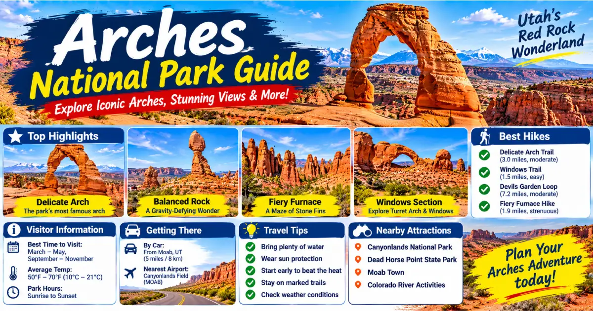
Arches National Park contains the highest density of natural stone arches on Earth — more than 2,000 documented arches within 76,679 acres of southeastern Utah desert, ranging from narrow slits barely three feet wide to Landscape Arch, a gossamer ribbon of sandstone spanning 306 feet that is the longest natural arch in North America. The park sits on the Colorado Plateau just north of Moab, where the salt-driven collapse of underground evaporite deposits cracked and buckled the overlying Entrada Sandstone into the fins, spires, and windows that erosion has subsequently carved into arches over the past 100 million years. No other landscape on Earth produces natural stone arches at this scale and concentration, and no photograph — however technically accomplished — fully conveys what it feels like to stand beneath Delicate Arch as the last light turns the sandstone from gold to red to deep copper.
Arches is one of the most popular national parks in the country, and 2026 visitation is projected to exceed 1.8 million people in the April–October season. The park implemented a timed-entry permit system in 2022 that remains in effect: from April 1 through October 31, all vehicles entering between 6 AM and 5 PM require a timed-entry permit ($2/vehicle, in addition to the $35/vehicle entry fee), reserved at recreation.gov up to three months in advance. Without a permit, you must arrive before 6 AM or after 5 PM — both of which happen to be the finest times of day to experience the park anyway, with the pre-dawn light on the sandstone fins and the post-5 PM golden hour drawing photographers from around the world.
What makes Arches extraordinary is not just the arches themselves — remarkable as they are — but the total landscape: the red Entrada Sandstone glowing against blue desert sky, the distant La Sal Mountains holding snow into June, the pinyon-juniper woodland across the canyon bottom, and the Colorado River corridor visible from the high viewpoints. The park is compact (the main scenic drive is 18 miles one way with a dead end), the trails are relatively short and well-maintained, and the density of extraordinary geological features per square mile is unmatched anywhere in the national park system. A first-time visitor can see the park’s greatest highlights in a single full day; returning visitors know that Arches rewards every subsequent visit with new light, new perspectives, and new appreciation for the improbable fragility of stone shaped by millions of years of patient erosion.
| Category | Detail |
|---|---|
| Park entrance fee | $35/vehicle (7-day pass) |
| Timed-entry permit | $2/vehicle, required Apr 1–Oct 31, 6 AM–5 PM, recreation.gov |
| Park size | 76,679 acres |
| Number of arches | 2,000+ documented |
| Longest arch | Landscape Arch, 306 feet span |
| Most iconic arch | Delicate Arch, 52 feet tall |
| Best hike | Delicate Arch Trail (3 miles RT, 480 ft) |
| Best easy walk | Windows Section loop (1 mile) |
| Best sunrise | Park Avenue or Balanced Rock |
| Best sunset | Delicate Arch upper viewpoint |
| Nearest city | Moab, Utah — 5 miles south |
| Nearest airport | Grand Junction Regional (GJT), 110 miles northeast |
| Best season | March–May, September–November |
The arches of Arches National Park form through a three-stage geological process unique to this corner of the Colorado Plateau. First, the Paradox Basin — a vast underground evaporite deposit of salt and potash laid down 300 million years ago — began dissolving and collapsing under the weight of overlying sediments, fracturing the Entrada Sandstone above into parallel sets of vertical cracks. These fractures created the fins (narrow, blade-like ridges of sandstone) visible throughout the park. Second, water — rain, snowmelt, and frost-wedging — worked along the fractures in the fins, gradually eroding windows through the thinner sections. Third, gravity and continued weathering widened those windows, creating the arches.
The Entrada Sandstone (150 million years old) that forms most of the park’s arches was deposited as ancient sand dunes in a Sahara-like desert during the Jurassic period. It is relatively soft and susceptible to erosion, which is why arches form here rather than in harder rock — but it also means the arches are constantly changing. Wall Arch (71-foot span) collapsed overnight in August 2008, leaving a rubble pile on the Devils Garden trail. Landscape Arch dropped three large slabs in 1991, 1995, and 2008; its span has narrowed and thinned to just 6 feet at its thinnest point. The arches are temporary geological features, and standing beneath one is to observe an object in the middle of its millennial lifespan.
Park Avenue — 1 mile from the entrance station — is the first major stop on the scenic drive and one of the finest introductions to Entrada Sandstone geology anywhere in the park: a valley flanked by sheer sandstone walls rising 300 feet, resembling the canyon of a city street (hence the name). The Park Avenue Trailhead (at the north end of the one-way section) leads to a 2-mile one-way trail (best walked south to north with a car shuttle, or 4 miles RT) through the canyon past the Courthouse Towers — massive sandstone monoliths named the Organ, the Tower of Babel, and the Three Gossips. This is the finest easy valley walk in the park and the best place to appreciate the scale of the Entrada Sandstone cliffs. Sunrise here illuminates the western wall while the eastern wall stays in shadow — the contrast is dramatic.
Balanced Rock — 8 miles from the entrance — is the park’s most improbable roadside feature: a 3,577-ton boulder of Entrada Sandstone balanced on a 73-foot pedestal of softer Dewey Bridge mudstone, the whole assembly standing 128 feet tall. The Balanced Rock Trail (0.3 miles, entirely flat, the most accessible trail in the park) circles the base; the view of Balanced Rock against the Windows Section fins to the east and the La Sal Mountains to the southeast is one of the park’s signature images. A companion formation called Chip Off the Old Block stood next to Balanced Rock until 1975, when it collapsed — a reminder that these formations are transient.
The Windows Section — 2.5 miles east of Balanced Rock on a spur road — contains the highest concentration of large arches accessible by short walks anywhere in the park. The North Window (51-foot span) and South Window (105-foot span) are visible from the same viewpoint and frameable in a single photograph from the primitive loop trail. The Windows Loop (1 mile, flat, accessible) visits both windows and Turret Arch (a double arch with a smaller window above the main span). The Double Arch — a separate trailhead 0.5 miles from the Windows parking area — is the most dramatic close-range arch experience in the park: two arches sharing a common abutment, the larger spanning 148 feet and rising 112 feet above the canyon floor, the second arch spanning 60 feet. Standing beneath Double Arch and looking up through both spans simultaneously is one of the most vertiginous architectural experiences in nature. The Windows Section trails take 1–2 hours total and are the best option for visitors with limited time or mobility.
Between the Windows turnoff and Delicate Arch Road, the Garden of Eden Viewpoint pulls out to the east offering some of the finest views of the Salt Valley — the collapsed salt anticline that forms the broad, flat basin at the heart of the park — and the Fiery Furnace to the north. Several unnamed arches and windows are visible in the sandstone fins from this pullout.
Two roadside Delicate Arch Viewpoints (Lower and Upper, both on the Delicate Arch Road spur, 11 miles from the entrance) allow visitors who cannot hike the full trail to see Delicate Arch at distance. The Lower Viewpoint (0.5 miles RT, flat) shows the arch as a tiny orange frame against the sky, 1.5 miles away. The Upper Viewpoint (1.5 miles RT, 100 ft elevation gain) is significantly closer and the arch is visible at a scale where its form and proportions are legible. Neither viewpoint substitutes for the hike — from the viewpoints, Delicate Arch is a distant feature; from the trail, it is an overwhelming presence — but they are valuable for visitors with mobility limitations.
The Fiery Furnace is the most labyrinthine section of the park — a 3-mile-long maze of narrow sandstone canyons, slots, and fins where the trails are unmarked and navigation requires genuine route-finding skill. The name comes from the way the fins glow orange-red in the late afternoon light. Access is restricted to ranger-led tours ($16/adult, reservations required at recreation.gov, sells out weeks in advance May–September) or self-guided permits ($10/person, requires watching a 30-minute orientation video and demonstrating basic navigation competence). The Fiery Furnace ranger tour is one of the finest guided natural history experiences in the national park system — rangers lead groups of 25 through 1.5 miles of slot canyons, crawl-through passages, and hidden chambers, explaining the geology, ecology, and archaeology of the formation. Book as early as possible.
The Delicate Arch Trail is the signature hike of Arches National Park and one of the most iconic short hikes in America — a 3-mile round trip from the Wolfe Ranch Trailhead (11 miles from the park entrance) ascending 480 feet across open slickrock, through a narrow sandstone canyon, and onto the broad bowl of slickrock where Delicate Arch stands, entirely alone, at the edge of a 150-foot drop into a canyon of the Colorado River drainage.
Delicate Arch itself is 52 feet tall and 46 feet wide at its base — larger than it looks in photographs, which lack a human scale reference. The arch stands on the rim of a natural slickrock bowl; visitors typically walk around the bowl’s left edge on a narrow ledge (some exposure, but not technically difficult) to reach the base and the framing viewpoint. The standard photograph — arch in foreground, La Sal Mountains in background — is taken from the bowl’s rim, 50 feet from the arch.
Trail details: The first mile is flat to gently rolling; the second half ascends open Entrada Sandstone slickrock marked by cairns. There is no shade for the entire route and no water below the trailhead. Bring 2 liters minimum; more in summer. The trail is exposed and hot from 9 AM to 5 PM in summer (90–100°F on the slickrock); the finest times are pre-dawn (start 90 minutes before sunrise to arrive as the arch turns gold) and late afternoon (arrive 2 hours before sunset to catch the full golden hour and sunset light on the arch — the most photographed and most emotionally powerful experience in the park).
At the trailhead: The Wolfe Ranch (0.3 miles into the trail on a short spur) is a remarkably intact 1888 homestead — a Civil War veteran named John Wesley Wolfe ranched here with his family for 12 years, and the log cabin, root cellar, and corral survive. A panel of Ute petroglyphs (200–700 years old) is visible on the canyon wall 100 yards past the ranch on a signed spur — the finest Native American rock art accessible to day hikers in the park.
Devils Garden — at the end of the 18-mile scenic drive — contains the largest concentration of named arches accessible by trail in the park: Landscape Arch, Partition Arch, Navajo Arch, Wall Arch (collapsed 2008), Double O Arch, Dark Angel, and Private Arch, among others. The trail is structured so that any visitor can tailor the distance to their ability:
Already covered under the Windows Section — the finest short hike in the park for families, first-time visitors, or those with limited time. North Window, South Window, Turret Arch, and Double Arch together represent the park’s most accessible concentration of major arches. Allow 1–1.5 hours for all four features.
Sand Dune Arch (accessed via a slot canyon, 0.4 miles RT, almost entirely shaded) is the finest hot-weather hike in the park — the narrow slot keeps temperatures 20°F cooler than the open desert, and the sandy floor of the arch chamber is a perfect rest stop. A campground spur connects to Broken Arch (1.2 miles RT from the campground, through open meadow — not actually broken, just a gap in the capstone that looks broken from a distance), making a 2.4-mile loop through the campground. Best combined with a Devils Garden visit.
Not a maintained trail, but the Courthouse Wash petroglyph panel — visible from the road where the main park road crosses Courthouse Wash (1 mile from the entrance), accessible via a 0.5-mile sandy wash walk — is the finest and most extensive rock art site in the park: a large panel of Barrier Canyon–style pictographs (2,000–4,000 years old, attributed to the Archaic culture) painted in red ochre on a 50-foot sandstone wall. The panel was vandalized with household cleaners in 1980 but partially restored by the NPS; what remains is still remarkable. Walk down the wash from the road-crossing parking pullout.
Arrive at park entrance by 5:45 AM (before 6 AM permit requirement, or with advance permit). Drive directly to Delicate Arch Trailhead. Hike to Delicate Arch for sunrise (3 miles RT, 2 hours). Return to car; drive to Windows Section. Walk the Windows Loop and visit Double Arch (1.5 hours). Drive back through the park, stopping at Balanced Rock for photos (15 minutes). Exit before the midday heat.
Start at 5:30 AM at Park Avenue Trailhead for sunrise on the Courthouse Towers. Drive to Balanced Rock (photos, 15 minutes). Continue to Windows Section — complete the Windows Loop and Double Arch (1.5 hours). Drive to Delicate Arch Trailhead — lunch at the parking area, then hike to Delicate Arch in late afternoon (depart trailhead by 3:30 PM for a 5:30 PM arrival in sunset light). Spend 30–60 minutes at the arch for golden hour and sunset colors. Return to Moab after dark.
Day 1: Start at dawn — Park Avenue and Courthouse Towers (1 hour). Windows Section — full loop including Double Arch (2 hours). Midday rest in Moab (the 90°F desert is inhospitable between 11 AM and 3 PM in summer). Afternoon — Delicate Arch hike, arriving for golden hour and sunset (depart trailhead 3 PM). Evening in Moab: dinner at Desert Bistro ($28–55, finest restaurant in Moab, reservations essential) or Pasta Jay’s ($14–22, longtime local favorite).
Day 2: Pre-dawn start — drive to Devils Garden (end of scenic drive). Sunrise at Landscape Arch (1.6 miles RT, done before 7 AM). Continue the full Devils Garden Loop (7.2 miles RT, finish by noon). Afternoon: Fiery Furnace ranger tour (if booked in advance, 2.5 hours) or drive to Balanced Rock for sunset photography. Evening: star gazing from the Windows Section parking area (Arches has minimal light pollution, the Milky Way is visible on moonless nights).
Flora: The park’s high desert ecosystem (4,085–5,653 feet elevation) supports cryptobiotic soil crust — the dark, lumpy biological crust of cyanobacteria, algae, fungi, and mosses that stabilizes the desert soil and takes 50–250 years to recover from a single footstep. Stay on the trail and on slickrock — the “don’t walk on the crust” signs are the most important conservation message in the park. Blackbrush, Mormon tea, four-wing saltbush, and juniper dominate the lower elevations; pinyon pine and Utah juniper form the pygmy forest of the canyon country.
Wildlife: Desert bighorn sheep (regularly seen near the Windows Section and on canyon walls along the scenic drive — introduced in 1985, now numbering 200+), mule deer (common in the Devils Garden area at dawn and dusk), peregrine falcons (nesting on the sandstone walls, visible soaring), canyon wrens (the most beautiful birdsong in the desert — a descending cascade of clear notes echoing from sandstone walls), collared lizards (electric green and orange, on warm rocks), Great Basin rattlesnakes (present, rarely seen on maintained trails), and ringtail cats (nocturnal, seen near Devils Garden Campground at night).
Camping:
Lodging in Moab (5 miles from park entrance):
Moab has 50+ hotels and lodges; book 3–6 months in advance for April–May and September–October, the peak seasons.
Food and drink in Moab:
Getting there:
When to visit:
Posted By : Vinay
Latest Article
2nd Floor, 39, Above Kirti Club, DLF Industrial Area, Kirti Nagar, New Delhi, Delhi 110015



Travel Tourister is a leading Travel portal where we introduce travellers to trusted travel agents to make their journey hasselfree, memorable And happy. Travel Tourister is a platform where travellers get Tour packages ,Hotel packages deals through trusted travel companies And hoteliers who are working with us across the world. We always try to find new and more travel agents and hoteliers from every nook and corners across the world so that you could compare the deals with different travel agents and hoteliers and book your tour or hotel with the one you have chosen according to your taste and budget.
Copyright © Travel Tourister, India. All Rights Reserved

 Call
 Enquiry