Published on : 30 Oct 2026
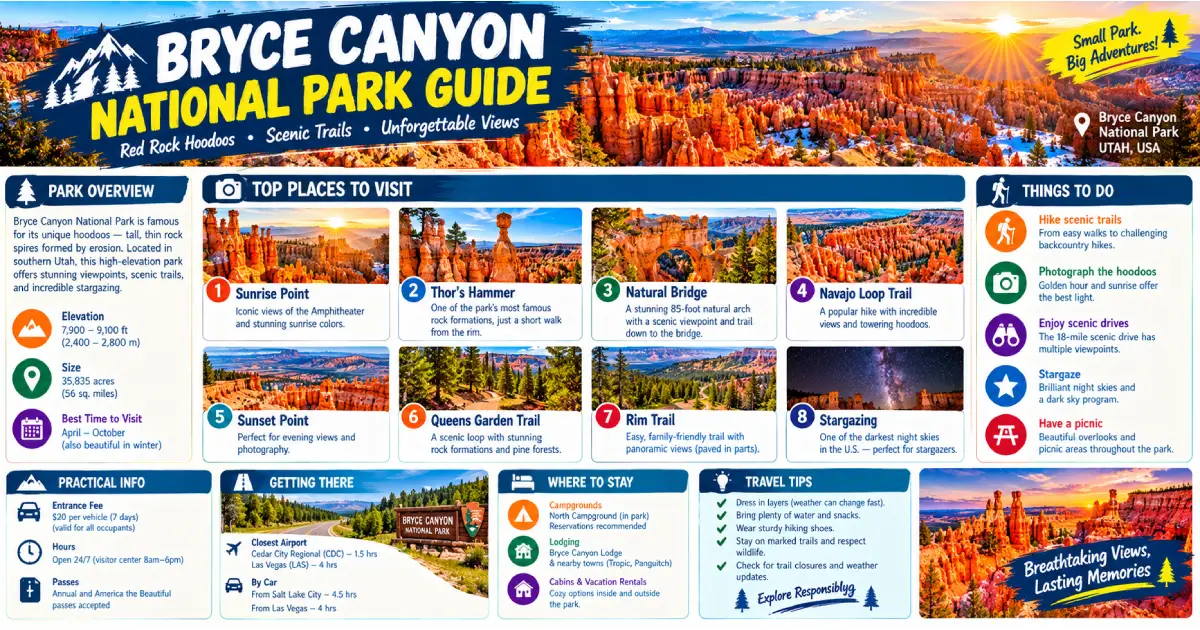
Bryce Canyon is not a canyon at all — it is a series of natural amphitheaters carved into the eastern edge of the Paunsaugunt Plateau in southern Utah, where the combined forces of freezing water, snowmelt, and rain have sculpted the pink and orange Claron limestone into the most extraordinary concentration of hoodoos on Earth. Hoodoos — the tall, thin spires of rock formed when harder capstone protects the softer limestone beneath from erosion — exist in other parts of the world, but nowhere in the numbers, the scale, and the color that they reach here. The main Bryce Amphitheater alone contains an estimated 8,000 hoodoos packed into a 12-square-mile bowl, their colors ranging from cream and pale yellow at the base through layers of salmon, tangerine, and deep rust — the iron oxide and manganese that stain the Claron limestone in every shade between white and burgundy.
At 8,000 to 9,100 feet of elevation, Bryce Canyon is one of the highest national parks in the country, and that altitude shapes everything about the experience. The air is thin and cool even in midsummer (highs of 80°F at the rim, 60°F at night), the light has a clarity and intensity that makes the hoodoo colors almost unreal at dawn and dusk, and the night sky — Bryce Canyon is one of the designated International Dark Sky Parks in the world, with some of the darkest skies measurable anywhere in the continental United States — is among the finest stargazing destinations on Earth. The park receives over 2.5 million visitors annually, concentrated almost entirely in the May–October window, and the main amphitheater viewpoints can be genuinely crowded at midday. The solution is simple: arrive at sunrise, hike before 10 AM, and stay until after sunset.
What separates Bryce Canyon from most national parks is that the most spectacular scenery is not at the rim but inside the amphitheater — and hiking down among the hoodoos is accessible to a far broader range of hikers than the strenuous canyon trails at the Grand Canyon or the exposed ridges at Zion. The Navajo Loop descends 520 feet into the amphitheater through a slot canyon called Wall Street, emerges among the densest cluster of hoodoos in the park, and returns to the rim — all in 2.9 miles. Combined with the Queen’s Garden Trail, it forms a 3-mile loop that may be the single finest short hike in the entire Utah national park system. Understanding this — that the park rewards those who go down, not just those who look from the top — is the key to experiencing Bryce Canyon fully.
| Category | Detail |
|---|---|
| Park entrance fee | $35/vehicle (7-day pass) |
| Shuttle required | May–October (free, replaces parking at busy viewpoints) |
| Rim elevation | 8,000–9,105 feet |
| Park size | 35,835 acres |
| Best hike | Navajo Loop + Queen’s Garden (3 miles, 521 ft descent) |
| Longest trail | Under-the-Rim Trail (22.9 miles, backpacking) |
| Best viewpoint | Bryce Point (sunrise) or Inspiration Point (sunset) |
| Stargazing | Among the darkest skies in the continental US |
| Annual Astronomy Festival | June (4 nights, free with park entry) |
| Best season | May–June, September–October |
| Nearest airport | St. George Regional (SGU), 90 miles southwest |
| Park lodging | The Lodge at Bryce Canyon, $175–295/night |
The hoodoos of Bryce Canyon form through a process called frost wedging — repeated freeze-thaw cycles that physically crack the Claron limestone. Bryce Canyon experiences approximately 200 freeze-thaw cycles per year (temperatures below freezing at night, above freezing during the day), the highest frequency of any location in North America, which is why the hoodoos here grow and erode faster than anywhere else. Water seeps into cracks in the rock, freezes and expands, widens the crack, and eventually breaks off chunks of limestone. When a harder, more resistant capstone sits on top of a softer layer, the capstone protects the material directly beneath it while everything around erodes away — creating the characteristic mushroom-topped spire.
The Claron Formation limestone was deposited 50–60 million years ago as sediment in a series of shallow freshwater lakes that covered what is now the Colorado Plateau. The iron oxide (goethite and hematite) deposited with the sediment is responsible for the orange and red colors; manganese creates purple and lavender tones; the white and cream layers are relatively pure limestone with minimal mineral staining. The result is a geological paint-box that changes color with every shift of light — pale yellow at noon, blazing orange at sunrise and sunset, rose-pink in overcast light, and electric crimson in the minutes before a storm.
Sunrise Point — immediately north of the Bryce Canyon Lodge and the first viewpoint accessible from the main parking area — is the finest all-purpose viewpoint for first-time visitors: broad, easily accessible, and positioned to show the full depth and scale of the northern section of Bryce Amphitheater, including the Queen’s Garden below and the distinctive Thor’s Hammer hoodoo visible across the amphitheater. The Rim Trail connects Sunrise Point to Sunset Point (0.5 miles south) and to Bryce Point (2.2 miles south), running along the canyon edge with continuous views. Sunrise here is not actually the best for early light — despite the name, the aspect faces northeast and the hoodoos below are partially in shadow at dawn; Bryce Point is the superior sunrise viewpoint.
Sunset Point (0.5 miles south of Sunrise Point, served by the free shuttle) is the top of the Navajo Loop Trail and the viewpoint directly above Wall Street — the dramatic slot canyon section of the Navajo Loop where the trail descends between two walls of Claron limestone only 4 feet apart, with Douglas firs growing 100 feet tall from the canyon floor reaching for a sliver of sky above. The view from Sunset Point into the amphitheater is arguably the most photographed single frame in the park. Sunset light here is excellent in the late afternoon when the low western sun throws long shadows across the hoodoo field.
Inspiration Point (1.0 mile south of Sunset Point, accessible by shuttle or a short walk from the road) offers the widest single view of Bryce Amphitheater from any fixed point on the rim — the full sweep of the Silent City, the Queen’s Garden hoodoo field, and the Silent City’s eerie congregation of human-scale spires packed so densely they resemble the ruins of an ancient civilization. The upper level of Inspiration Point (a short rocky scramble above the main viewpoint) provides the most complete panorama. Inspiration Point is superb at both sunrise and sunset and is the finest spot for photographing the full amphitheater in a single frame.
Bryce Point (2.5 miles south of the Village, the southernmost viewpoint on the main shuttle route) is the finest single viewpoint in the park for sunrise: positioned at the southern end of the main amphitheater, it faces east-northeast and captures the first light striking the Silent City and the full Bryce Amphitheater from end to end. Arrive 20–30 minutes before sunrise and walk to the point’s farthest overlook for an unobstructed 270-degree view. Bryce Point is also the trailhead for the Peekaboo Loop Trail and the start of the Under-the-Rim Trail — the premier backcountry route in the park.
The 18-mile road south from Bryce Canyon Village to Rainbow Point (the park’s highest point at 9,105 feet) passes a series of viewpoints and geological features that most visitors in a hurry skip. Farview Point (9,100 feet) offers a vast panorama across the Grand Staircase — the layered geological sequence of pink cliffs, grey cliffs, white cliffs, vermillion cliffs, and chocolate cliffs that step down 6,000 feet from the Paunsaugunt Plateau to the Arizona border. Natural Bridge (actually an arch, not a bridge — geologically distinct features) is a 95-foot span of Claron limestone created by erosion of the wall below, one of the most photogenic formations in the park viewable directly from the road. Rainbow Point and Yovimpa Point at the park’s southern terminus offer the longest views available from any South Utah plateau rim — on clear days, more than 100 miles across the Grand Staircase-Escalante landscape.
The Navajo Loop is the most iconic and most rewarding short hike in Bryce Canyon — descending from Sunset Point into the heart of the amphitheater through Wall Street, traversing the densest hoodoo field in the park at the Two Bridges section, and returning via the other leg of the loop. The Wall Street section (counterclockwise from Sunset Point, recommended direction) descends through the slot canyon between limestone walls studded with ancient Douglas firs growing improbably from narrow ledges, then emerges into the silent-city hoodoo field where the spires rise 150–200 feet overhead. The Two Bridges area at the bottom of the loop — two natural stone arches spanning a narrow drainage — is the finest single scene in the park at close range.
Practical notes: Descend via the Wall Street section (clockwise from the trailhead sign, left fork at the first junction), which avoids the most difficult switchbacks on the descent. One section of Wall Street is closed each spring due to rockfall and reopens when cleared (check nps.gov/brca for current status). The entire trail takes 1.5–2.5 hours. Bring water; there is none below the rim. Start early — the switchbacks leading back up to the rim face south and become hot by 10 AM.
The Queen’s Garden Trail descends from Sunrise Point to the largest hoodoo in the park — Queen Victoria, a 25-foot spire whose crown-shaped cap inspired the name — through a garden of smaller formations on the Bryce Amphitheater floor. At 3 miles round trip with only 320 feet of descent (the gentlest in-canyon trail in the park), it is the most accessible below-the-rim experience and the finest option for families with children or visitors with limited hiking experience. The trail takes 1.5–2 hours at a casual pace.
The combination loop — descending the Navajo Loop from Sunset Point, traversing the canyon floor east to Queen’s Garden, and ascending via Queen’s Garden to Sunrise Point — is universally regarded as the finest short hike in Bryce Canyon and one of the best hikes in the Utah national park system. The route combines Wall Street’s drama, the Two Bridges hoodoo gallery, the Queen’s Garden formations, and a continuous traverse of the amphitheater floor that puts the hoodoos at eye level for the full middle section. The shuttle connects Sunrise Point back to Sunset Point (0.5 miles). Allow 2–3 hours; start from Sunset Point (Navajo Loop descent) for the most dramatic opening.
The Peekaboo Loop is the finest full-day hike in Bryce Canyon — a 5.5-mile loop from Bryce Point that descends into the southern section of the amphitheater, traverses terrain that most visitors never reach, and offers the most varied and sustained hoodoo scenery in the park. The trail passes through the Wall of Windows (a cliff face perforated by a series of eroded arches and alcoves), the Cathedral section (the densest concentration of tall, narrow hoodoos below the rim), and the Fairy Castle formations before climbing back to Bryce Point. The trail is shared with mule rides ($110–130/person, 2-hour and 4-hour options from the corral near Bryce Canyon Lodge — reservations at recreation.gov); yield to mules and move to the uphill side of the trail.
Allow 4–5 hours. Bring 2+ liters of water and food. The descent and ascent are both significant — 1,500 feet of total elevation change over relatively short distances means sustained steep terrain. Best done April–June or September–October; summer heat below the rim (80–90°F) makes this genuinely demanding.
The Fairyland Loop is the least-visited major trail in Bryce Canyon — starting at Fairyland Point (1 mile north of the park entrance, no shuttle service, much lighter crowds) and descending into the Fairyland section of the park, which many experienced canyon visitors consider more beautiful and more varied than the main Bryce Amphitheater. The loop passes Tower Bridge (a natural arch connecting two hoodoo towers, 3 miles in — one of the finest formations in the park), traverses the Fairyland Canyon floor, and ascends back to the rim via the Rim Trail. Allow 5–6 hours; start from Fairyland Point for the most dramatic initial descent.
Because Fairyland Loop receives a fraction of the traffic of the main amphitheater trails, it offers the closest experience to solitude available in the park — even in peak season, you may hike for an hour without seeing another party below the rim.
Mossy Cave — 4 miles east of the park entrance on UT-12 — is the most accessible and least-known good hike in the Bryce Canyon area: a flat, short trail along a creek (Water Canyon) to a shallow cave where seeping water has coated the walls with green moss, with a small waterfall visible 0.2 miles from the trailhead. The cave and waterfall are particularly fine after rain or snowmelt. Because this trail begins outside the park boundary, it requires no entry fee. It is the best option for visitors who want a short nature walk without paying the park entrance fee, and excellent for children.
The Under-the-Rim Trail is the premier multi-day backpacking route in Bryce Canyon — a 22.9-mile route from Bryce Point south to Rainbow Point, traversing below the Pink Cliffs through remote sections of the park that see a fraction of the day-hiker traffic. The trail passes eight backcountry campsites with designated tent pads (permit required, $5/person/night + $5 permit fee, recreation.gov, available 4 months in advance). Day hikers can access the trail from six trailheads along the main park road and do out-and-back sections; the Agua Canyon Connector (2.5 miles from the Agua Canyon parking area to the Under-the-Rim Trail and back) is the finest short access into the southern, quieter section of the park.
Bryce Canyon is one of the finest stargazing destinations in the world — a Gold Tier International Dark Sky Park (the highest designation) with limiting magnitudes of 7.4 (the naked eye can detect stars 7.4 magnitudes, compared to 5.0–6.0 in the best suburban skies). On a clear moonless night, the Milky Way core is bright enough to cast shadows, the Andromeda Galaxy is visible to the naked eye as a faint smudge 2.5 million light-years away, and the sky above the hoodoos is dense with stars in a way that is simply not visible from most of the inhabited world.
The Annual Bryce Canyon Astronomy Festival (held in June, 4 nights, free with park admission) brings professional astronomers, NASA representatives, and 80+ telescopes to the park’s natural amphitheater for the finest organized public stargazing event in the national park system. Astronomers set up at Bryce Canyon Airport’s runway (just outside the park, flat and dark) and at the Astronomy Meadow near the Lodge; visitors rotate through telescopes viewing deep-sky objects, planets, and star clusters with guided explanations.
For independent stargazing, the Bryce Point parking area after dark (arrive 30 minutes after sunset, allow eyes 20 minutes to dark-adapt) and the Fairyland Point (even less light pollution than the main area) are the finest locations. Moonrise and moonset times matter enormously — full moon floods the amphitheater with light that eliminates deep-sky viewing but creates surreal silver-lit hoodoo photography. Check moon phases before your visit; new moon periods in May, June, September, and October offer the finest combination of dark skies and comfortable temperatures.
Bryce Canyon in winter is one of the most spectacular and least-visited experiences in the Utah national park system. Snow transforms the amphitheater into a landscape of red and orange hoodoos capped with white, a color combination that is genuinely otherworldly — and because the park receives 94 inches of snow annually (among the highest in Utah), late November through March reliably delivers this experience. The shuttle does not run in winter, and the main park road is plowed but some side roads may be closed; check conditions at nps.gov/brca.
Winter hiking: The Navajo Loop and Queen’s Garden trails are hikeable in winter with microspikes (essential — the packed snow on the switchbacks becomes ice and is extremely dangerous without traction devices; rentals available at the Bryce Canyon General Store). The Rim Trail is typically packed and walkable. The cross-country skiing on the park road and Rim Trail from mid-December through March is some of the finest in southern Utah; the Bryce Canyon Nordic Center (adjacent to the park entrance) offers ski and snowshoe rentals ($15–25/day) and groomed trails.
Winter crowds: Visitation drops 80–90% from peak summer levels; the Lodge at Bryce Canyon is closed December–March (opens mid-March), but the Bryce Canyon General Store and the Bryce Canyon Visitor Center remain open year-round. The experience of descending the Navajo Loop in winter — the canyon nearly silent, snow dusting the Douglas firs and capping every hoodoo spire — is one of the finest nature experiences available in the American West.
Getting there:
Shuttle system (May–October): Free shuttles run from the Shuttle Staging Area in Bryce Canyon City (just outside the park entrance, free large parking lot) to all major viewpoints and trailheads. Private vehicles may still enter the park but parking at main viewpoints fills by 9 AM in summer; the shuttle is almost always faster and less stressful. Shuttles run every 10–15 minutes from 8 AM to 8 PM.
Where to stay:
| Accommodation | Price | Notes |
|---|---|---|
| The Lodge at Bryce Canyon | $175–295/night | Only in-park lodging; motel rooms and historic cabins; book 13 months in advance at recreation.gov |
| North Campground | $20–30/night | 98 sites, open year-round, reservations April–October |
| Sunset Campground | $20–30/night | 100 sites, open April–October, reservations |
| Bryce Canyon City hotels | $100–250/night | Ruby’s Inn (finest value near park), Best Western, Bryce View Lodge |
Where to eat:
Fees and permits:
Best time to visit:
Bryce Canyon sits at the heart of southern Utah’s Grand Circle of national parks, and combining it with neighboring parks on a road trip is both logical and deeply rewarding:
The classic Utah Mighty Five road trip (Zion → Bryce Canyon → Capitol Reef → Canyonlands → Arches) covers approximately 500 miles and is best done in 10–14 days.
Posted By : Vinay
Latest Article
2nd Floor, 39, Above Kirti Club, DLF Industrial Area, Kirti Nagar, New Delhi, Delhi 110015



Travel Tourister is a leading Travel portal where we introduce travellers to trusted travel agents to make their journey hasselfree, memorable And happy. Travel Tourister is a platform where travellers get Tour packages ,Hotel packages deals through trusted travel companies And hoteliers who are working with us across the world. We always try to find new and more travel agents and hoteliers from every nook and corners across the world so that you could compare the deals with different travel agents and hoteliers and book your tour or hotel with the one you have chosen according to your taste and budget.
Copyright © Travel Tourister, India. All Rights Reserved

 Call
 Enquiry