Published on : 20 Jun 2026
By Travel Tourister | Updated June 2026
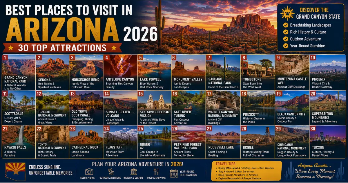
Arizona is America’s most geologically dramatic state — a landscape that compresses 2 billion years of Earth’s history into a single viewable cross-section at the Grand Canyon, produces red-rock formations in Sedona so vivid they appear artificially colored, fills the Sonoran Desert with the world’s only forest of saguaro cacti standing 40 feet tall, and preserves ancient Native American civilizations in cliff dwellings at Canyon de Chelly and Montezuma Castle that have stood for over 800 years. The best places to visit in Arizona span the most iconic natural landmark in America (the Grand Canyon, receiving 6 million annual visitors and still managing to exceed every visual expectation) through a state park system that protects landscapes nearly as extraordinary but far less crowded — Antelope Canyon’s slot canyons, Monument Valley’s sandstone buttes that have defined the visual language of the American West in cinema for a century, and Saguaro National Park’s giant cactus forests — to cities that offer world-class dining, arts, and architecture in Phoenix and Scottsdale alongside one of America’s most distinctive small-city cultural scenes in Tucson.
What makes Arizona genuinely different from other American states as a travel destination is the scale of its natural attractions and their accessibility — the Grand Canyon’s South Rim is reachable from Phoenix in approximately four hours, Sedona’s red rocks in under two, and the surreal landscape of the Painted Desert and Petrified Forest in roughly three, meaning a single week based in Phoenix can plausibly cover an extraordinary range of natural wonders without the logistics of multi-state travel or backcountry camping. The state’s year-round visitation (Phoenix and the desert lowlands best visited October through April; the Grand Canyon’s South Rim accessible year-round with different seasonal characteristics; the White Mountains of northern Arizona providing summer escape from desert heat) means there’s always a portion of Arizona in genuinely ideal visiting conditions regardless of travel dates.
This guide covers the 30 best places to visit in Arizona with practical details — entry costs, driving times from major base cities (Phoenix and Flagstaff), best visiting times, and insider tips — organized to help first-time and return visitors experience Arizona’s extraordinary geographic and cultural range in 2026.
For complete guides, see our Things to Do in Sedona 2026, Grand Canyon Travel Guide, and Best Time to Visit Arizona guides.
| Place | Region | Entry Cost | Best For | Distance from Phoenix |
|---|---|---|---|---|
| Grand Canyon South Rim | Northern AZ | $35/vehicle | Iconic views, hiking | 230 miles / ~4 hrs |
| Sedona Red Rocks | Central AZ | Free (Red Rock Pass for parking $5–$15) | Red rock scenery, hiking, vortexes | 120 miles / ~2 hrs |
| Monument Valley | Northeast AZ | $20/person (Navajo Nation Park) | Iconic buttes, Navajo culture, photography | 300 miles / ~5 hrs |
| Antelope Canyon | Northeast AZ | $70–$100+ (guided tour required) | Slot canyon photography | 275 miles / ~4.5 hrs |
| Saguaro National Park | Tucson | $25/vehicle | Giant cactus forests | 115 miles / ~1.75 hrs |
| Havasu Falls | Northwest AZ | $200–$400+ (permit, lodging) | Turquoise waterfalls, remote beauty | 215 miles / ~3.5 hrs + 10-mile hike |
| Horseshoe Bend | Northeast AZ | $10/person | Colorado River photography | 275 miles / ~4.5 hrs |
| Petrified Forest National Park | Northeast AZ | $25/vehicle | Fossilized wood, Painted Desert | 190 miles / ~3 hrs |
| Canyon de Chelly | Northeast AZ | Free (guided tour required for canyon floor) | Ancient cliff dwellings, Navajo history | 335 miles / ~5.5 hrs |
| Scottsdale | Metro Phoenix | Free | Luxury resorts, arts, dining | 15 miles / 20 min |
| Tucson | Southern AZ | Free | Culture, food, desert nature | 115 miles / 1.75 hrs |
| Oak Creek Canyon | Central AZ | Red Rock Pass | Swimming holes, fall color | 120 miles / ~2 hrs |
| Kartchner Caverns | Southern AZ | $23 (cave tour) | Living caves, geology | 140 miles / ~2 hrs |
| Montezuma Castle | Central AZ | $10 | Ancient cliff dwellings | 100 miles / ~1.5 hrs |
| Tonto Natural Bridge | Central AZ | $7 | World’s largest natural travertine bridge | 105 miles / ~2 hrs |
| Tombstone | Southern AZ | Free (attraction fees vary) | Wild West history | 180 miles / ~2.5 hrs |
| Chiricahua National Monument | Southeast AZ | $25/vehicle | Rock columns, hiking | 200 miles / ~3 hrs |
| Organ Pipe Cactus National Monument | Southern AZ | $25/vehicle | Sonoran Desert, organ pipe cactus | 180 miles / ~2.5 hrs |
| Lost Dutchman State Park | East Metro Phoenix | $7/vehicle | Superstition Mountains, hiking | 40 miles / ~45 min |
| Jerome | Central AZ | Free | Ghost town, arts scene | 110 miles / ~2 hrs |
| Prescott | Central AZ | Free | Victorian architecture, history | 100 miles / ~1.5 hrs |
| Phoenix Art Museum | Phoenix | $25 | Art, culture | Downtown Phoenix |
| Desert Botanical Garden | Phoenix | $29.95 | Desert plants, art installations | 10 miles / 20 min |
| Heard Museum | Phoenix | $22 | Native American art and culture | Downtown Phoenix |
| Taliesin West | Scottsdale | $44–$75 | Frank Lloyd Wright architecture | 15 miles / 20 min |
| Apache Trail (Hwy 88) | East Metro Phoenix | Free | Scenic drive, lakes, desert | 40 miles / ~45 min |
| White Mountains | Northeast AZ | Free (varies by attraction) | Summer escape, forests, fishing | 185 miles / ~3 hrs |
| Painted Desert | Northeast AZ | $25/vehicle (with Petrified Forest) | Colorful badlands | 190 miles / ~3 hrs |
| Wupatki National Monument | Northern AZ | $25/vehicle | Ancient pueblos, volcanic landscape | 200 miles / ~3.5 hrs |
| Flagstaff | Northern AZ | Free | Mountain town, Route 66, gateway city | 150 miles / ~2.5 hrs |
Entry: $35/vehicle (valid 7 days, includes both rims) | From Phoenix: 230 miles, ~4 hours | Best Time: Spring (April–May) and fall (September–October); avoid summer midday
The Grand Canyon is the single most overwhelming natural sight in the United States — a gorge 277 miles long, up to 18 miles wide, and over a mile deep (6,093 feet from South Rim to the Colorado River), exposing rock layers spanning 2 billion years of Earth’s geological history in a visual sequence readable from the rim as a literal textbook of planetary formation. The South Rim (the more accessible and more visited of the canyon’s two developed rims, open year-round) offers a series of viewpoints — Mather Point, Yavapai Point, Desert View — along the rim road that provide the canyon’s most famous perspectives, alongside hiking trails (the Bright Angel Trail and South Kaibab Trail descending into the canyon, from day-hike rim-level walks to the multi-day rim-to-river Colorado River camping expedition).
The sheer scale of the canyon consistently exceeds visitor expectations regardless of how many photographs they’ve seen beforehand — standing at the rim produces a specific perceptual disorientation (the canyon is too large for normal human distance-estimation to function correctly, making depths and distances genuinely difficult to gauge) that no photograph or description fully prepares visitors for. This is the defining characteristic of a Grand Canyon visit: the experience of confronting something that exceeds human visual comprehension in real time.
The South Rim Village (containing lodges, restaurants, visitor centers, and the Grand Canyon Museum Collection) provides full services, while the rim trail (paved, wheelchair accessible, running 13 miles between Mather Point and Hermit’s Rest) allows rim-level exploration without descending into the canyon. Shuttle buses operate free between viewpoints and trailheads during peak season, reducing parking challenges at specific viewpoints.
Insider tips: Sunrise at Mather Point (the first viewpoint accessible from the main visitor parking area) is one of America’s most extraordinary daily natural events — the canyon’s colors shift from pre-dawn blue through pink, orange, and gold as the sun rises, casting successive shadows that transform the visible landscape by the minute. Arrive 30–45 minutes before sunrise for parking and positioning. Never attempt to hike to the Colorado River and back in a single day — the National Park Service explicitly advises against “rim to river” day hikes due to the elevation change, heat, and physical demands, and rescue operations for unprepared hikers attempting this are common during summer months.
Entry: Free to visit; Red Rock Pass required for parking at most trailheads ($5 daily, $15 annual) | From Phoenix: 120 miles, ~2 hours | Best Time: March–May, October–November
Sedona presents one of the American Southwest’s most dramatically beautiful landscapes — a town of approximately 10,000 permanent residents surrounded entirely by red Permian-era sandstone formations (Cathedral Rock, Bell Rock, Courthouse Butte, Oak Creek Canyon’s red walls) that glow in colors ranging from deep crimson at sunrise to almost fluorescent orange at midday to purple at sunset, creating a visual environment so extraordinarily colored that first-time visitors consistently report disbelief at the unfiltered appearance. The red rock landscape drives Sedona’s identity as both an outdoor recreation destination (over 200 miles of hiking, mountain biking, and off-road vehicle trails through the surrounding Coconino National Forest) and a spiritual/wellness destination (the town’s “energy vortex” sites — Cathedral Rock, Bell Rock, Airport Mesa, and Boynton Canyon — have attracted spiritual seekers since the 1980s and now draw visitors specifically seeking the meditative and energetic experiences associated with these locations).
The town itself has evolved into a sophisticated tourism destination (art galleries, spa resorts, upscale restaurants) that operates at a premium price point relative to other Arizona destinations — accommodation and dining costs in Sedona are significantly higher than Phoenix or Flagstaff, reflecting the town’s tourist-economy orientation and limited residential base. The Tlaquepaque Arts & Shopping Village (a beautifully designed Mexican-inspired courtyard shopping complex) and the Sedona Heritage Museum provide town-based cultural experiences alongside the dominant outdoor recreation focus.
Insider tips: The most photographed Sedona view — Cathedral Rock reflected in Oak Creek at Red Rock Crossing — requires a short walk from the Red Rock Crossing/Crescent Moon Recreation Area trailhead (Red Rock Pass required), arriving in the hour before sunset for maximum color saturation. The crossing itself (wading through Oak Creek, typically ankle-to-knee deep, to reach the prime photography position) is worth the wet feet. Sedona’s most significant visitor management challenge is parking at popular trailheads — arriving before 8 AM or after 4 PM reduces competition for the limited trailhead parking areas substantially.
Entry: $20/person (Navajo Nation Tribal Park, not National Park Service) | From Phoenix: 300 miles, ~5 hours | Best Time: Sunrise and sunset; spring and fall for comfortable temperatures | Note: Located within Navajo Nation; Navajo Nation regulations apply
Monument Valley — the collection of sandstone buttes (The Mittens, Merrick Butte, the Three Sisters, and others) rising from the desert floor of the Colorado Plateau on the Arizona-Utah border — is quite possibly the single most photographed landscape in the American West, having appeared in decades of Hollywood westerns (John Ford filmed here repeatedly, and the specific butte formations visible from US-163 have become shorthand for “the American Southwest” in global visual culture). The Navajo Nation Tribal Park preserves the landscape and the Navajo community’s ongoing relationship with it — the valley floor (accessible via a 17-mile self-guided drive on an unpaved road navigable by most 2WD vehicles in dry conditions) brings visitors closer to the buttes than the iconic overlook viewpoint, though guided Navajo-led tours provide access to areas closed to self-guided visitors and historical/cultural context unavailable from self-guided exploration.
The sunrise experience (the most sought-after photographic moment, when the rising sun illuminates the east-facing butte faces while the western faces remain in deep shadow) requires either staying at The View Hotel (the only accommodation within the park, positioned specifically for sunrise monument views, requiring advance booking months ahead) or arriving before dawn from nearby Kayenta or Mexican Hat.
Insider tips: The iconic highway photograph (US-163 approaching Monument Valley from the north, with the road stretching toward the buttes on the horizon) is taken from a pullout north of the park boundary — no fee required for this specific image, which is the most commonly reproduced Monument Valley photograph. For deeper engagement with the landscape and its Navajo cultural context, hiring a Navajo-guided tour (jeep tours, horseback rides, and photography tours available from multiple operators near the park entrance) provides access to canyon areas and historical sites beyond the self-guided drive.
Entry: $70–$100+ per person (guided tour required; Upper Canyon tends to be more expensive than Lower Canyon) | From Phoenix: 275 miles, ~4.5 hours | Location: Page, AZ (Navajo Nation) | Best Time: Midday (10 AM–1 PM) for light beams in Upper Canyon; book weeks-months ahead
Antelope Canyon, a narrow slot canyon carved by flash flooding through Navajo sandstone on the Navajo Nation near Page, Arizona, has become one of the world’s most visited photographic destinations — the sinuous, wave-like walls (eroded into flowing curves by centuries of water flow through the narrow passage) catch and diffuse light into extraordinary illuminated beams during midday hours in the Upper Canyon, creating the signature Antelope Canyon photography that has appeared in countless travel publications and photography exhibitions. The canyon’s walls range from 4 to 25 feet apart at various points, with the slot reaching depths of 120 feet and heights of 150 feet, creating a passage of continuously varying light quality as the sun angle shifts throughout the day.
Two distinct canyon sections exist: Upper Antelope Canyon (Tsé bighánílíní, “the place where water runs through rocks,” more famous, slightly easier walking, famous for the light beam phenomenon) and Lower Antelope Canyon (Hazdistazí, “spiral rock arches,” less crowded, requires ladder climbing, arguably more dramatic structural formations but less famous for light beams). Both require guided tours operated by licensed Navajo-owned tour companies — independent entry is not permitted, and this policy is strictly enforced.
Insider tips: Book tours as far in advance as possible — popular morning time slots at Upper Antelope Canyon sell out weeks or months ahead during peak season (March through October). Photography tours (specifically designed for tripod use and longer exposure times, typically more expensive than standard tours) provide the best conditions for capturing the canyon’s famous imagery, but standard tours also allow photography. The canyon’s famous “light beams” occur only during midday hours on sunny days — overcast conditions eliminate this specific phenomenon entirely, making weather conditions on the tour day genuinely important.
Entry: $10/person | From Phoenix: 275 miles, ~4.5 hours | Location: Page, AZ | Best Time: Sunrise or sunset; avoid summer midday
Horseshoe Bend, where the Colorado River makes a nearly 270-degree horseshoe-shaped meander below a 1,000-foot cliff face approximately 5 miles downstream from the Glen Canyon Dam at Page, Arizona, has become one of the most-photographed locations in the American Southwest — a 1.5-mile round-trip walk from the parking area (paved, accessible but with some slope) delivers visitors to the canyon rim, where the river’s characteristic red-brown water curves dramatically below in a geological feature both immediately comprehensible and visually astonishing. The view requires standing close to the rim edge (guardrails are absent at the primary viewpoint — the canyon is open and unenclosed, which contributes to both the dramatic photography and the occasional serious accident from visitors not exercising appropriate caution).
Horseshoe Bend’s proximity to Page (and therefore to Antelope Canyon, Lake Powell, and the Glen Canyon National Recreation Area) makes it a natural combination with those attractions on a northern Arizona itinerary — the 15-minute drive from the Antelope Canyon tour company area to the Horseshoe Bend parking lot and the minimal time commitment (1.5-mile walk, 30-60 minutes total) make it accessible even within a time-constrained day trip.
Insider tips: The sunrise photography (golden light on the canyon walls and reflected in the river) and sunset photography (warm light on the outer canyon faces, dramatic shadow play on the river meander below) are both excellent — sunrise typically involves somewhat fewer crowds than sunset, particularly on summer weekends when the parking area fills early and afternoon heat makes the walk uncomfortable. A wide-angle lens (or the widest available phone camera setting) is essential for capturing the full meander in a single frame — the view is too broad for standard focal lengths to encompass completely.
Entry: Permit-based, $200–$400+ total (permit fees plus mandatory Havasupai Tribe campground/lodge fees) | From Phoenix: 215 miles to Hualapai Hilltop trailhead (~3.5 hrs), then 10-mile hike to campground | Best Time: April–May, September–October | Permits: Released annually, sell out within minutes
Havasu Falls — a 100-foot waterfall cascading into a turquoise-blue pool within the Havasupai Tribal lands deep in a side canyon of the Grand Canyon — is arguably the most visually extraordinary single natural feature in Arizona, combining the desert’s red-rock canyon environment with intensely turquoise water (the color produced by high calcium carbonate concentrations that remain dissolved at the specific water chemistry of Havasu Creek) in a combination that strikes most visitors as almost impossibly beautiful for a natural landscape. The falls are accessible only on foot (10 miles from the Hualapai Hilltop trailhead to the campground, with the falls appearing approximately 2 miles before the campground) or by helicopter (limited service, weather-dependent, expensive), requiring physical commitment that keeps the location genuinely remote despite its fame.
Permits (required for both camping and the limited lodge accommodation within the canyon) are released on specific dates — typically in February for the following season — and sell out within minutes through the Havasupai Tribe’s online permit system, creating a lottery-like competition that requires advance preparation, a reliable internet connection, and ideally multiple people attempting the booking simultaneously during the release window.
Insider tips: The permit release dates and specific booking procedures change periodically — checking the official Havasupai Tribe website (havasupaitribe.com) for the most current booking process is essential, as third-party information is frequently outdated. The 10-mile hike (1,000 feet of elevation loss going in, the same elevation gain returning) is manageable for reasonably fit hikers at appropriate temperatures (spring and fall) but genuinely demanding in summer heat — the canyon’s depth makes temperatures significantly higher than the surrounding desert plateau, and summer visits have resulted in heat-related medical emergencies.
Entry: $25/vehicle | From Phoenix: 190 miles, ~3 hours | Best Time: Year-round; spring and fall for most comfortable temperatures
Petrified Forest National Park preserves one of the world’s largest concentrations of petrified wood — ancient tree trunks (primarily Araucarioxylon arizonicum, a conifer that grew 225 million years ago) buried by volcanic ash, replaced over millennia by silica from groundwater, and now exposed by erosion as colorfully mineralized “stone logs” scattered across a badlands landscape. The crystalline structure of the petrified wood (quartz crystals replacing the original wood fiber in precise detail, often including preserved bark texture and growth rings) creates specimens that range from plainly brown to vivid reds, purples, yellows, and blacks depending on mineral content — among the most visually extraordinary geological features accessible to casual visitors in the American Southwest.
The park’s northern section encompasses the Painted Desert — badlands of multicolored Chinle Formation clay and mudstone (purples, reds, grays, and yellows in horizontal bands reflecting different mineral compositions of successive geological layers) most dramatically lit by the low-angle light of early morning or late afternoon, when shadows emphasize the terrain’s texture and color bands achieve maximum saturation. The combination of petrified wood in the southern section and Painted Desert vistas in the northern section makes this one of the most visually diverse single-park experiences in Arizona.
Insider tips: Removing petrified wood from the park is a federal crime — the park’s visitor center maintains a “conscience collection” of illegally removed specimens returned by guilty former visitors, often with letters describing subsequent bad luck the writers attributed to their theft, which has become something of a park legend. The 28-mile park road (one-way through the southern section, requiring visitors to return to Highway 40 to access the northern Painted Desert) can be driven in 2-3 hours with stops, or more leisurely across a full day for those wanting to hike specific trails.
Entry: Free (monument entry); guided tours required for canyon floor access, prices vary by tour operator | From Phoenix: 335 miles, ~5.5 hours | Best Time: Spring and fall | Note: Located within Navajo Nation
Canyon de Chelly (pronounced “Canyon de Shay,” from the Navajo Tséyi’ meaning “rock canyon”) preserves one of the most historically continuous human occupation sites in North America — cliff dwellings built by ancestral Pueblo people (Anasazi) approximately 1,000-2,000 years ago, within canyon walls that have housed human communities across multiple subsequent cultures through the present day, as Navajo families continue farming the canyon floor seasonally under special use permits within the monument boundaries. The visual scale (canyon walls rising to 1,000 feet, with white and red sandstone alternating in dramatic horizontal bands, and prehistoric cliff dwellings visible in alcoves carved naturally into the canyon walls) is extraordinary by any measure, and the cultural continuity (the canyon is genuinely a living cultural landscape rather than a purely archaeological site) adds human dimension that pure geology alone doesn’t provide.
Rim drives (North Rim Drive and South Rim Drive, both free, accessible by private vehicle) provide overlook viewpoints of the canyon without guided tours — the White House Overlook (South Rim, 6 miles from the visitor center) offers the most dramatic single viewpoint, with the White House Ruin (a multi-story cliff dwelling) visible approximately 600 feet below the rim. The White House Trail (2.5 miles round trip, one of the very few trails visitors can walk without a guide) descends to the canyon floor for a closer look at the White House Ruin specifically.
Insider tips: The most comprehensive Canyon de Chelly experience involves hiring a Navajo guide for a canyon floor jeep tour — the canyon’s interior landscape (sand dunes, cottonwood groves along the stream, Spider Rock, and additional cliff dwellings beyond the White House) is only accessible by guided tour (with the single exception of the White House Trail) and is substantially more impressive at floor level than from the rim overlooks. Guides are available through the monument’s visitor center and from individual Navajo-owned operators.
Entry: $25/vehicle | From Phoenix: 115 miles, ~1.75 hours | Location: Two districts flanking Tucson (East and West) | Best Time: October–April; sunrise and sunset for photography
Saguaro National Park protects the world’s only forest of saguaro cacti (Carnegiea gigantea) — the quintessential large columnar cactus of the Sonoran Desert, reaching heights of up to 40 feet and weights exceeding 3,000 pounds (with most of that weight being stored water), living up to 150-200 years, and not beginning to grow their first arm until approximately 75 years of age. The Sonoran Desert setting in which they grow is itself one of North America’s most biodiverse desert ecosystems — over 2,000 plant species, 60 mammal species, and significant bird diversity (saguaros provide nesting cavities for numerous bird species including Gila woodpeckers and elf owls) create a landscape that’s dynamically alive rather than the barren wasteland that “desert” might suggest.
The park’s two districts (Rincon Mountain District east of Tucson, and Tucson Mountain District west) each offer a loop drive (Cactus Forest Drive in the east, Bajada Loop in the west) alongside multiple hiking trails — the Rincon Mountain District’s higher elevation (including wilderness backcountry with camping) provides more varied terrain and ecology than the western district, while the western Tucson Mountain District’s more accessible flat terrain and denser saguaro concentration make it the more popular visitor destination.
Insider tips: Saguaro flowers (the Arizona state flower, a white bloom appearing at the very top of mature saguaro arms) appear in May–June, making late spring a particularly distinctive visiting window — the flowers appear for only 24 hours each before closing and falling, making the bloom period somewhat fleeting but visually extraordinary when it occurs. Visiting both park districts (east and west of Tucson) in a single day is feasible — the drives aren’t long individually, and the two districts have genuinely different landscape character worth comparing.
Entry: Free to explore | From Phoenix: 15 miles, ~20 minutes | Best Time: October–April (resort season)
Scottsdale operates as the Phoenix metropolitan area’s luxury tourism district — world-class resort hotels (The Phoenician, Four Seasons Resort Scottsdale, Boulders Resort among dozens), a nationally recognized dining scene, Old Town Scottsdale’s gallery district (one of the country’s most active commercial art markets for Western and Native American art alongside contemporary galleries), and spa culture that has made “Scottsdale spa weekend” a recognizable American travel category. The city’s position against the McDowell Mountains and adjacent to the Sonoran Desert provides both dramatic scenery and direct access to outdoor recreation (hiking in the McDowell Sonoran Preserve, the largest urban wilderness preserve in the United States, offering 225+ miles of trails within city limits).
Old Town Scottsdale (walkable downtown district centered around Scottsdale Road and Main Street) provides the most concentrated visitor experience — galleries, restaurants, the Scottsdale Museum of Contemporary Art, and the Scottsdale Historical Museum anchor a pedestrian-friendly arts and entertainment district that hosts the Barrett-Jackson Collector Car Auction (one of the world’s most significant car auction events, held annually in January) and various arts festivals. The Scottsdale Waterfront development (along the Arizona Canal) adds restaurants and retail to the city’s walkable downtown core.
Insider tips: Taliesin West (see #25) is located in Scottsdale’s northeastern reaches — combining an Old Town exploration with a Taliesin West afternoon tour creates an efficient full-day Scottsdale itinerary covering both the arts/cultural and architectural highlights. The McDowell Sonoran Preserve’s Gateway Trailhead (Tom’s Thumb and Gateway Loop Trails among others) provides direct urban-wilderness access that Scottsdale’s resort-heavy reputation doesn’t always telegraph — genuinely excellent desert hiking within city limits.
Entry: Free to explore | From Phoenix: 115 miles, ~1.75 hours | Best Time: October–April
Tucson offers a version of Arizona that Phoenix’s rapid growth and development have significantly altered — a university city (University of Arizona, founded 1885) with genuine cultural depth (the Tucson Museum of Art, the Arizona State Museum on the UA campus with one of the country’s most significant Native American collections, and a local arts scene of meaningful substance), an exceptionally diverse and influential restaurant scene (Tucson was the first American city designated a UNESCO City of Gastronomy in 2015, reflecting its unique Sonoran border food culture that blends Mexican, Native American, and Anglo culinary traditions), and a preserved historic character in the Barrio Viejo and Fourth Avenue neighborhoods that Phoenix’s suburban development model hasn’t replicated.
The food culture specifically warrants mention — Tucson’s Sonoran-style Mexican food (characterized by the flour tortilla tradition of the borderlands, distinctive regional dishes like the Sonoran hot dog, and restaurants that have operated for decades serving recipes from specific regional Mexican traditions) is among the most distinctive in America, and the Fourth Avenue and downtown restaurant scenes have attracted national recognition independent of the city’s natural-setting appeal.
Insider tips: Combining Tucson with Saguaro National Park and Kartchner Caverns (see #13) creates a natural southern Arizona day-trip or overnight itinerary from Phoenix — the geographic clustering allows efficient coverage of genuinely diverse experiences (urban food culture, natural cactus forest, underground cave geology) within a manageable driving range.
Entry: Red Rock Pass for parking at swimming holes ($5 daily) | From Phoenix: 120 miles, ~2 hours | Best Time: April–June (spring flowers and comfortable swimming), September–October (fall color)
Oak Creek Canyon, the dramatic gorge through which Oak Creek flows from above Flagstaff southward to Sedona, offers Arizona’s most celebrated scenic drive (Highway 89A between Flagstaff and Sedona, continuously following the creek through red-walled canyon scenery) alongside some of the state’s most popular natural swimming areas — Slide Rock State Park (a natural water slide in the slickrock, one of Arizona’s most visited swimming destinations) and various creek access points where red rock canyon walls meet clear cold water in combinations that feel more like national park backcountry than accessible roadside scenery.
The fall foliage (October–November, when the canyon’s riparian cottonwoods, sycamores, and Arizona maples turn gold, orange, and red against the permanent red rock backdrop) creates one of Arizona’s most remarkable autumn color experiences — unusual in a state not typically associated with fall foliage, but the canyon’s specific tree species and protected microclimate produce genuine color displays.
Insider tips: Slide Rock State Park specifically draws enormous summer crowds (parking lots full before 9 AM on summer weekends, with entry cutoffs when capacity is reached) — visiting on weekday mornings or during the shoulder seasons significantly improves the experience. The canyon drive itself (Highway 89A) is equally worthwhile regardless of swimming or Slide Rock access — the road’s constant proximity to Oak Creek and the canyon walls makes it one of America’s most scenic 14-mile highway segments.
Entry: $23/person (cave tour, advance reservation strongly recommended) | From Phoenix: 140 miles, ~2 hours | Best Time: Year-round (constant 68°F / 20°C inside) | Book: Weeks ahead
Kartchner Caverns, discovered in 1974 by two Tucson-area cavers who kept their discovery secret for 14 years to protect the cave from damage before ensuring proper preservation infrastructure was in place, represents Arizona’s most remarkable geological secret — a “living” limestone cave (meaning active water flow continues depositing minerals and growing formations, unlike “dead” caves where water has ceased) containing formations of extraordinary variety and size, including the world’s longest soda straw stalactite (a fragile hollow calcite formation 21 feet 3 inches long) and a 58-foot column (the Kubla Khan formation, visible in the Rotunda/Throne Room Tour).
The cave maintains a constant temperature of 68°F and 99% humidity — the interior atmosphere that preserves active formation growth, and that makes the cave comfortable year-round regardless of outside conditions (genuinely valuable in Arizona’s summer heat). Two tours are available: the Rotunda/Throne Room Tour (year-round, the signature tour covering the cave’s most spectacular formations) and the Big Room Tour (seasonal, closed during bat maternity season from April through October when the Big Room serves as a bat nursery for the cave’s 2,000 cave myotis bats).
Insider tips: Advance reservations are genuinely essential — Kartchner Caverns limits daily visitor numbers to protect the living cave’s humidity and formation growth, and popular dates fill weeks or months ahead. The cave’s constant conditions make it one of Arizona’s best hot-weather escape options — entering a humid 68°F environment when outside temperatures are 105°F provides one of the more startling climate contrasts available in the state.
Entry: $10/person | From Phoenix: 100 miles, ~1.5 hours | Best Time: Year-round; avoid summer midday heat | Note: Climbing into the castle not permitted
Montezuma Castle, a 20-room cliff dwelling built by the Sinagua people approximately 800-1,000 years ago in a natural limestone alcove approximately 90 feet above the valley floor of Beaver Creek (named erroneously “Montezuma’s Castle” by 19th-century settlers who incorrectly believed it was Aztec in origin rather than ancestral Puebloan — an error that has stuck despite historical correction), represents one of the best-preserved prehistoric cliff dwellings in North America. The structure’s remarkable preservation (the adobe walls and original roof timbers remaining largely intact across eight centuries) results from the natural limestone overhang’s protection from rain and direct sunlight, combined with the relatively dry Arizona climate.
A 0.33-mile paved trail (wheelchair accessible, flat, short) along Beaver Creek below the cliff dwelling provides viewing of the castle from ground level — the structure’s height and the prohibition on climbing prevent closer access, but the views from the trail adequately convey the architectural achievement of constructing a five-story stone-and-adobe structure in a cliff alcove using only hand tools and materials available within the immediate landscape.
Insider tips: The monument includes Montezuma Well (approximately 11 miles north, separate entrance, also included with the same admission ticket) — a naturally occurring limestone sink that fills with 1.5 million gallons of naturally warm, slightly carbonated water daily, around which another Sinagua community built irrigation systems and structures 1,000 years ago. The Well is less visited than the Castle but equally historically significant and more geologically unusual — both sites together make a complete 2-3 hour visit.
Entry: Free to explore | From Phoenix: 110 miles, ~2 hours | Best Time: Year-round; spring and fall most comfortable
Jerome, a former copper mining town clinging to the nearly vertical face of Cleopatra Hill (with an elevation drop of approximately 1,500 feet across the town’s residential and commercial streets — the most dramatically situated incorporated town in Arizona and arguably the entire American Southwest), experienced a boom-and-bust cycle so extreme that it transitioned from a population of 15,000 at its peak in the early 20th century to fewer than 100 residents in the 1950s before artists and free spirits discovered and repopulated it beginning in the 1960s, creating the specific combination of genuine ghost town atmosphere and active contemporary arts community that makes Jerome one of Arizona’s most visited small towns.
The town’s vertiginous layout (many “streets” are essentially staircases, and vehicles navigate switchbacks that feel genuinely precarious), preserved historic buildings from the mining era (the Jerome Historical Society Mine Museum, the former jail that has slid several feet downhill over the decades due to unstable mine-blast-damaged ground), and panoramic views of the Verde Valley below (Sedona’s red rocks visible in the distance, the San Francisco Peaks above Flagstaff visible on clear days) create an environment unlike any other in Arizona.
Insider tips: Jerome’s streets are genuinely steep and uneven — comfortable walking shoes and appropriate mobility awareness are genuinely important here, not just standard travel advice. The town’s compact size (the walkable historic commercial area covers a small footprint) means a complete Jerome visit takes 2-3 hours, making it a natural add-on for Sedona visitors who continue north toward Flagstaff or Prescott rather than returning to Phoenix the same way.
Entry: Free to explore | From Phoenix: 150 miles, ~2.5 hours | Best Time: June–September (summer escape from Phoenix heat); fall foliage October
Flagstaff provides the most significant counterpoint to Arizona’s desert identity — a mountain city (6,910 feet elevation, making it higher than Denver’s downtown) surrounded by the world’s largest contiguous ponderosa pine forest, situated at the base of the San Francisco Peaks (the highest point in Arizona, Humphreys Peak reaching 12,637 feet), and experiencing four genuine seasons (including regular winter snowfall that makes it a legitimate ski destination at the Arizona Snowbowl ski area on the San Francisco Peaks). The city’s downtown Historic District (preserved Route 66 commercial architecture, walkable restaurant and bar scene, the Lowell Observatory where Pluto was discovered in 1930, and the Museum of Northern Arizona covering the Colorado Plateau’s geology, ecology, and indigenous cultures) creates a genuinely complete urban experience that differentiates Flagstaff from purely pass-through gateway-city status.
Flagstaff’s position as gateway to both the Grand Canyon South Rim (80 miles north) and Sedona (30 miles south) makes it the most strategically positioned single base city in northern Arizona — visiting both from Flagstaff requires less driving than either from Phoenix and provides the mountain city’s cooler temperatures as base-camp relief between desert/canyon day trips.
Insider tips: Flagstaff’s elevation means temperatures run approximately 25-30°F cooler than Phoenix in summer — a Phoenix resident or visitor during summer heat will find Flagstaff genuinely refreshing, and the city has accordingly become one of Phoenix’s most popular summer weekend escapes. Lowell Observatory (1400 West Mars Hill Road) offers nightly star-gazing programs (clear nights only, check schedule) that benefit from Flagstaff’s status as one of America’s oldest International Dark Sky Cities.
Entry: Free to explore | From Phoenix: 100 miles, ~1.5 hours | Best Time: April–October (cooler than Phoenix but without Flagstaff’s winters)
Prescott, Arizona’s territorial capital from 1864 to 1867 and again from 1877 to 1889, preserves one of the Southwest’s most intact Victorian-era commercial districts — Courthouse Plaza and the surrounding “Whiskey Row” (a block of historic saloons on Montezuma Street that earned the name during the mining and cattle era) reflect frontier-era architecture that Phoenix’s rapid growth has largely eliminated from the urban core of the state’s capital. The elevation (5,400 feet) produces noticeably cooler temperatures than Phoenix in summer while avoiding Flagstaff’s winter severity, making Prescott one of Arizona’s most livable and most visited small cities for both retirees and recreation-seeking day-trippers.
The Sharlot Hall Museum (a remarkably comprehensive collection of Arizona territorial history including period buildings moved from their original locations to the museum’s grounds) and the Phippen Museum (focused on Western art) provide cultural anchors alongside the outdoor recreation access that Prescott’s Granite Dells (a dramatic granite boulder landscape northeast of downtown, accessible via Watson Lake Park) provides — one of Arizona’s more unexpected scenic environments, where rounded pink granite boulders cluster along the shoreline of a reservoir in patterns that suggest a landscape from another continent.
Insider tips: The Granite Dells (Watson Lake Park, minimal vehicle entry fee) provides one of Arizona’s most photogenic landscapes in a setting most visitors haven’t specifically sought out — the combination of water reflection and granite formations creates photography opportunities that feel uniquely non-Arizonan in character, worth including in a Prescott visit specifically for the visual contrast with the red rock and saguaro landscapes that dominate the state’s iconic imagery.
Entry: $7/vehicle | From Phoenix: 40 miles, ~45 minutes | Best Time: October–April; sunrise for photography
Lost Dutchman State Park, located at the base of the Superstition Mountains on Phoenix’s eastern edge (accessible from downtown Phoenix in approximately 45 minutes), provides the most easily accessible genuine wilderness hiking experience in the Phoenix metropolitan area — the Flatiron (a distinctive flat-topped summit requiring a challenging 3,800-foot elevation gain over approximately 3 miles each way) visible from the park’s trails and viewpoints, with easier hikes (the Siphon Draw Trail and various connecting routes) accessible to visitors seeking less strenuous experiences. The Superstition Mountains themselves (a rugged volcanic range with a legendary history — the “Lost Dutchman’s Gold Mine,” a perhaps-mythical gold deposit supposedly discovered by 19th-century German immigrant Jacob Waltz, has inspired treasure-hunting expeditions and associated folklore for over a century) create a dramatic mountain backdrop visible from much of the eastern Phoenix metropolitan area.
Insider tips: The park name (“Lost Dutchman,” referring to the German-born Jacob Waltz, nicknamed “the Dutchman” in the Americanized usage of the era that applied “Dutch” to German immigrants) and the surrounding gold mine legend have created a specific tourism niche in the Lost Dutchman area — guided Lost Dutchman gold mine tours and treasure-hunting experiences are available from multiple operators near the park, catering to visitors interested in the historical/legendary dimension alongside or instead of the hiking.
Entry: Free | From Phoenix: 40 miles to start of scenic route, ~45 minutes | Best Time: October–April; avoid summer heat | Note: The unpaved section (Tortilla Flat to Roosevelt Dam) may require high-clearance vehicle
The Apache Trail (Arizona Highway 88, unpaved through its most dramatic middle section between Tortilla Flat and Roosevelt Dam) provides Arizona’s most adventurous scenic drive — a former supply road for the construction of Roosevelt Dam (completed 1911, one of the world’s first major concrete dams and still the largest masonry dam in the United States) that winds through the Superstition Mountains along a series of Roosevelt, Canyon, Apache, and Saguaro Lakes (all reservoirs of the Salt River Project providing water and recreation to the Phoenix metropolitan area), with the unpaved section offering views of near-vertical canyon walls, the lakes’ blue waters contrasting with desert hillsides, and the general sensation of dramatic isolation within 60 miles of America’s fifth-largest city.
Insider tips: The unpaved section requires honest assessment of both vehicle capability (high clearance strongly recommended; standard passenger cars are officially possible but genuinely risky in the more challenging sections) and comfort level with narrow, one-lane dirt roads on cliff edges. Tortilla Flat (a small “town” with a historic saloon and restaurant that serves as the last services point before the unpaved section begins) provides a worthwhile stop for the historical atmosphere and the wall of dollar bills that covers essentially every interior surface of the saloon.
Entry: $29.95 adults | From Phoenix: 10 miles, ~20 minutes | Address: 1201 N Galvin Parkway, Phoenix | Best Time: October–April; Desert Bloom (February–March); Las Noches de las Luminarias (December)
The Desert Botanical Garden, located in Papago Park near the Phoenix Zoo in central Phoenix, houses one of the world’s most significant collections of desert plants — over 50,000 plant specimens across 5 miles of garden trails, with particular strength in the cactus and succulents of the Sonoran Desert and related arid-land ecosystems from around the world. The garden’s rotating art installations (outdoor sculpture exhibitions that integrate large-scale contemporary works into the desert plant landscape) and signature seasonal events (the February–March Desert Wildflower Loop showcases spring bloom; December’s Las Noches de las Luminarias transforms the garden into a luminaria-lit evening experience) create programming beyond the permanent botanical collection.
Insider tips: The wildflower bloom season (February–March, peaking at different times each year depending on winter rainfall) represents the garden’s most extraordinary annual period — the desert floor plantings supplemented by wildflower seed beds create color combinations that directly contradict popular assumptions about desert landscapes being primarily brown and barren.
Entry: $22 adults | From Phoenix: Downtown Phoenix | Best Time: Year-round; avoid summer midday heat for the walk between exhibit buildings
The Heard Museum, founded in 1929 by Dwight and Maie Heard in Phoenix, has developed into the most respected institution for the exhibition and interpretation of Native American art and culture in the United States — a comprehensive collection covering Native American cultures across the Southwest and broader North America, with particular strength in Navajo, Hopi, Apache, and O’odham material culture, alongside contemporary Native American fine art that the museum has been instrumental in promoting to national and international recognition. The “Boarding School Era” exhibit (documenting the federal government’s forced assimilation program that sent Native American children to residential schools, separating them from families, language, and culture from the late 19th century through the mid-20th century) represents the museum’s most historically comprehensive and emotionally significant programming.
Insider tips: The Heard Museum Shop (one of the most curated and authentic sources of Native American art, jewelry, and crafts in Phoenix) provides an alternative to the dubious “Native American” goods sold in tourist shops throughout Arizona, with pieces documented as being made by specific artists and tribes.
Entry: $44–$75 depending on tour type | From Phoenix: 15 miles, ~20 minutes | Address: 12621 Frank Lloyd Wright Boulevard, Scottsdale | Best Time: October–April | Book: Advance reservations recommended
Taliesin West, Frank Lloyd Wright’s winter home and studio (built beginning in 1937 and continuously modified until his death in 1959) in the Sonoran Desert foothills northeast of Scottsdale, represents one of America’s most significant architectural sites — both as the winter campus of Wright’s Taliesin Fellowship (the apprenticeship program that trained generations of architects under Wright’s direct supervision) and as a built demonstration of Wright’s organic architecture principles applied specifically to the desert Southwest context. The complex (constructed largely from desert masonry — local stones set in concrete to blend with the surrounding desert floor) incorporates indoor-outdoor relationships, natural material integration, and response to desert light and climate that have influenced American desert architecture fundamentally.
Multiple tour options (ranging from 1-hour introduction tours to extended expert tours of the full campus and studio spaces) accommodate different levels of architectural interest and available time, with the Frank Lloyd Wright Foundation (which operates Taliesin West as a working architecture school and museum) offering the tours year-round with reduced operations during summer heat months.
Insider tips: The Cabaret Cinema (Wright’s outdoor theater/classroom within the Taliesin West complex) is one of the most beautiful outdoor spaces in Arizona — its combination of masonry walls, overhead framework, and desert views behind the “stage” area creates a spatial experience that conveys Wright’s design principles more viscerally than any description or diagram.
Entry: $25/vehicle | From Phoenix: 200 miles, ~3 hours | Best Time: Spring and fall; summer manageable at this elevation | Location: Southeast Arizona (near Willcox and Dos Cabezas)
Chiricahua National Monument protects one of Arizona’s most extraordinary and least-visited landscapes — an “island sky” mountain range in southeastern Arizona, where volcanic eruptions approximately 27 million years ago deposited massive ash fields that subsequently eroded into thousands of rhyolite columns, balanced rocks, and pinnacles clustered so densely they create the “Wonderland of Rocks” that gives the area its descriptive nickname. The landscape is genuinely unlike any other geological formation in Arizona — neither the red rock of Sedona, the slot canyons of the north, nor the desert flatlands of the Phoenix basin, but a dramatic vertical landscape of pale rhyolite columns that catches light dramatically and creates photography conditions unlike those available elsewhere in the state.
The monument’s relative remoteness (the 200-mile drive from Phoenix involves significant highway time) and low visitor numbers compared to the state’s more famous natural attractions create a solitude that Sedona and the Grand Canyon can never offer — serious hikers and photographers who make the effort routinely describe it as among the most rewarding destinations in Arizona.
Insider tips: The Heart of Rocks Loop Trail (7 miles round trip, the most comprehensive single hiking route through the monument’s most dramatic rock formations) requires a full day’s commitment including the drive, but delivers an experience that regular Arizona visitors consistently describe as one of their most memorable state discoveries.
Entry: $25/vehicle (combined with Sunset Crater Volcano, worth visiting together) | From Phoenix: 200 miles, ~3.5 hours | From Flagstaff: 30 miles, ~30 minutes | Best Time: Year-round
Wupatki National Monument preserves the ruins of several hundred prehistoric pueblos (the largest — Wupatki Pueblo itself — containing approximately 100 rooms and having housed an estimated 100-200 people at its peak population around 1100-1200 CE) in the high desert north of Flagstaff, where the eruption of Sunset Crater Volcano around 1085 CE paradoxically attracted new settlers (the volcanic cinders acting as a moisture-retaining mulch that temporarily improved agricultural conditions in an otherwise marginal environment, drawing populations to an area that subsequently became unsustainable after environmental conditions changed).
The monument’s combination of architectural preservation, desert landscape, and accessible interpretation (the self-guided trail around Wupatki Pueblo with informational signs providing historical and architectural context) creates one of Arizona’s most educational ancient-culture site experiences — comparable to Montezuma Castle in visitor-friendliness while offering a different cultural and environmental context.
Insider tips: The combined Wupatki/Sunset Crater Volcano loop road (a scenic 34-mile unpaved/paved combination connecting both monuments, plus the painted vista of the San Francisco Peaks volcanic field) creates one of the best half-day drives from Flagstaff — visiting both monuments in sequence and returning to Flagstaff via the loop road takes approximately 3-4 hours and covers geological and cultural history in striking visual combination.
Entry: $25/vehicle | From Phoenix: 180 miles, ~2.5 hours | Best Time: October–April; spring bloom (February–April) | Note: International border area; check current travel advisories
Organ Pipe Cactus National Monument, the only place in the United States where the organ pipe cactus (Stenocereus thurberi) grows naturally (the species is common in Mexico’s Sonoran Desert but barely crosses the international border into Arizona), protects one of the continent’s most pristine desert wilderness areas along the US-Mexico border. The organ pipe cactus itself (multi-armed like a saguaro but with arms rising from the base rather than from a central trunk, typically growing 15-20 feet tall in numerous parallel columnar “pipes”) creates a landscape distinctive from Saguaro National Park’s single-trunk profile.
The spring wildflower season (February–April, timing depends on winter rainfall) produces some of the Sonoran Desert’s most spectacular color — the monument’s relatively undisturbed ecosystem supports wildflower densities and species diversity that more developed areas cannot match.
Insider tips: Current border area conditions and visitor advisories should be verified before visiting (the monument’s proximity to the international border means security and access considerations can change) — the National Park Service’s website provides current advisories. The Ajo Mountain Drive (21-mile unpaved loop, 2WD-accessible in dry conditions) and Puerto Blanco Drive provide the monument’s primary scenic driving access to areas otherwise requiring significant hiking.
About Travel Tourister Travel Tourister’s destination specialists have explored Arizona from the Grand Canyon’s South Rim at sunrise and Sedona’s red rock trails to Antelope Canyon’s guided slot canyon tours and Tucson’s UNESCO gastronomy scene — to deliver the most practical and honest guide to the best places to visit in Arizona for every type of 2026 visitor.
Posted By : Vinay
Latest Article
2nd Floor, 39, Above Kirti Club, DLF Industrial Area, Kirti Nagar, New Delhi, Delhi 110015
Travel Tourister is a leading Travel portal where we introduce travellers to trusted travel agents to make their journey hasselfree, memorable And happy. Travel Tourister is a platform where travellers get Tour packages ,Hotel packages deals through trusted travel companies And hoteliers who are working with us across the world. We always try to find new and more travel agents and hoteliers from every nook and corners across the world so that you could compare the deals with different travel agents and hoteliers and book your tour or hotel with the one you have chosen according to your taste and budget.
Copyright © Travel Tourister, India. All Rights Reserved
 Call
Call Enquiry